1968 North American Press Bird's-Eye View Map of San Francisco, California
SanFrancisco-firstsavingsloan-1968$350.00

Title
The Exhibition City San Francisco.
1968 (dated) 15.5 x 22.25 in (39.37 x 56.515 cm)
1968 (dated) 15.5 x 22.25 in (39.37 x 56.515 cm)
Description
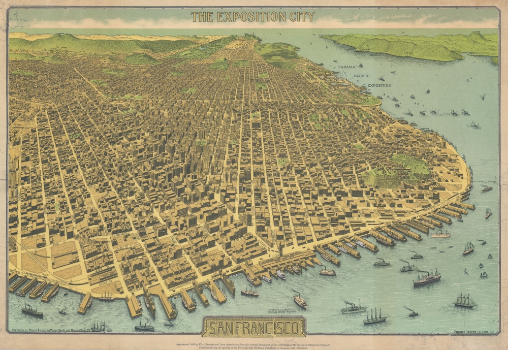
An extraordinary 1968 / 1912 bird's-eye view perspective view and map of San Francisco, risen from the ashes of the 1906 earthquake and fire, ready to retake the world stage by hosting of the Panama-Pacific International Exposition. This view was originally published in 1912, with the present example being a much reduced 198 restrike.
A Closer Look
The view looks westward on San Francisco from a fictional highpoint above today's San Francisco-Oakland Bay Bridge with California Street running dead center. The Embarcadero and docks appear in the foreground, while Golden Gate Park and the Pacific are recognizable in the distance. The Panama-Pacific Exposition, displayed here prospectively, appears at right, near the Golden Gate. Across the bay, in the distance, Mount Tamalpais, with a winding road ascending, is recognizable. The view presents a city fully recovered from a disaster that, just six years prior, destroyed eighty percent of the city. Cartographically the map is noteworthy as it illustrates and names nearly every single building - an astounding achievement and an invaluable record of San Francisco c. 1912.Panama-Pacific International Exposition (PPIE)
The Panama-Pacific International Exposition (PPIE) was a world's fair held in San Francisco between February 20 and December 4, 1915. Ostensibly, the fair was intended to celebrate the completion of the Panama Canal, but it was also an opportunity for San Francisco to showcase its remarkable recovery from the 1906 earthquake. The fair was constructed on a 635-acre site along the northern shore now known as the Marina District. It showcased American industry, progress, and prosperity. The exhibition's pièce de resistance was the 'Tower of Jewels', a 435-foot tower covered in glass Novagems illuminated by powerful searchlights. Little remains of the original fair grounds, except for the Palace of Fine Arts - although the current iteration matches the original, it was completely rebuilt in the 1960s to be more permanent and seismic-resistant.Publication History and Census
This map was published in 1968 to promote the First Savings and Loan Association. This restrike is smaller than the first edition, bears additional promotional text, and the bay is colored a brighter shade of turquoise. It was originally produced on June 22, 1912, and was engraved and printed by the Pingree-Traung Company, of San Francisco, on behalf of the North American Press Association. While Pingree-Traung was a major printing concern, this map and a guide to several California cities seem to constitute the full corpus of the North American Press Association. It was prepared in anticipate of the Panama-Pacific International Exposition (1915). Examples appear on both thin onion-skin paper and on heavier stock (per Rumsey). A second edition was published 2 days after the first on June 24, 1912, and is identifiable by the winding road to the summit of Mount Tamalpais, and names of buildings on the block bounded by First, Bryant, Brannon, and Beale streets. cf. Rumsey 10016.000) to promote the First Savings and Loan Association. The restrike can be identified by its smaller size, additional promotional text appearing below the title block, and evident (but printed) tears in the upper left corner that transferred from the example from which it was created, which is in the collection of the Society of California Pioneers. Of the present 1968 restrike edition, we note an example in the David Rumsey Map Collection. The restrike edition appears on the market from time to time.CartographerS
Pingree-Traung Company (1911 - 1966) was a lithographic printing firm founded in San Francisco in 1911. The company operated at Battery and Green Streets, under this imprint until 1916 when it was renamed 'Traung Label and Lithography'. The firm specialized in fruit box labels and other commercial lithography and chromolithography. In 1926, they purchased the 'Stecher Lithograph Company' of Rochester, New York (founded 1887), and renamed themselves 'Stecher-Traung'. In 1966, the firm was acquired by International Paper and folded into general operations. More by this mapmaker...
North American Press Association (fl. c. 1911 - 1915) was a San Francisco based publishing concern active in the early 20th century. The firm has only 1 recorded copyright entry, a large and dramatic view of San Francisco. However, there is some evidence that they produced fruit-labels, as their advertisements appear in American Fruits as late as 1914. They were based in the Hearst Building. Learn More...
Condition
Very good.
References
Rumsey 10016.000.