
This item below is out of stock, but another example (left) is available. To view the available item, click "Details."
Details
1927 Godwin Pictorial Map of San Francisco, California
$3,000.00
1927 Godwin Pictorial Map of San Francisco, California
SanFrancisco-godwin-1927$1,750.00

Title
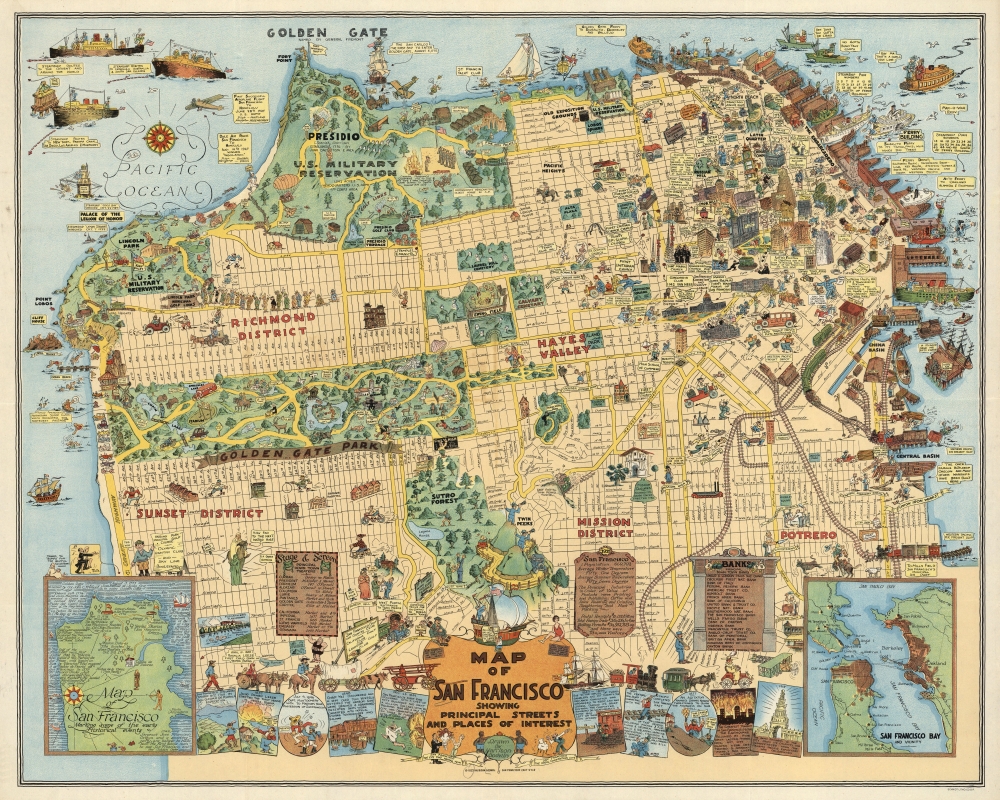
Map of San Francisco Showing Principal Streets and Places of Interest.
1927 (dated) 26.25 x 33 in (66.675 x 83.82 cm) 1 : 13000
1927 (dated) 26.25 x 33 in (66.675 x 83.82 cm) 1 : 13000
Description
This is a 1927 Harrison Godwin pictorial map of San Francisco, California - considered the best genre illustration of that city. Comic illustrations appear alongside depictions of San Francisco landmarks, including the Fine Arts Palace, the Twin Peaks, and Fisherman's Wharf. Golden Gate Park appears in detail, with the many animal enclosures, lakes, and buildings all illustrated. The city's schools, churches, hospitals, post offices, and even the U.S. Mint (complete with workers shoveling gold coins into the back of a van) are marked. A surprising number of golfers and golf courses populate the map, with one fellow holding a sign that reads, 'San Francisco has 365 golfing days in the year'. Placards near the bottom border bear facts about the city and list its banks and theaters. Comic panels line the bottom border and present events in San Francisco's history, from its founding to its many fires. An inset in the lower left marks important events, while the inset in the lower right depicts the Greater Bay Area.
20th Century Pictorial Cartography
Pictorial qualities have been common in cartography from at least the 16th century, when publishers like Braun and Hogenberg incorporated view-like qualities and other pictorial elements into their famous city plans. Braun and Hogenberg, and similar cartographers, issued their town books to express, not necessarily the geography their subjects, but rather the 'essence' of the town/city. As mathematics and surveying principles became more advanced, travel increased, and the ability to translate 2 dimensional cartographic perspectives into an understanding of the actual world became commonplace, maps themselves transformed. This trend is a recognizable progression that evolved cartographic conventions from the 17th to the 19th centuries. By the late 19th century most maps had become geographical tools that illustrated the region cartographically but failed in the original raison d'être as expressed by Braun and Hogenberg, to illustrate a place's 'essence'. So, where a city map of 19th century Paris might provide a completely navigable presentation of the city, one could glean almost nothing of Paris' character from it. In the late 18th century, the first modern 'pictorial' style maps developed. These maps, like Tomas Lopez's 1788 map of Seville attempted to provide both cartographic accuracy and pictorial elements that might convey the character of the city. In that case, Lopez incorporated pictorial vignettes to illustrate important buildings and monuments. This style became increasingly commonly throughout the 19th century and early 20th centuries, particularly for centers of commerce like London, Paris, and Rome, where they are often mass produced and referred to as 'monumental' maps. The style further evolved in the early to mid-20th century, when revolutionary cartographers and illustrators like MacDonald Gill, Jo Mora, Frank Dorn, Ernest Dudley Chase, and many others, combined vignette style illustrations, modern printing techniques, inspiration from Japanese printmaking and manga, and from clever satirical cartographers/artists like Fred Rose, to produce maps that once again focused on revealing the essence a place, usually, but not always, at the sacrifice of cartographic precision.Publication History and Census
This map was created and published by Harrison Godwin in 1927. We note four cataloged examples in OCLC, at Pennsylvania State University, Brigham Young University, the State Library of Oregon, and the California Historical Society. An example is also part of the David Rumsey Map Collection and at the La Jolla Map Museum. It has appeared on the market a half dozen times in the past fourteen years.CartographerS
William Harrison Godwin (March 21, 1899 - January 11, 1984), who went by Harrison, was an American cartoonist, pictorial map artist, and hotelier active in California during the early to middle parts of the 20th century. Harrison was born in Hackettstown, New Jersey. Harrison was a cartoonist with the Los Angeles Examiner and published two daily strips. With regard to cartographic material he published just three maps, San Francisco, Hollywood, and North America, all between the years of 1927 and 1929. The San Francisco and Hollywood maps were the first and second maps in a planned series of American cities, each taking some three months to complete. Curiously, no further maps in the series materialized. In addition to his cartoon work Harrison, in partnership with his brother Fred, owned Carmel-by-the-Sea's La Playa Hotel, where Harrison worked as a manager. Later, in 1940, Harrison sold his interest in the La Playa and acquired full ownership of the Pine Inn, also in Carmel and still active. Harrison and Fred Godwin and are credited with popularizing Carmel as a tourist destination. Little else is known of his life. More by this mapmaker...
Max Heinrich William Schmidt (February 17, 1850 - May 22, 1936) was a German-American engraver, lithographer, and publisher. Born in Schaemhaum, Germany, Schmidt left home at 14 when he chose to go to sea as a cabin boy instead of pursuing a career in medicine, as was family tradition. He spent the next 7 years traveling the world and developed his artistic skills aboard ship, keeping a meticulously lettered logbook. He arrived in San Francisco in 1871 and left his ship. First finding work in a restaurant, Schmidt soon began working for San Francisco lithographers, and spent the next three years working for Korbell Brothers, Grafton, T. Brown (San Francisco's only African American lithographer), and other San Francisco firms and engravers. He set up his own shop in 1874, called Schmidt and Buehler, in partnership with Frederick Buehler. They made pictorial cuts for local newspapers. Schmidt was on his own two years later, working under the name M. Schmidt and Company and producing stock certificates and colored lithographic labels. Schmidt incorporated the firm in 1883 under the name Schmidt Label and Lithographic Company. His factory burned in 1884 and again in 1886. In 1899, Schmidt acquired the lithographic firm Dickman-Jones and H.S. Crocker's label department and formed a new firm called the Mutual Label Company and Lithographic Company. In the early 1900s, Schmidt expanded to Los Angeles, when the Los Angeles Lithographic Company and the Western Lithograph Company became associated with Mutual. In 1906, the Great San Francisco Earthquake and Fire destroyed his company. He soon rebuilt and named the new firm the Schmidt Lithograph Company. Under this imprint, he printed all of Harrison Godwin's (1899 - 1984) famous pictorial maps. Schmidt continued to find success, and eventually expanded to Southern California, Texas, Utah, the Pacific Northwest, Florida, and Honolulu, making labels for producers and packers in all these areas. Although the firm did produce posters, booklets, and other forms of commercial lithography, it mainly focused on labels. The Stecher-Traung Company bought Schmidt Lithograph in 1966 and formed Stecher-Truang-Schmidt, which operated until 1994. Learn More...
Condition
Very good. Mounted on linen.
References
Rumsey 8102.000. OCLC 858943462. Hornsby, S.J., Picturing America: The Golden Age of Pictorial Maps, (Chicago, U. of Chicago Press) 2017. p. 141.