
This item below is out of stock, but another example (left) is available. To view the available item, click "Details."
Details
1854 / c. 1910 Le Breton View of San Francisco, California
1854 (undated) $1,200.00
1950s Gross Map or Plan of San Francisco, California
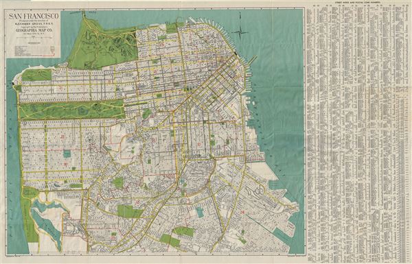
SanFrancisco-gross-1950s$50.00

Title
San Francisco.
1950s (undated) 26 x 41 in (66.04 x 104.14 cm) 1 : 16900
1950s (undated) 26 x 41 in (66.04 x 104.14 cm) 1 : 16900
Description
This is a fine 1950s map or plan of the city of San Francisco, California, issued by Alexander Gross. The map covers the city from the Golden Gate Bridge south as far as city limits and the 'Laguna de la Merced. It notes all major streets, playgrounds, house numbers, piers, parks, transit lines and postal zones, along with a host of other topographical features. A street index with postal zone numbers is included on the right of the map proper. The map comes with the original cover which includes a list of places of interest in San Francisco. This map was produced under the direction of Alexander Gross F.R.G.S., and published by the Geographia Map Company, NY.
Condition
Very good. Minor wear along original fold lines. Blank on verso. Comes with original cover.