This item has been sold, but you can get on the Waitlist to be notified if another example becomes available, or purchase a digital scan.
1938 Thomas Brothers Map or Plan of San Francisco, California
SanFrancisco3-thomasbros-1938$62.50

Title
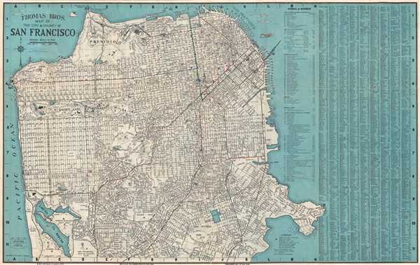
Thomas Bros Map of the City and County of San Francisco.
1938 (undated) 22 x 36 in (55.88 x 91.44 cm) 1 : 17000
1938 (undated) 22 x 36 in (55.88 x 91.44 cm) 1 : 17000
Description
This is a fine c.1938 pocket map or plan of the city of San Francisco by Thomas Bros. It covers San Francisco City from Lake Merced in the south to the Golden Gate Bridge in the north and from Great Highway in the west to Avisadero Point in the east. It notes all major streets, piers, parks, cemeteries, railroads, etc. A street index is included on the right hand side of the map proper. Verso contains a map of Oakland Berkeley-Alameda San Leandro-Piedmont Albany-El Cerrito-Emeryville along with a street index. The whole is surrounded by illustrations of ferry boats, sail boats, ships, seals, mermaids, etc. This map was copyrighted by Geo. C. Thomas and published by Thomas Bros.
Condition
Very good. Minor wear along original fold lines. Professionally flattened and backed with archival tissue.
References
Rumsey 0994.015 (atlas edition).