This item has been sold, but you can get on the Waitlist to be notified if another example becomes available, or purchase a digital scan.
1952 Thomas Brothers Map or Plan of San Francisco, California
SanFrancisco4-thomasbros-1938$77.50

Title
Thomas Bros Map of the City and County of San Francisco.
1938 (undated) 22 x 36 in (55.88 x 91.44 cm) 1 : 17000
1938 (undated) 22 x 36 in (55.88 x 91.44 cm) 1 : 17000
Description
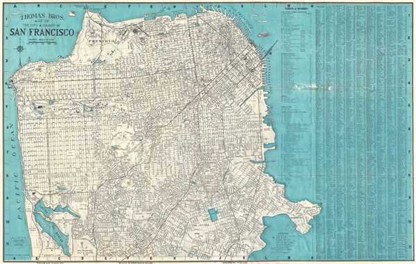
This is a 1952 pocket map or plan of the city of San Francisco by Thomas Bros. It depicts the city of San Francisco from the Golden Gate Bridge to Lake Merced and from the Pacific Ocean to Hunter's Point. Highly detailed, nearly all streets in the city are labeled, along with parks, cemeteries and clubs, including Golden Gate Park, which is illustrated in detail. Ninety-one 'points of interest' around San Francisco are numerically identified and correspond to an index situated in the upper right corner. A street index that lists San Francisco's streets in alphabetical order, provides the grid location of all illustrated streets. Vignettes of fishermen, mermaids, ferries, and birds populate San Francisco Bay and the Pacific Ocean that surround San Francisco.
This map was copyrighted by Geo. C. Thomas and published by Thomas Bros in 1952.
This map was copyrighted by Geo. C. Thomas and published by Thomas Bros in 1952.
Condition
Very good. Wear along original fold lines. Verso repairs to fold separations. Margin tears professionally repaired on verso. Several old repairs on recto. Loss on recto due to one of these old repairs. Map of Oakland, Berkeley, and Alameda on verso.
References
Rumsey 0994.015 (atlas edition).