1906 Ficke View of the San Francisco Earthquake and Fire
SanFranciscoFire-ficke-1906-2$1,200.00


Title
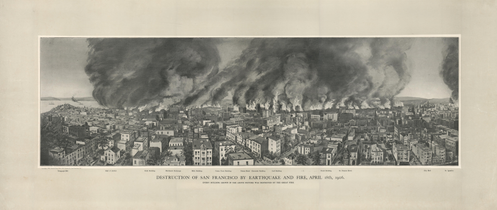
Destruction of San Francisco by Earthquake and Fire, April 18th, 1906. Every Building Shown in the Above Picture Was Destroyed by the Great Fire.
1906 (dated) 12.5 x 35.5 in (31.75 x 90.17 cm)
1906 (dated) 12.5 x 35.5 in (31.75 x 90.17 cm)
Description
A scarce 1906 Francis Ficke view of the destructive earthquake and fire that struck San Francisco on April 18, 1906. It is a first-hand record of the most destructive natural disaster in California's history.
The 'Call Building,' at the time the city's tallest building and the tallest west of the Mississippi River, is prominently on fire at center. Though badly damaged, the building survived the fire and was reopened after renovations. The Palace Hotel, also labeled, was the largest hotel in the Western U.S., but it was not so lucky. The church towards the center-left is likely the 'Old' St. Mary's Cathedral at 660 California Street, which was, along with the Call Building, one of the larger buildings to survive the conflagration.
A Closer Look
This offset lithograph provides a view of San Francisco on that fateful day from Russian and Nob Hills, looking west over the most densely populated and heavily damaged parts of the city, including Chinatown and around Market Street. Ficke displays both earthquake damage, evident in broken windows and several buildings partially or entirely collapsed, and the fires that followed. Several locations are labeled, including Telegraph Hill at left and City Hall (which was completely destroyed) at right.The 'Call Building,' at the time the city's tallest building and the tallest west of the Mississippi River, is prominently on fire at center. Though badly damaged, the building survived the fire and was reopened after renovations. The Palace Hotel, also labeled, was the largest hotel in the Western U.S., but it was not so lucky. The church towards the center-left is likely the 'Old' St. Mary's Cathedral at 660 California Street, which was, along with the Call Building, one of the larger buildings to survive the conflagration.
San Francisco and the 1906 Earthquake
The 1906 San Francisco Earthquake struck on the morning of April 18. Fires soon broke out in the city and raged for several days. In the end, over eighty percent of the city was destroyed by either the earthquake or the fire, and over 3,000 people lost their lives. Estimates state that the subsequent fires caused ninety percent of all the destruction wrought by the disaster. Over thirty fires raged throughout the city over the following four days, destroying nearly 25,000 buildings and 490 city blocks. It remains the deadliest event in California's history and ranks among the worst natural disasters in American history.Publication History and Census
This view was published by Francis Ficke in 1906, with input (likely printing) by 'O.W. Co. Eng's.' There are two known printings, one colored and one uncolored, and examples range from having no border matting at all to maintaining the wide border seen here. Regardless of these variations, the view is scarce, only being noted among the holdings of Stanford University and Crocker Art Museum in Sacramento.Cartographer
Francis Ficke (fl. c. 1895 - 1920) was an artist and lithographer based in San Francisco. Born in New York around 1866, he appears to have relocated to San Francisco in the late 19th century and established a lithographic print shop at 1778 Post Street. Ficke also was involved with socialist causes, notably the group the Co-Operative Brotherhood, an offshoot of Eugene Debs' Social Democracy of America, and their publication, The Co-operator, for which he designed and printed covers and plates. More by this mapmaker...
Condition
Very good. Mounted on heavy linen.
References
OCLC 754863938. Crocker Art Museum 2019.74.46.