1940 Sampson Pictorial Map of the Western United States
SanFranWorldsFair-sampson-1940$125.00

Title
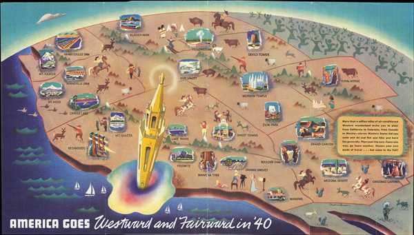
America Goes Westward and Fairward in '40.
1940 (undated) 9 x 16 in (22.86 x 40.64 cm)
1940 (undated) 9 x 16 in (22.86 x 40.64 cm)
Description
This is a 1940 Cornelius Sampson pictorial map of the western United States. The map depicts the United States from the Pacific Coast to Montana, Wyoming, Colorado and New Mexico and from Washington, Idaho, and Montana to the southern border with Mexico. Created for the 1940 Golden Gate International Exposition, the Tower of the Sun, the centerpiece of the exposition, serves as a commanding focal point. Surrounding the Tower of the Sun, vignettes of life in the West and its natural wonders present an inviting adventure for those 'back east.' Cowboys, Native Americans, hunters, fishermen, and miners are all present, harkening back to the romanticized view of the American West. Wildlife dot the landscape, such as bison, bighorn sheep, and deer. Hollywood glamour also makes an appearance, in the form of a director and his leading lady making a movie. Scenes from the most famous western American historical and natural sites are also illustrated, including the Grand Canyon, Yellowstone, Zion National Park, Yosemite, Crater Lake, and Carlsbad Caverns. Mt. Rainier, Mt. Hood, and the Redwoods are also depicted. Along the right border, the crowds of people rushing west to visit all of these wonders are illustrated, stretching to the horizon.
This map was created by Cornelius Sampson and published in a brochure promoting the Golden Gate International Exposition in 1940.
This map was created by Cornelius Sampson and published in a brochure promoting the Golden Gate International Exposition in 1940.
Condition
Very good. Wear along original fold lines. Text and printed photographs on verso. Accompanied by original brochure.
References
Rumsey 8814.000.