This item has been sold, but you can get on the Waitlist to be notified if another example becomes available, or purchase a digital scan.
1763 Vanni Map of St. Augustine, Florida
SantAgostino-vanni-1763$475.00

Title
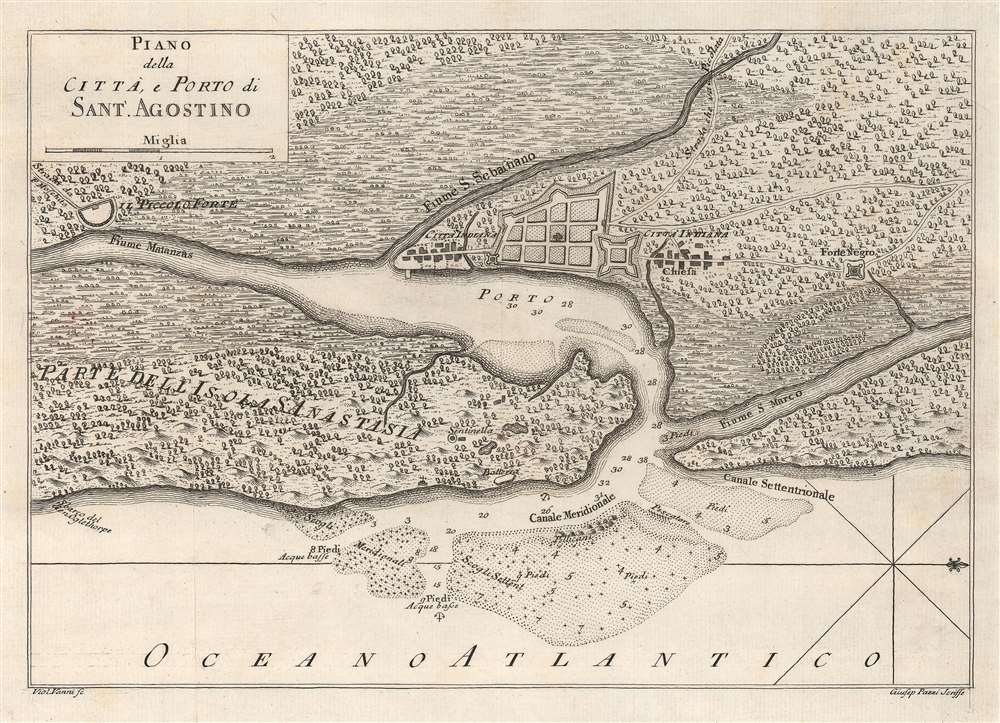
Piano della Città, e Porto di Sant.'Agostino.
1763 (undated) 8.125 x 11.5 in (20.6375 x 29.21 cm) 1 : 100000
1763 (undated) 8.125 x 11.5 in (20.6375 x 29.21 cm) 1 : 100000
Description
This is a c. 1763 Violante Vanni map of St. Augustine, Florida. Oriented to the east, St. Augustine appears above center with its walls and fort depicted. Two Native American settlements appear to the to the north and south of St. Augustine. Fort Mose, the first free Black settlement in what became the United States, is illustrated to the right (north) of St. Augustine, here labeled as 'Forte Negro'. Depth soundings with measurements appear along the 'Canale Meridionale' with several banks are illustrated.
Fort Mose
Fort Mose was the first free Black community in what is now the United States. Established in 1738 by order of the governor of Spanish Florida, Manuel de Montiano, Fort Mose housed fugitive slaves seeking freedom in Spanish Florida. King Charles II of Spain issued a 1693 decree that that any escaped slaves willing to convert to Catholicism and submit to four years of militia service would be granted asylum in Florida. Fort Mose was built two miles north of St. Augustine, Spanish Florida's capital, and served as a front line against potential British invasion. In 1740, during the War of Jenkins' Ear (1739 - 1748), British forces under Savannah founder James Oglethorpe invaded Florida and attacked St. Augustine. The Fort Mose militia fought alongside Spanish regulars, defeating Oglethorpe's force. They then participated in the unsuccessful 1742 Spanish counterattack into Georgia. When East Florida was ceded to the British following the 1763 Treaty of Paris, most residents of Fort Mose emigrated to Cuba with the evacuated Spanish.Publication History and Census
This map was drawn by Violante Vanni, engraved by Giuseppe Pazzi, and published c. 1763 in Il Gazzettiere Americano. Another edition was published c. 1777 in Atlante dell' America. We note nine examples of the present map cataloged in OCLC: Library of Congress, Florida State University, the University of Michigan, the Newberry Library, the Jacksonville Public Library, the University of California Berkeley, the British Library, the Klassik Stiftung Weimar / Herzogin Anna Amalia Bibliothek, and the Bayerische Staatsbibliothek. This map appears on the private market from time to time.Cartographer
Violante Vanni (1732 - c. 1776) was an Italian artist and engraver. Vanni is credited with being one of three people who wrote and illustrated Storia naturale degli uccelli trattata con metodo e adornata di figure intagliate in rame e miniate al naturale. Ornithologia methodice digesta atque iconibus aeneis ad vivum illuminatis, known as A Natural History of Birds in English. He also engraved at least one map of Saint Augustine that appeared in Il Gazzettiere americano in 1763 and Atlante dell'America in 1777. More by this mapmaker...
Condition
Very good. Light wear along original fold lines.
References
OCLC 5409514. Rumsey 14343.026 (1777). Tampa Bay History Center, Touchton Map Library,L2015.025.012.