This item has been sold, but you can get on the Waitlist to be notified if another example becomes available, or purchase a digital scan.
1924 Clason City Map or Plan of Santa Monica and Beverly Hills, California
SantaMonicaBeverlyHills-clason-1924$90.00

Title
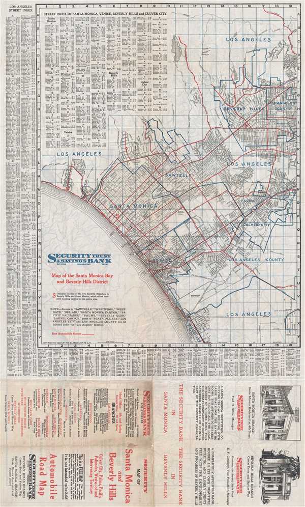
Map of Santa Monica Bay and Beverly Hills District.
1924 (dated) 28 x 17 in (71.12 x 43.18 cm) 1 : 42240
1924 (dated) 28 x 17 in (71.12 x 43.18 cm) 1 : 42240
Description
This is a 1924 Clason Map Company map of Santa Monica and Beverly Hills, California. The map depicts the region from Santa Monica Bay to Beverly Hills and Los Angeles County and from Los Angeles to Playa del Rey. Palms, Culver City, Sawtelle, and Venice are also labeled. Myriad streets are labeled throughout, with a street index of Santa Monica, Venice, Beverly Hills and Culver City situated in the upper left corner. The whole is framed bordered on both the left side and the bottom by a Los Angeles street index. Red lines overlaid on the map indicate the 'best automobile routes', while the thick blue lines appear to denote city and county borders. Advertising for the Security Trust and Savings Bank occupies the bottom quarter of the map, extolling the many convenient services that they provide.
This map was produced by the Clason Map Company in 1924 and printed for the Security Trust and Savings Bank of Santa Monica, California.
This map was produced by the Clason Map Company in 1924 and printed for the Security Trust and Savings Bank of Santa Monica, California.
Cartographer
George Samuel Clason (November 7, 1874 - 1957) was born in the city of Louisiana, Missouri in 1874. As a young man, Clason studied at the University of Nebraska before joining the United States Army in 1898 to fight in the Spanish American War. After the war, he moved to Denver, Colorado where in 1905 he founded the Clason Map Company, thus starting his lucrative publishing career. Clason initially focused on mining and mineral maps - capitalizing on the Colorado and Nevada mining industry, but quickly transitioned to railroad maps, city maps, and by the 1920s, road maps. As the company expanded, Clason opened a secondary office in Chicago, Illinois - then a rising map publishing center and railroad hub. At least one other satellite office was opened in Los Angeles. Among his many achievements, Clason is credited with producing the first modern road atlas of the United States. In the late 1920s, Clason also published a series of get-rich-quick pamphlets in the form of parables. The most famous of these is The Richest Man in Babylon. This tells the story of Arkad, a citizen of Babylon famed for his great wealth and generosity who shares his wit and wisdom with his fellow Babylonians. In 1949, Clason moved to Napa, California to retire and found a social club for retired gentlemen. More by this mapmaker...
Condition
Very good. Verso repairs of fold separations. Road map of the Greater Los Angeles region on verso