1959 Dustin Pictorial Map of Saranac Lake, the Adirondacks, New York
SaranacLakeAdirondacks-dustin-1959$350.00

Title
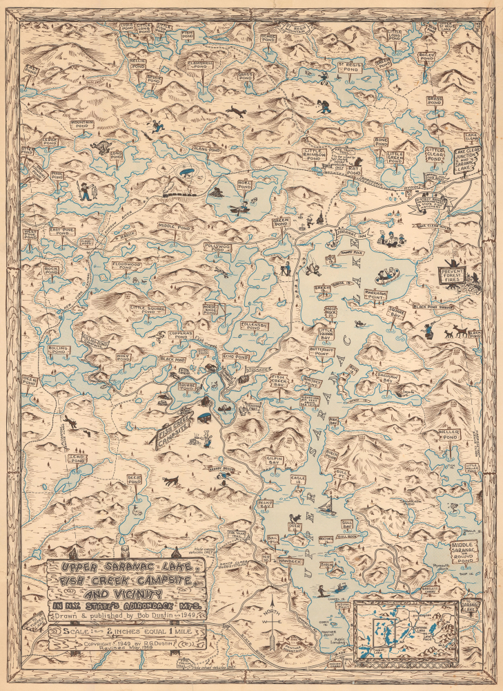
Upper Saranac Lake, Fish Creek Campsite, and Vicinity in N.Y. State's Adirondack Mts.
1959 (dated) 24.5 x 18 in (62.23 x 45.72 cm) 1 : 31680
1959 (dated) 24.5 x 18 in (62.23 x 45.72 cm) 1 : 31680
Description
This is a rare 1959 Robert G. Dustin pictorial map of Upper Saranac Lake and environs in the Adirondacks of New York. Upper Saranac Lake, home to the grand Saranac Inn, was long one of the main destinations in the vast and scenic wonderland of the Adirondacks.
A Closer Look
This map, reminiscent of the work of Jo Mora and Jolly Lindgren on Western parks and resort areas, covers Upper Saranac Lake and nearby bodies of water in the heavily forested wilderness of the Adirondacks. Aside from the titular lake, on the right, and Fish Creek Campsite, on the left, additional ponds, islands, mountains, accommodations, rail lines, roads (including fire roads), and other features are labeled throughout. Whimsical and sometimes humorous illustrations of humans and animals appear as well. An inset map at the bottom-right orients the area depicted in relation to the wider Adirondacks region, including Lake Placid and the town of Saranac Lake, to the east of the area seen here.The Saranac Inn
Among the features present here is the Saranac Inn at the north end of Upper Saranac Lake. The grand and sumptuous hotel was embellished over decades from a small guesthouse opened in 1864. In the process, it gained a reputation as the most luxurious accommodations in the region, with President Grover Cleveland maintaining a summer home there and President Chester A. Arthur being a frequent visitor. The hotel benefited greatly from the opening of the Mohawk and Malone Railway in 1892, linking with the New York Central and, in turn, New York City. A small town sprang up around the inn, offering services to travelers. In 1912, the Saranac Inn was completely rebuilt and expanded, but the hotel was severely hurt by the Great Depression and never fully recovered, closing in 1962 and mostly burning down in 1978. Nevertheless, a small town, a golf course, and a boat launch remain near where the hotel once stood.Publication History and Census
This map was prepared by Robert Gale Dustin in 1959, an update of an earlier 1949 edition of this map. It is related to another, equally rare contemporary map by Dustin titled 'Lower and Middle Saranac Lakes and Vicinity.' The only known institutional holdings of this map are the 1949 edition, held by the New York Public Library and the museum Adirondack Experience, and it is scarce to the market. Dustin also produced a 1977 pictorial map of the Saranac Lakes (previously sold by us as SaranacLakes-dustin-1977).Cartographer
Robert Gale Dustin (October 24, 1913 - November 16, 2001) was an American draftsman and cartographer. Born in Boscawen, New Hampshire, Dustin attended school in New Hampshire. He worked in Oak Ridge, Tennessee and Paducah, Kentucky, as the head of the drafting department for the Carbide Corporation. He married Emily Thompshon Heard on August 6, 1938, with whom he had at least two children. More by this mapmaker...
Condition
Good. Upper right corner reinstated, including parts of border. Several large repaired tears, including one extending from middle of map to upper border. Laid down on archival tissue. Stable.
References
OCLC 970660463. Adirondack Experience Library Control Number: 12884, Call Number: 1513.