1956 Byck Map of Savannah, Georgia
Savannah-byck-1956$350.00


Title
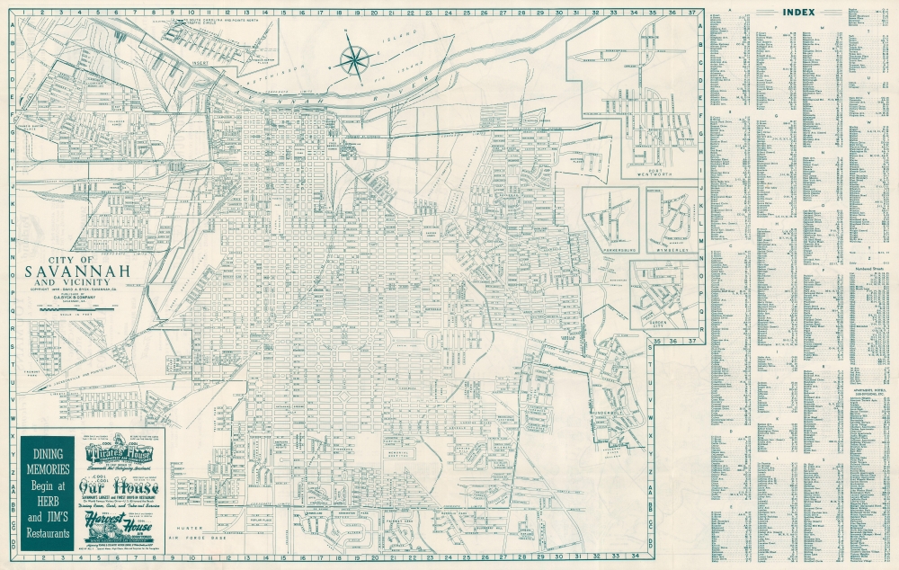
City of Savannah and vicinity.
1956 (dated) 20 x 26 in (50.8 x 66.04 cm) 1 : 14635
1956 (dated) 20 x 26 in (50.8 x 66.04 cm) 1 : 14635
Description
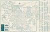
A large and detailed 1956 David Byck city map of Savannah, Georgia, with a map of Chatham County on the verso. It depicts the city in a period of transition while also alluding to its long history as one of the first non-indigenous settlements in the American South.
Among the neighborhoods noted is Yamacraw Village, a site fraught with historical significance. The area was so named for local Native Americans who originally inhabited a village at the site that became downtown Savannah. When Savannah was founded, they relocated to Yamacraw. Later, in the years before the American Civil War (1861 - 1865), the area became a haven for the socially marginalized, including freedmen and Jewish immigrants. After the Civil War, it remained a cultural center for African-Americans in Savannah, particularly as it contains the First Bryan Baptist Church, founded by freedman Andrew Bryan in 1794. Nearby on Bryan and Montgomery Streets is the First African Baptist Church, founded in 1773. Both churches are among the oldest and most important Black churches in the United States, and both can trace their origins to George Liele (c. 1750 - 1820), a freed slave who trained the missionaries, including Bryan, who formed the basis of the Black Baptist community in Savannah.
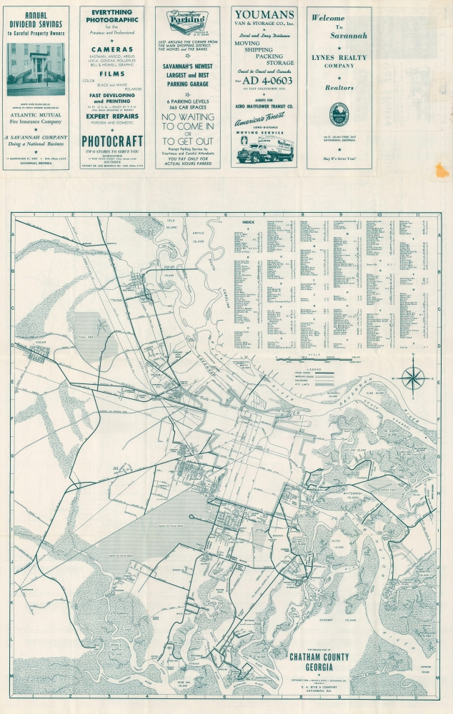
The verso map notes the presence of several airfields. Hunter Air Force Base (also noted at bottom-left on the recto). Like many cities in the South, in the postwar period, U.S. military bases became important to the local economy, while also impacting city life. The smaller Saffold Field was a short-lived pet project of businessman and aviation enthusiast Thomas Saffold, who owned the property and built an airfield on it in the mid-1940s. The county seized the property through eminent domain following a 1958 tax dispute. It was later used for public buildings. Travis Airfield towards the top-left later became Savannah-Hilton Head International Airport.
A Closer Look
Roads, railways, parks, cemeteries, hospitals, public buildings, and neighborhoods are noted throughout. An extensive index at right corresponds to the map grid. Five insets depict portions of the city beyond the scope of the map at west, as well as the suburbs of Port Wentworth, Parkersburg, Wymberley (Isle of Hope), and Garden City.Among the neighborhoods noted is Yamacraw Village, a site fraught with historical significance. The area was so named for local Native Americans who originally inhabited a village at the site that became downtown Savannah. When Savannah was founded, they relocated to Yamacraw. Later, in the years before the American Civil War (1861 - 1865), the area became a haven for the socially marginalized, including freedmen and Jewish immigrants. After the Civil War, it remained a cultural center for African-Americans in Savannah, particularly as it contains the First Bryan Baptist Church, founded by freedman Andrew Bryan in 1794. Nearby on Bryan and Montgomery Streets is the First African Baptist Church, founded in 1773. Both churches are among the oldest and most important Black churches in the United States, and both can trace their origins to George Liele (c. 1750 - 1820), a freed slave who trained the missionaries, including Bryan, who formed the basis of the Black Baptist community in Savannah.
The verso map notes the presence of several airfields. Hunter Air Force Base (also noted at bottom-left on the recto). Like many cities in the South, in the postwar period, U.S. military bases became important to the local economy, while also impacting city life. The smaller Saffold Field was a short-lived pet project of businessman and aviation enthusiast Thomas Saffold, who owned the property and built an airfield on it in the mid-1940s. The county seized the property through eminent domain following a 1958 tax dispute. It was later used for public buildings. Travis Airfield towards the top-left later became Savannah-Hilton Head International Airport.
Publication History and Census
This map was produced by David A. Byck and Company in 1956. Several other editions are cataloged in the OCLC as far back as 1935 and as late as 1968, though a 1956 edition is not listed among the holdings of any institution and is not known to have any history on the market.Condition
Very good.