
1861 Admiralty Civil War 'Blockade Runner' Map of the Savannah River, Georgia

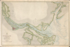
Savannah River Georgia From the United States Coast Survey 1855.
Savannah during Reconstruction.
- Digital Map Information
- Suitable for large format printing
- Full resolution TIFF file
- ICC color profile embedded
- Delivered instantly via download link
Savannah during Reconstruction.
This is an 1861 (1875-corrected) British Admiralty nautical map of the Savannah River and Calibogue Sound, combining prewar United States Coast Survey mapping with Civil War surveys and Reconstruction-era navigational updates. First published in 1861, the chart remained in service after the conflict, with successive corrections reflecting the practical needs of navigating Savannah's shoal-filled approaches.A Closer Look
Coverage extends from the Atlantic approaches off Tybee Island and Hilton Head westward to Savannah and upstream beyond Argyle Island. To the northeast, the chart follows Calibogue Sound between Daufuskie and Hilton Head islands to the May River. South of the Savannah River, it records Wilmington Island, McQueens Island, Tybee Island, and the intricate network of tidal waterways connecting them. The expanded coverage around Hilton Head and the May River, along with extensive hydrographic information, builds on the earlier survey's treatment of the harbor approaches. The paired range lights at Hague Point, now Haig Point, were installed in 1873 to guide vessels through Calibogue Sound.The navigational problem is immediately apparent: deep channels thread between extensive banks and isolated shoals, with breakers marking particularly dangerous approaches. Dense soundings, expressed in feet, distinguish usable water from surrounding shallows, while abbreviations identify the bottom's character. Buoys, beacons, anchorage symbols, tidal information, and three compass roses supply complementary guidance. At the river entrance, bearing lines lead past the offshore banks toward the lights on Tybee Island and the light vessel near the Knoll.
The Hague Point range lights provide an especially clear connection between the chart's revisions and contemporary maritime traffic. Both are marked on northeastern Daufuskie Island, with a line labeled Lights in line extending down Calibogue Sound. By aligning the two lights, a navigator could maintain the intended course between the sound's shoals. The lights were first exhibited on October 1, 1873; contemporary reports described this interior passage as serving passenger steamers between Charleston and Savannah as well as sailing vessels. Their appearance here records an improvement intended to make an established coastal route safer.
Savannah appears as a compact street grid beside its waterfront, opposite Hutchinson Island and immediately upstream from Fig Island. Field divisions, riverside buildings, wharves, and the Union Causeway place the port within its surrounding working landscape. Fort Jackson, Fort Pulaski, Fort Thunderbolt, and the fortified position at Caustens Bluff locate defenses alongside the channels they commanded. Green and olive washes distinguish land and marshes, pale blue emphasizes shallows, red picks out buildings and fortifications, and yellow draws attention to lights.
These defenses also preserve the chart's connection to the American Civil War (1861 - 1865). Fort Pulaski occupies Cockspur Island near the river entrance, opposite Tybee Island, from which Union batteries bombarded it on April 10 and 11, 1862. Its surrender strengthened the blockade of Savannah by placing this commanding position in Federal hands. The chart's acknowledgment of additions and corrections from an 1862 survey connects its hydrography to that wartime period, although the present impression incorporates later navigational information.
Publication History
The Admiralty in London first published the chart on July 1, 1861, under Hydrographer Captain John Washington (1800 - 1863), using United States Coast Survey work dated 1855. This example bears the fuller title Savannah River and Calibogue Sound and credits additions and corrections from a 1862 survey. The lower imprint records corrections in April 1866, while the marginal correction sequence continues through January 1875.The engraving is signed by J. and C. Walker. The retained sales imprint names J. D. Potter, agent for Admiralty charts, at 31 Poultry and 11 King Street, Tower Hill, London; the Hydrographic Office emblem above the title accompanies a printed price of half a crown.
Cartographers
The British Admiralty Office (1795 - Present), or the United Kingdom Hydrographic Office, is the Branch of the English government responsible for commanding the British Navy. In 1795, King George III created the United Kingdom Hydrographic Office, known as the U.K.H.O., to provide high-quality nautical charts for the Royal Navy. Before the Admiralty's founding, surveying and creating nautical charts was primarily a commercial venture, and the cartographer himself often financed the printing of his own material. Even the great navigator Cook is known to have scrambled for funds to publish his own seminal charts - the most important and advanced of the period. The system of privately funded nautical mapping and publishing left vast portions of the world uncharted and many excellent charts unpublished. King George III, responding to significant losses in trade revenue from shipwrecks and delays caused by poor charts, recognized the need for an institutionalized, government-sponsored cartographic agency: the Admiralty. The first head of the Admiralty, a position known as Hydrographer, was the important cartographer Alexander Dalrymple. Dalrymple began by organizing and cataloging available charts before starting the laborious process of updating them and filling in the blanks. The first official Admiralty Chart appeared in 1800 and detailed Quiberon Bay in Brittany. By 1808, Captain Thomas Hurd became Hydrographer. Hurd advocated selling Admiralty charts to the general public and, by the time he retired in 1829, had issued and published about 736 charts. Stewardship then passed to Rear Admiral Sir Francis Beaufort. Under Beaufort's administration, the Admiralty truly developed as a "chart-making" rather than a "chart-cataloging" institution. Beaufort held his post from 1829 to 1854. In his 25 years at the Admiralty, Beaufort created nearly 1,500 new charts and sponsored countless surveying and scientific expeditions, including the 1831 to 1836 voyage of the H.M.S. Beagle. By 1855, the Admiralty's chart catalog listed some 1,981 charts. Further Details...
The Office of the Coast Survey (1807 - present), founded in 1807 by President Thomas Jefferson and Secretary of the Treasury Albert Gallatin, is the oldest scientific organization in the U.S. Federal Government. Jefferson created the "Survey of the Coast," as it was then called, to produce accurate navigational charts of the new nation's coasts and harbors. The first two superintendents defined the spirit of the Coast Survey. The Coast Survey's first superintendent was Swiss immigrant and West Point mathematics professor Ferdinand Hassler. Under Hassler's direction, from 1816 to 1843, the Coast Survey established its ideological and scientific foundations. These included the use of the most advanced techniques and most sophisticated equipment, along with unstinting attention to detail. Hassler devised a labor-intensive triangulation system that divided the entire coast into a series of enormous triangles. These were then subdivided into smaller triangulation units, which were individually surveyed. No one had ever attempted this exacting technique on such a massive scale. As a result, Hassler and the Coast Survey under his leadership earned a reputation for uncompromising dedication to accuracy and excellence. Unfortunately, despite being a masterful surveyor, Hassler was abrasive and politically unpopular, and Congress cut funding for the Coast Survey twice. Nonetheless, Hassler led the Coast Survey until his death in 1843, when Alexander Dallas Bache, Benjamin Franklin's great-grandson, took the helm. Bache was fully dedicated to the principles established by Hassler, but proved more politically astute and successfully lobbied Congress to fund the endeavor generously. Under A. D. Bache's leadership, the Coast Survey completed its most important work. During his long tenure with the Coast Survey, from 1843 to 1865, Bache steadfastly advocated American science and navigation and, in fact, founded the American Academy of Sciences. Benjamin Pierce succeeded Bache and ran the Survey from 1867 to 1874. Pierce was succeeded by Carlile Pollock Patterson, Superintendent from 1874 to 1881. In 1878, under Patterson's superintendence, the U.S. Coast Survey was reorganized as the U.S. Coast and Geodetic Survey (USCGS) to accommodate both topographic and nautical surveys. Today, the Coast Survey is part of the National Oceanic and Atmospheric Administration (NOAA) as the National Geodetic Survey. Further Details...
Condition
Good. Some spotty foxing. Verso repairs to centerfold separations. Closed margin tears professionally repaired on verso. Closed tear extending 2 inches into printed area professionally repaired on verso.
References
OCLC 557395910. Trinkley, Michael, ed., Archaeological Investigations at Haig Point, Webb, and Oak Ridge, Daufuskie Island, Beaufort County, South Carolina, Research Series 15 (1989), p. 88. U.S. Coast Guard Historian's Office, Historic Light Station Information: South Carolina, pp. 2 - 3. National Park Service, 'Battle for Fort Pulaski'. Laughton, J. K., revised by R. O. Morris, 'Washington, John (1800 - 1863), naval officer and hydrographer', Oxford Dictionary of National Biography (2004; revised 2009).