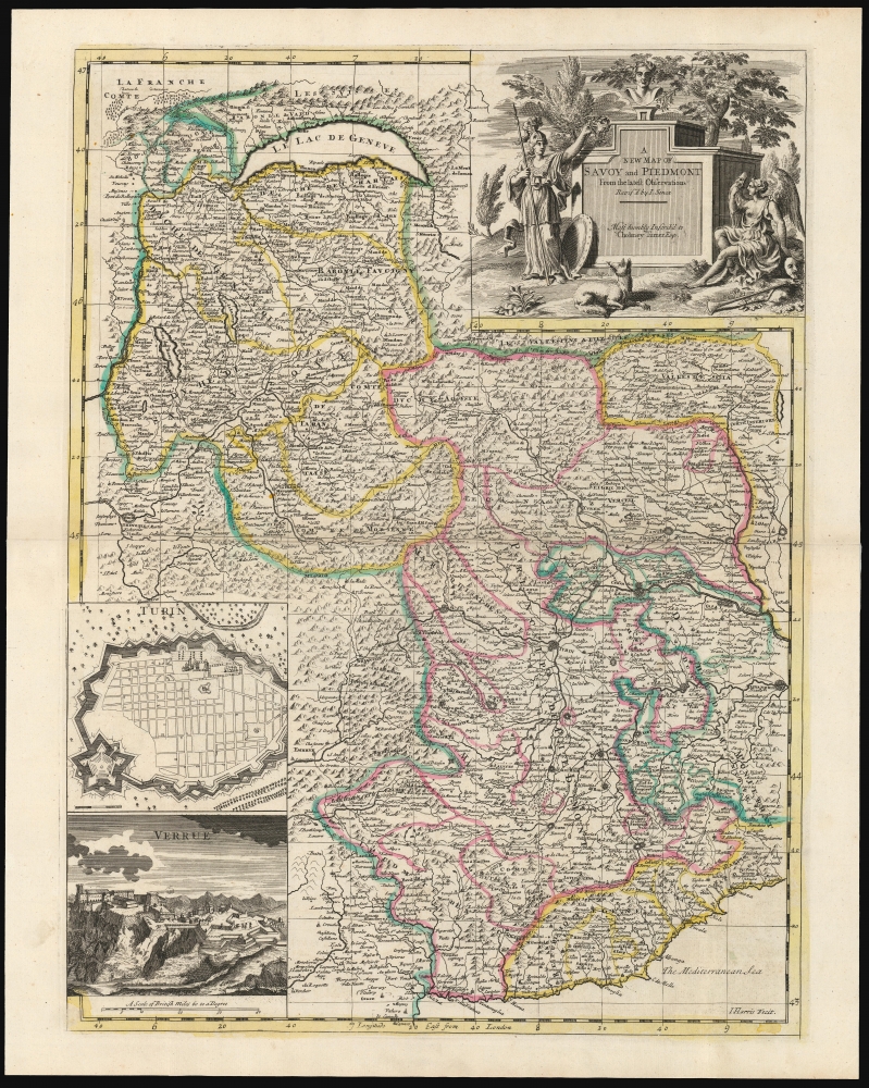
1721 Senex Map of the Duchy of Savoy and Principality of Piedmont
Savoy-senex-1721$850.00

Title
A New Map of Savoy and Piedmont From the latest Observations Revis'd by I. Senex.
1721 (undated) 21.75 x 16.25 in (55.245 x 41.275 cm) 1 : 862000
1721 (undated) 21.75 x 16.25 in (55.245 x 41.275 cm) 1 : 862000
Description
This is John Senex's 1721 map of the Duchy of Savoy and the Principality of Piedmont. The map is retrospective, illustrating the region in the wake of the War of the Spanish Succession (1701 - 1714). Coverage extends from Lake Geneva and Switzerland in the north to Nice and the Mediterranean Sea in the south, including parts of Dauphiné and Provence, and part of the Duchy of Milan to the east.
The map depicts the region's mountainous terrain pictorially (oddly, a portion of the mountains of eastern Provence appear to be unfinished). The original outline color delineating the complex borders of this frontier region is carefully applied with a high degree of consistency, based on examples we have been able to compare - indicating the importance of these borders at the time this map was produced. While retrospective to the War of the Spanish Succession, this map was produced during the War of the Quadruple Alliance (1718 - 1720). This conflict - notable for being one of the only instances in the 18th century in which France and Britain were allied - was caused by Spain's attempts to recapture territory in Italy lost due to the 1713 Treaty of Utrecht. While the fighting took place mainly in Sicily and Spain, Savoy was party to the conflict, and had the conflict progressed differently may well have become a theatre of war.
The cartouche is surmounted with a bust wearing laurels: contextually, this may represent Eugene or Savoy. The helmeted woman to the left, with the spear, is certainly Minerva (Goddess of wisdom in war); she presents another laurel to Savoy, acknowledging the Duchy's clever maneuvering during the late war. The winged lady seated to the right of the cartouche is probably Fame (her trumpet is lying at her feet). Interestingly, Fame holds a mask to her face, while several more lie on the ground behind her close to hand: a reference, probably, to Savoy's willingness to shift allegiances. Savoy's faithlessness to France may also be alluded to by the dog in the foreground. An icon of loyalty, this pooch seems to be throwing Minerva a look of affront as though offended by the means by which the Duchy came to earn her laurels.
Historical Context
The map was printed in 1721, reflecting the state of affairs following the War of the Spanish Succession (1701 - 1714). At the beginning of that war, Savoy and France were allies. When Savoy changed sides, France invaded. The arrival of Austrian troops led by the celebrity general, Prince Eugene of Savoy, turned the French at the Siege of Turin. (The importance of that siege is the reason for the inset plan of that fortified city.) Similarly, the inset view of the Fortezza di Verrua Savoia in the lower left commemorates the failed French siege of the fort in 1704.The map depicts the region's mountainous terrain pictorially (oddly, a portion of the mountains of eastern Provence appear to be unfinished). The original outline color delineating the complex borders of this frontier region is carefully applied with a high degree of consistency, based on examples we have been able to compare - indicating the importance of these borders at the time this map was produced. While retrospective to the War of the Spanish Succession, this map was produced during the War of the Quadruple Alliance (1718 - 1720). This conflict - notable for being one of the only instances in the 18th century in which France and Britain were allied - was caused by Spain's attempts to recapture territory in Italy lost due to the 1713 Treaty of Utrecht. While the fighting took place mainly in Sicily and Spain, Savoy was party to the conflict, and had the conflict progressed differently may well have become a theatre of war.
A Telling Cartouche
In the upper right is an elegant title cartouche (with also a somewhat meager dedication to 'Cholmey Turner, Esq.,' a British Whig politician sitting in the House of Commons).The cartouche is surmounted with a bust wearing laurels: contextually, this may represent Eugene or Savoy. The helmeted woman to the left, with the spear, is certainly Minerva (Goddess of wisdom in war); she presents another laurel to Savoy, acknowledging the Duchy's clever maneuvering during the late war. The winged lady seated to the right of the cartouche is probably Fame (her trumpet is lying at her feet). Interestingly, Fame holds a mask to her face, while several more lie on the ground behind her close to hand: a reference, probably, to Savoy's willingness to shift allegiances. Savoy's faithlessness to France may also be alluded to by the dog in the foreground. An icon of loyalty, this pooch seems to be throwing Minerva a look of affront as though offended by the means by which the Duchy came to earn her laurels.
Publication History and Census
The map was engraved by John Harris for Senex's 1721 A New General Atlas. It is scarce and is listed in only three institutional collections: The National Library of Wales, the Bayerische Staatsbibliothek, and the University of Alabama. The Atlas is well represented in institutional collections.CartographerS
John Senex (1678 - 1740) was an English engraver and map maker active in London during the first half of the 18th century. Senex was born to upper middle class parents in Shropshire, England. As a young man, he was apprenticed to Robert Clavell, a London bookseller and member of the Stationers' Company, under whom he mastered the arts of engraving and printmaking. Around 1702 Senex completed his apprenticeship and established himself as a printer and bookseller in the Strand. A year later Senex partnered with Jeremiah Seller and Charles Price, the successors to the important mapmaker John Seller, and relocated to Cornhill. This was likely Senex's first introduction to mapmaking though he seems to have taken to it with abandon. In the subsequent years Senex established himself as one of the most prominent cartographers in London, publishing a number of beautiful and important maps that today rank among the finest examples from the Golden Age of British Cartography. In addition to a large corpus of flat maps, Senex also produced a number of important and highly desirable globes. Eventually Senex dissolved his partnership with Seller and Price and relocated to Fleet Street, where he maintained offices until his death in 1740. Senex was succeeded by his widow, Mary Senex, who continued to publish and update his works until about 1755, when the remaining globe and map plates were sold to James Ferguson. More by this mapmaker...
John Harris (fl. 1686 – 1730) was a British cartographer, engraver and draughtsman active in London during the late 17th and early 18th centuries. Harris is believed to have been born in Northamponshire but little else is certain regarding his personal life as 'John Harris' was an exceedingly common name be 17th century London. Nonetheless, his known work includes engravings for Philip Lea, Robert Morden, Herman Moll, and others. Learn More...
Source
Senex, John A New General Atlas (London: Browne) 1721.
Condition
Excellent. Generous margins and a bold strike with original outline color.
References
OCLC 1119838271. Rumsey 10014.122.