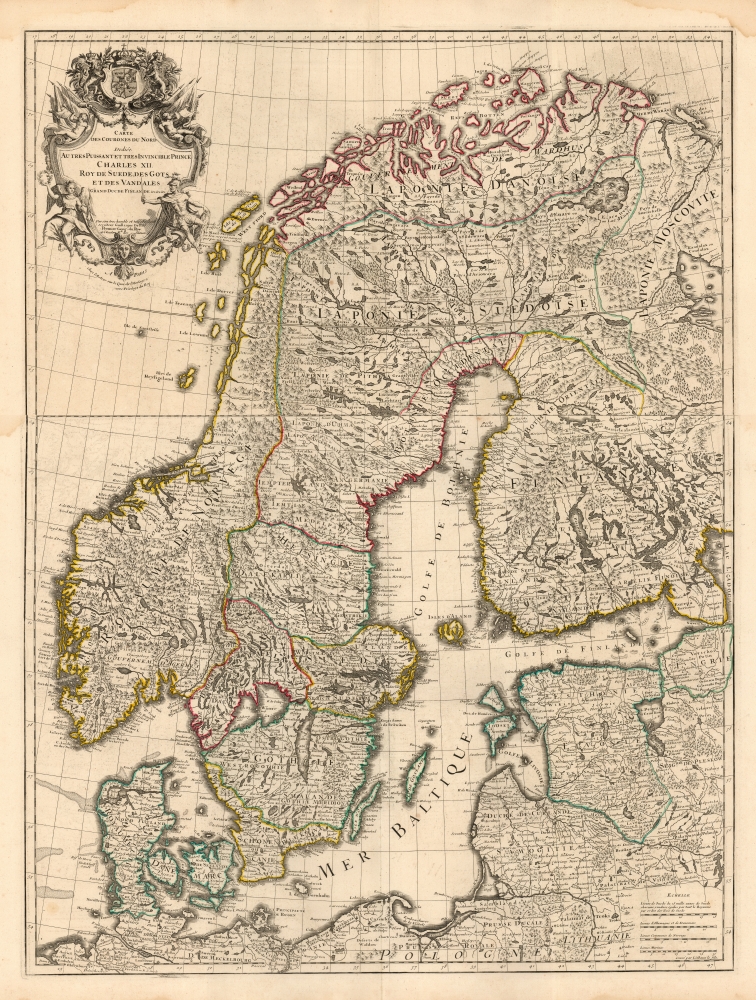
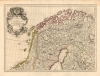
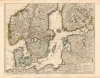
1718 De l'Isle map of Scandinavia and the Swedish Empire
Scandinavia-delisle-1718$1,250.00

Title
Carte des Courones du Nord Dediée au tres puissant et tres invincible Prince Charles XII, Roy de Suede, des Gots et des Vandales, Grand Duc de Finlande etc, etc, etc. Par son tres humble et tres obeissant serviteur Guillaume De l'Isle Premier Geogr. du Roy de l'Academ. Rle. des Sciences.
1718 (undated) 32.5 x 24.5 in (82.55 x 62.23 cm) 1 : 2600000
1718 (undated) 32.5 x 24.5 in (82.55 x 62.23 cm) 1 : 2600000
Description
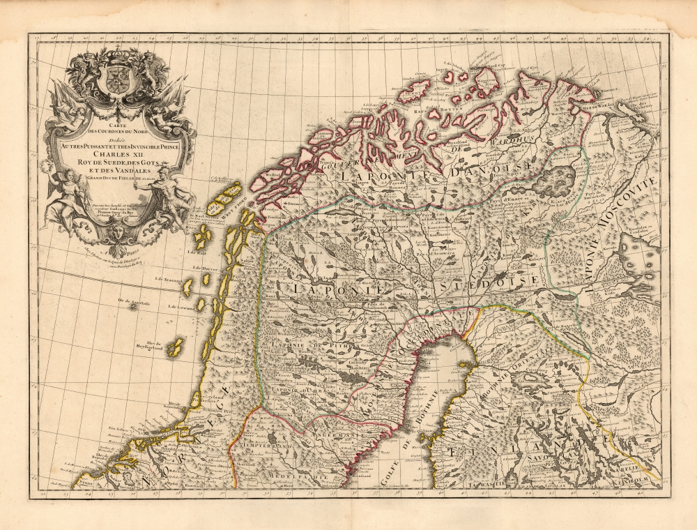
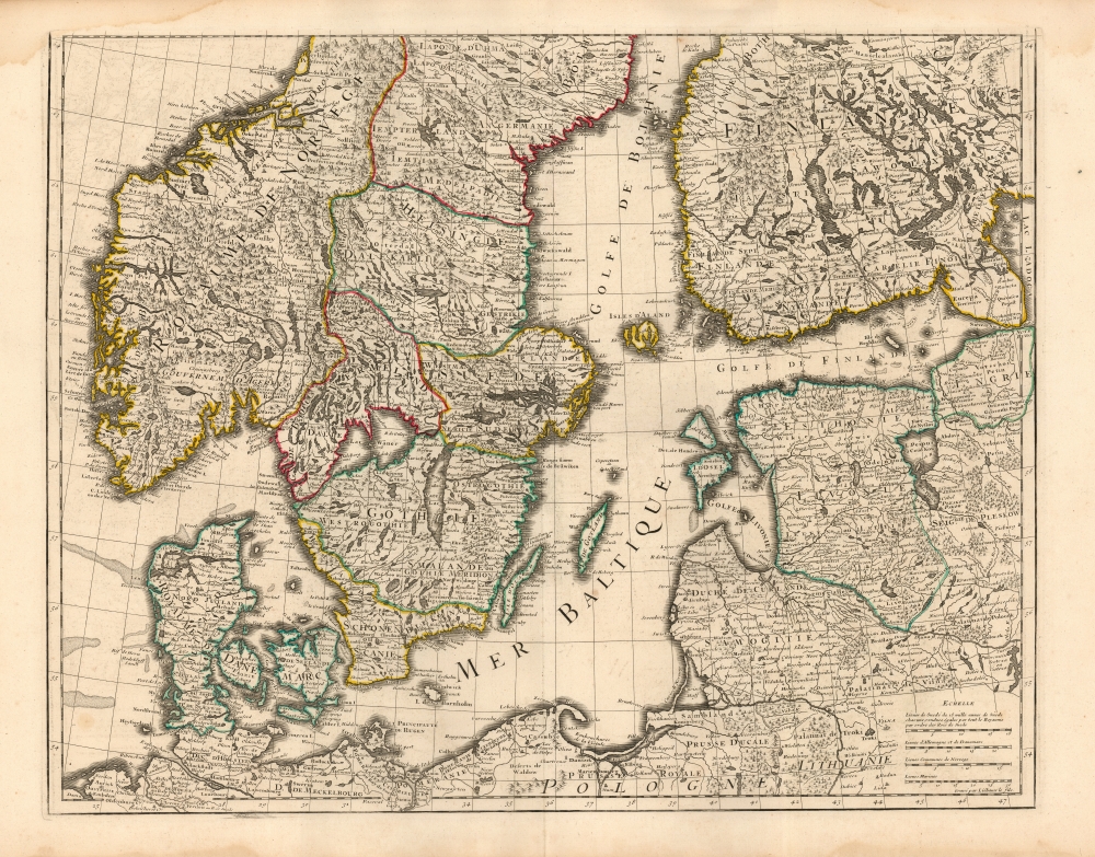
This is Guillaume de l'Isle's magnificent 1706 two-sheet map of Scandinavia, highlighting the empire of King Charles XII of Sweden. It captures the Kingdom of Sweden during the last reign of its 'Age of Greatness' at the height of the Great Northern War (1700 - 1721). The map further illustrates the degree to which early cartographers struggled to keep pace with evolving political events. The image above is a composite, but the map is in two separate sheets - as apparent in the subsequent photos.
Things were never again as good for Sweden. In 1707, Charles invaded Russia and gained another victory at the Battle of Holowczyn, but the necessity of leaving significant forces in defensive roles sapped the strength he could direct eastward. Instead of moving to take Saint Petersburg, Charles pushed towards Moscow, and everything began to go wrong. By the time he arrived at the siege of Poltava in July 1709, Charles had been wounded, with a third of his infantry dead and no supply train. His broken army was unable to move the fortified, modern Russian army defending the city. 'The very powerful and very invincible Prince Charles XII' escaped to the Ottoman Empire with a small entourage, and the rest of his army surrendered days later.
Scope
The map comprises all of modern Sweden, Norway, Denmark, and western Finland. The southern sheet in particular includes Estonia, Livonia, and Lithuania, extending as far south as to include part of Poland and the Duchy of Prussia. The opening of the Nieve River shows the cities of Noteburg and Nyskanz, but St. Petersburg does not appear. The upper sheet reaches as far south as 62º north, and the southern sheet reaches as far north as 64º, allowing overlap should the two sheets be joined. The lack of a finished map border to the top of the southern sheet suggests that the two were designed for such joining (we see a joined example in the Bibliothèque Nationale, with the join at 64º) although evidently, colorists did not always get that memo.Great Northern War (1700 - 1721)
The map is prominently dedicated to King Charles XII of Sweden 'the very powerful and very invincible Prince Charles XII King of Sweden, Gots and Vandals,' which serves to indicate the speed with which world events could overtake the best efforts of cartographers to record them. When this map was engraved, Sweden's war with Russia and her allies - the Great Northern War - had been underway for six years. Russia invaded Swedish-held Livonia and Estonia, but Charles' counterattack at the 1700 Battle of Narva led to a shocking Russian defeat. Rather than pressing the Russians, Charles instead moved against neutral Poland-Lithuania, swiftly defeating the Polish king Augustus II and his Saxon allies at the 1702 Battle of Kliszow. He replaced Augustus as king of the Polish-Lithuanian Commonwealth with the puppet Stanisław Leszczyński. The map's detail reflects the state of affairs at this high point in Charles' reign, but misses an important development: in 1703 Russian forces penetrated Ingria, and established the new city of Saint Petersburg - these incursions are not shown here.Things were never again as good for Sweden. In 1707, Charles invaded Russia and gained another victory at the Battle of Holowczyn, but the necessity of leaving significant forces in defensive roles sapped the strength he could direct eastward. Instead of moving to take Saint Petersburg, Charles pushed towards Moscow, and everything began to go wrong. By the time he arrived at the siege of Poltava in July 1709, Charles had been wounded, with a third of his infantry dead and no supply train. His broken army was unable to move the fortified, modern Russian army defending the city. 'The very powerful and very invincible Prince Charles XII' escaped to the Ottoman Empire with a small entourage, and the rest of his army surrendered days later.
Publication History and Census
This map was engraved by Henri Liébaux for Guillaume De l'Isle. The first state of the map was issued in 1706 with both De l'Isle's imprint and that of Amsterdam printer Louis Renard. That partnership was short-lived, as a second state has the date intact but Renard's imprint burnished out. A newly-engraved Amsterdam edition of the map, printed by Pieter Schenk and dated 1708, appears to explain the removal of Renard from the picture. In the present example, the date is removed but De l'Isle's is named 'Premier Geographe du Roy', suggesting a date of c. 1718. De l'Isle's heirs, Buache and Dezauche, later reprinted the map under their own imprints, in 1745 and 1780, respectively. A 1742 Covens and Mortier edition was completely re-engraved to new plates with very different geography, especially in the southern plate. We see three examples of this state listed in OCLC.Cartographer
Guillaume De l’Isle (1675 - 1726) was a French cartographer, and arguably the finest mapmaker at the beginning of the eighteenth century. He was the son of Claude De L'Isle (1644 -1720), a Paris-based historian and geographer under Nicholas Sanson, then the leading light of French cartography. He was the chief proponent of the school of 'positive geography' and the primary figure defining the heights of the Golden Age of French Cartography. Guillaume's skill as a cartographer was so prodigious that he drew his first map at just nine years of age. He was tutored by J. D. Cassini in astronomy, science, mathematics and cartography. By applying these diverse disciplines to the vast stores of information provided by 18th century navigators, Guillaume created the technique that came to be known as 'scientific cartography', essentially an extension of Sanson's 'positive geography'. This revolutionary approach transformed the field of cartography and created a more accurate picture of the world. Among Guillaume's many firsts are the first naming of Texas, the first correct map of the Mississippi, the final rejection of the insular California fallacy, and the first identification of the correct longitudes of America. Stylistically De L'Isle also initiated important changes to the medium, eschewing the flamboyant Dutch style of the previous century in favor of a highly detailed yet still decorative approach that yielded map both beautiful and informative. Guillaume was elected to the French Academie Royale des Sciences at 27. Later, in 1718, he was also appointed 'Premier Geographe du Roi', an office created especially for him. De L'Isle personally financed the publication of most of his maps, hoping to make heavy royalties on their sales. Unfortunately he met an untimely death in 1728, leaving considerable debt and an impoverished child and widow. De L'Isle's publishing firm was taken over by his assistant, Phillipe Buache, who would also become his son in law. More by this mapmaker...
Condition
Very good. Two separate sheets, unjoined, with complete margins. Marginal water staining, else excellent with original outline color.
References
OCLC 717444343. Rumsey 4764.009 and 4764.010.