This item has been sold, but you can get on the Waitlist to be notified if another example becomes available, or purchase a digital scan.
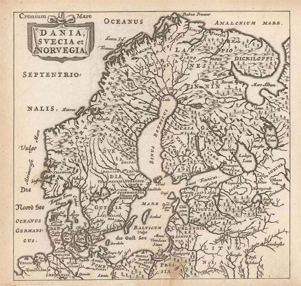
1661 Elzevir / Cluver map of Scandinavia
Scandinavia-elzevir-1661$87.50

Title
Dania, Suecia et Norvegia.
1661 (undated) 4.75 x 5 in (12.065 x 12.7 cm) 1 : 16800000
1661 (undated) 4.75 x 5 in (12.065 x 12.7 cm) 1 : 16800000
Description
This is a finely-engraved miniature map of Scandinavia, printed in a 1661 Elzevir edition of Philipp Cluver's introduction to geography, appearing in editions produced by many different houses, and with maps of wildly differing characteristics. This map follows the model of Swedish mathematician and cartographer Anders Bure, whose 1624 map of Scandinavia - the first geodetically correct map of the region - provided the basis for virtually every general map of the region, including those by Goos, Hondius, and Blaeu, from whose work this one is almost certainly derived.
A Mystery Engraver? A Woman?
None of the maps appearing in the Elzevir edition of Cluver's Introductionis in universam geographiam are signed by an engraver. For a miniature map, this is not unusual - very often this work was executed by journeyman engravers, who would not have the right to apply their imprint to the work. However, it is very possible that the matriarch of the Elzevir firm - Eva van Alphen - did this work herself. She is known to have been an accomplished engraver, having been credited with a beautiful Dutch Bible map after Visscher (Orbis Terrarum Tabula Recens Emendata et in Lucem Edita per N. Visscher). At the time that their edition of Cluver was produced, Eva's husband Jean was in failing health and upon his 1661 death she took over the direction of the firm. The excellent work here may well be hers.Publication History and Census
The map was engraved for inclusion in Philipp Cluver's Introductionis in universam geographiam. Though he did not live to see it in print, Cluver's text would be one of the most popular of the seventeenth century, which was printed in many editions starting in 1624 but continuing well into the 18th century. This example appeared in a 1661 edition of the book, published by the house of Elzevir.CartographerS
Anders Bure (August 14, 1571 - February 4, 1646) was a Swedish mathematician and cartographer. He is considered the father of Swedish cartography. He was the son of the parish priest Engelbertus Laurentii and Elisabeth Andersdotter Burea, descendant of the long-established Bureätten family. His immediate family included diplomats and government officials. His education is obscure, though he is mentioned as an office clerk in 1602. His duties in the following years involved recording royal genealogical and historical works, involving him in the highest echelons of Swedish society. He also participated in diplomatic assignments, including missions to both Russia and Finland. His cartographic contributions improved the mapping both of the northern parts of Sweden, and the kingdom as a whole. His six-sheet 1626 Orbis Arctoi represented the first real improvement to the mapping of the northern parts of Europe since the Olaus Magnus map of the previous century: this map would provide the basis for virtually every European map of Scandinavia to follow in the 17th century. In addition to these achievements, he was the first person recorded to use the decimal system in Sweden. More by this mapmaker...
Philipp Clüver (also Klüwer, Cluwer, or Cluvier, Latinized as Philippus Cluverius and Philippi Cluverii) (1580 - December 31, 1622) was a German geographer and historian active in Leiden in the late 16th and early 17th centuries. Clüver was born in the Royal Prussian city of Danzig (Gdansk), then a province of the Kingdom of Poland. He study of law at the University of Leiden before turning his attention to history and geography. Cluver traveled, mostly by foot, extensively throughout Europe, spending time in Germany, England, Scotland, Holland and Italy. On returning to Leiden he was given a special appointment as geographer and put in charge of the university's library. Cluver is best known for his general study of the geography of antiquity. A popular Enlightenment era field of study, antiquarian geography attempted to resolve place names known from classical literature but, by the time of the Renaissance, geographically confused. Cluver based his research not only on classical literary sources, but — and this was his primary contribution to the genre — also his extensive and local inspections of sites. Today he is considered one of the founding fathers of historical geography. Cartographically Cluver's most prominent works include his edition of Ptolemy's Geographia (based on Mercator's edition of 1578) and for miniature atlases that were reprinted for most of the 17thand 18th centuries. Cluver was also known as Klüwer, Cluwer, or Cluvier, Latinized as Philippus Cluverius and Philippi Cluverii. He died in Leiden in 1622. Learn More...
Petrus Bertius (November 14, 1565 – October 12, 1629), also known as Peter Bardt and P. Bertii, was a Flemish theologian, historian, and cartographer. Bertius was born in Beveren (Alveringem), a son of the preacher Pieter Michielszoon Bardt. The Bardt family fled to London at the outbreak of the Dutch War of Independence in 1568, fleeing both religious and political strife. When the political situation in the Netherlands stabilized in 1577, Bertius returned to study at the University of Leiden. He supported himself by tutoring until 1593 when he was appointed subregent of the Leiden Statencollege. This was probably a nepotistic post as, in the same year, he married Maritgen Kuchlinus, the daughter of Johannes Kuchlinus, then regent of the Statencollege. Bertius himself succeeded Johannes, becoming regent in 1606. Through his marriage, Bertius associated with Flemish cartographers Jodocus Hondius and Pieter van den Keere, both of whom were in-laws. Bertius first began publishing cartographic works in 1598 when, working with Barent Langenes, he published a the miniature Latin language atlas Tabulae contractae. In 1618, publishing with his brother-in-law Jodocus Hondius, he issued the atlas Theatrum Geographiae Veteris, which impressed Louis XIII of France sufficiently that he relocated to Paris to take position as court cosmographer to the King. Two years later he converted to Catholicism and took a position teaching rhetoric at the Collège de Boncourt, in Paris. In 1622, Louix XIII granted him a chart in mathematical sciences at the royal college and the honorarium of royal historian. Bertius remained in Paris until his death in 1629. Learn More...
The house of Elzevir (active c. 1600 - 1712) were a celebrated family of Dutch booksellers, publishers, and printers of the 17th and early 18th centuries; their specialty tended to be small - format 'duodecimo' books. The firm came to prominence with the work of Lodweijk, or Louis, Elzevir (1546-1617) who got his start as a bookbinder in Leuven and after some years became a bookseller and publisher in is own right in Leiden. Louis published about 150 works during his lifetime. He had seven sons, five of whom carried on their father's trade. Of these, Bonaventura Elzevir (1583–1652) is the most celebrated. He began publishing in 1608, joined in 1626 by his nephew Abraham Elzevir (1592-1652). In 1617 another nephew, Isaac Elzevir (1596–1651), acquired a press allowing the family business to take over the production end of the publishing process. Abraham's son Jean Elzevir (1622-1661) joined the partnership in 1647; he would carry on the Leiden business until his death in 1661. Jean's wife, Eva van Alphen Elzevier (active 1651-1663; died 1681) then became head of the business, producing work of a very high quality. Bonaventura's son Daniel. (1626-80) would join his cousin Louis' press in Amsterdam in 1654, but many of their productions were actually manufactured at Eva's press in Leyden. It is likely that the quality work of this period can be credited to her: it dropped sharply after her death in 1681, at which point the business fell into the hands of her feckless son Abraham, whose incompetence brought the company to an end with his own death in 1712. Learn More...
Source
Clüver, P. Philippi Cluverii Introductionis in Universam Geographiam(Amsterdam: Elzevir) 1661.
Condition
Very good. Faint stain at bottom center, else an attractive, sharp image.
References
Not in OCLC.