This item has been sold, but you can get on the Waitlist to be notified if another example becomes available, or purchase a digital scan.
1747 Bowen Map of Scandinavia (Norway, Sweden, Finland and Denmark)
Scandinavia2-bowen-1747$250.00

Title
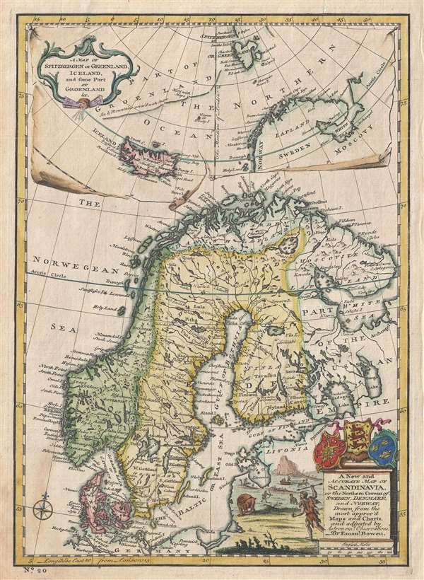
A New and Accurate Map of Scandinavia or the Northern Crowns of Sweden, Denmark and Norway. A Map of Spitzbergen or Greenland, Iceland and some part of Groenland etc.
1747 (undated) 13 x 9.5 in (33.02 x 24.13 cm) 1 : 9300000
1747 (undated) 13 x 9.5 in (33.02 x 24.13 cm) 1 : 9300000
Description
This is a fascinating 1747 map of Scandinavia by the British cartographer Emanuel Bowen. It covers Denmark, Norway, Sweden, Finland (shown as part of Sweden) and parts of the Russian Empire. The map notes several towns, cities, rivers, lakes, islands, roads and a host of additional topographic features. Mountains are beautifully rendered in profile.
The Lofoten Maelstrom
Of particular interest is cartographer's depiction of the legendary Lofoten Maelstrom (Maalstrom) in northwestern Norway. This legendary whirlpool was the inspiration for Edgar Allen Poe's classic short story Descent into the Maelstrom. In reality, it is a periodic and powerful current caused by tidal variations in the region.
A large inset in the top of the map proper includes a map of Iceland, Spitzbergen (Svalbard) and parts of Greenland. When this map was issued, the coasts of Greenland were fairly well mapped out by Icelandic and Scandinavian whalers, but here, due to turbulent waters, is remains vague.
The map identifies Cape Hold-with-Hope or Kap Broer Ruys and the rest of Greenland's east coast is noted as 'Ice and mountains covered with snow'. Iceland had been fairly well mapped since the late 16th century and this map illustrates its four primary provinces.
A title cartouche with beautifully illustrated hunters is included in the lower right quadrant. The coat of arms of Norway, Denmark and Sweden are also included above the title. This map was prepared by Emanuel Bowen as plate no. 25 for the 1747 issue of A Complete System of Geography.
Cartographer
Emanuel Bowen (1694 - May 8, 1767) had the high distinction to be named Royal Mapmaker to both to King George II of England and Louis XV of France. Bowen was born in Talley, Carmarthen, Wales, to a distinguished but not noble family. He apprenticed to Charles Price, Merchant Taylor, from 1709. He was admitted to the Merchant Taylors Livery Company on October 3, 1716, but had been active in London from about 1714. A early as 1726 he was noted as one of the leading London engravers. Bowen is highly regarded for producing some of the largest, most detailed, most accurate and most attractive maps of his era. He is known to have worked with most British cartographic figures of the period including Herman Moll and John Owen. Among his multiple apprentices, the most notable were Thomas Kitchin, Thomas Jeffreys, and John Lodge. Another apprentice, John Oakman (1748 - 1793) who had an affair with and eventually married, Bowen's daughter. Other Bowen apprentices include Thomas Buss, John Pryer, Samuel Lyne, his son Thomas Bowen, and William Fowler. Despite achieving peer respect, renown, and royal patronage, Bowen, like many cartographers, died in poverty. Upon Emanuel Bowen's death, his cartographic work was taken over by his son, Thomas Bowen (1733 - 1790) who also died in poverty. More by this mapmaker...
Source
Bowen, E., A Complete System of Geography. Being a description of all the countries, islands, cities, chief towns, harbours, lakes, and rivers, mountains, mines, etc., of the known world …, (London) 1747.
Condition
Very good. Original platemark visible. Blank on verso. A few minor verso repairs and reinforcements to margins.
References
Rumsey 3733.024. Philips (atlases) 614 (1752 edition).