This item has been sold, but you can get on the Waitlist to be notified if another example becomes available, or purchase a digital scan.
1595 Mercator's Two-Sheet Map of Scotland
Scotiae-mercator-1595$1,000.00


Title
Scotiae regnum.
1595 (undated) 22 x 18 in (55.88 x 45.72 cm) 1 : 1000000
1595 (undated) 22 x 18 in (55.88 x 45.72 cm) 1 : 1000000
Description
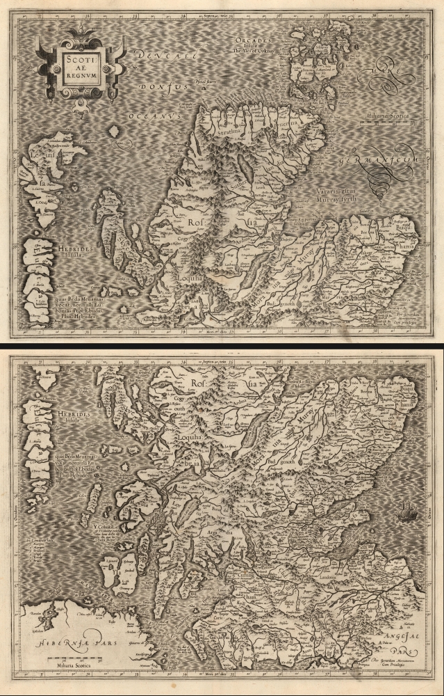
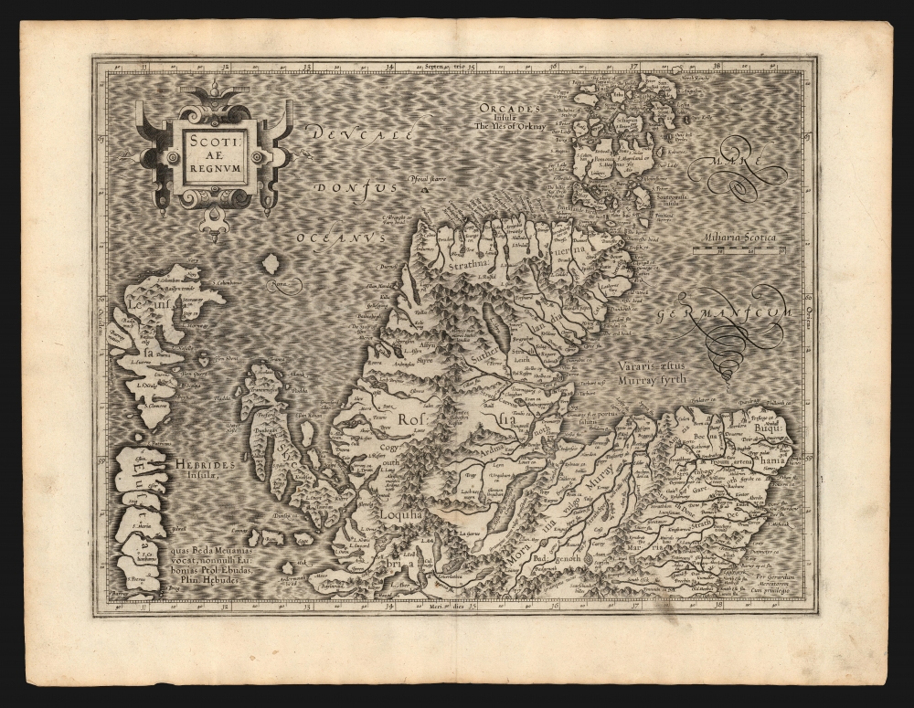
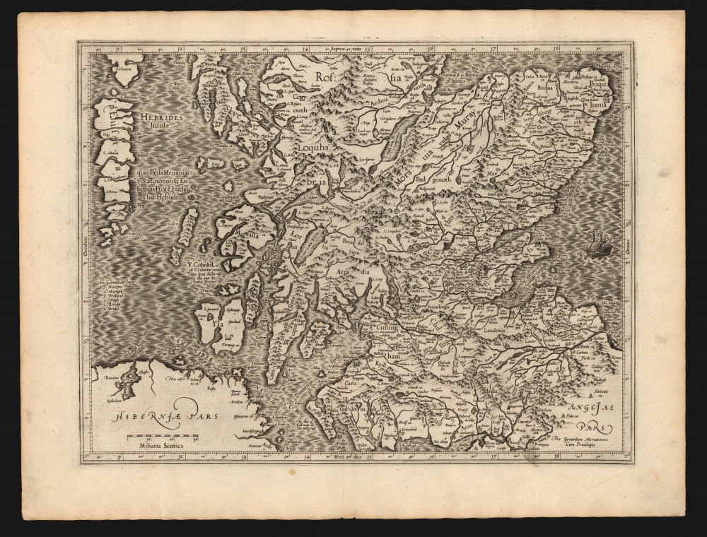
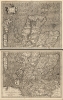
This is a superb 1595 first-edition of Gerard Mercator's 2-sheet map of Scotland. Mercator's mapping replaced all earlier representations of Scotland, and while the details of Mercator's single-sheet Scotia Regnum agree with this one, the greater area afforded this two-sheet map permit the inclusion of much more detail. So while this and the smaller map clearly share the same source, the present work was able to present its information in the most complete form of what Rodney Shirley would declare, 'this was to remain the standard outline, apart from minor improvements by Speed, until a new map of Scotland by Robert Gordon was published in 1654'.
Sources
Ortelius' Scotiae Tabula, the first atlas map specifically of Scotland, had been based faithfully on the mapping of Scotland in Mercator's 1564 eight-sheet map of England, Scotland, and Ireland. Mercator's wall map was derived from a manuscript drawn by an unidentified English friend, and his data for Scotland appears to have suffered accordingly. The present work is much revised, with a great many material corrections suggesting a different if unknown source. A cursory glance at the Orkney Islands on Mercator's atlas map reveals differences between this and the 1564 map. Further scrutiny on the Upper Firth of Clyde ('Dumbritan Fyrth') and the vicinity of Loch Lomond, for example, will show more accurate and recognizable place names than appear on the earlier maps. Whomever produced the source for Mercator's revisions to the present map was more familiar with Scottish geography than the person informing his earlier work. In many places, Mercator uses local terminology in explicit contradiction of accepted placenames; such corrections would have required local expertise that his earlier work had not benefited from. In addition to presenting more vernacular place names, the map includes more notation than does the single-sheet; For example, it is noted that neither Loch Ness nor the River Ness ever freezes.Scope of the Map
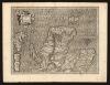
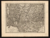
The map is printed to two sheets, with some overlap between them. The upper sheet covers the north part of Scotland, from Redcastle in the southeast up to include the Orkney Islands; the map extends west to include the Hebrides, from South Uist to include Lewis. The lower sheet spans from Whithorne and Carlisle in the south up to Balnagall, Skye, and the southern tip of Lewis island in the Orkneys. The southwest part of the map includes the Northeast coast of Ireland.In Mercator's Own Hand
Although his atlas was published posthumously by Mercator's heirs, this is among the maps engraved personally by the master. This is a superb example of his work. Scotland's rugged terrain is evocatively, if pictorially represented. Even the smallest lettering engraved here is clear, fine, and legible. Mercator's innovation in the application of Italic letters to differentiate town names from regional ones is evident throughout. Bold shading sets off the coastlines, both for the oceans and the inland bodies of water. The broad expanses of hachured ocean afford Mercator the opportunity for some beautiful calligraphic flourishes. The map's title, and its appended scales in Scottish miles, are contained in an elegant strapwork cartouche also characteristic of Mercator's compositions.Publication History and Census
These map were engraved by Gerard Mercator, but were not published until 1595 by his heirs in the posthumous Atlas sive Cosmographicae. They were included in editions of the Mercator / Hondius atlas without change until 1636, at which point Mercator's imprint was removed, and Henry Hondius' imprint added to the southern sheet. Thereafter Hondius replaced the maps with an entirely new work. The typography of the verso text on our example conforms to the 1595 first edition of the Mercator atlas. The map is well represented in institutional collections in its later editions. One example of the pair assigned a 1595 date is listed in OCLC at the Universitatsbibliothek Eichstatt.Cartographer
Gerard Mercator (March 5, 1512 - December 2, 1594) is a seminal figure in the history of cartography. Mercator was born near Antwerp as Gerard de Cremere in Rupelmonde. He studied Latin, mathematics, and religion in Rupelmonde before his Uncle, Gisbert, a priest, arranged for him to be sent to Hertogenbosch to study under the Brothers of the Common Life. There he was taught by the celebrated Dutch humanist Georgius Macropedius (Joris van Lanckvelt; April 1487 - July 1558). It was there that he changed him name, adapting the Latin term for 'Merchant', that is 'Mercator'. He went on to study at the University of Louvain. After some time, he left Louvain to travel extensively, but returned in 1534 to study mathematics under Gemma Frisius (1508 - 1555). He produced his first world map in 1538 - notable as being the first to represent North America stretching from the Arctic to the southern polar regions. This impressive work earned him the patronage of the Emperor Charles V, for whom along with Van der Heyden and Gemma Frisius, he constructed a terrestrial globe. He then produced an important 1541 globe - the first to offer rhumb lines. Despite growing fame and imperial patronage, Mercator was accused of heresy and in 1552. His accusations were partially due to his Protestant faith, and partly due to his travels, which aroused suspicion. After being released from prison with the support of the University of Louvain, he resumed his cartographic work. It was during this period that he became a close fried to English polymath John Dee (1527 - 1609), who arrived in Louvain in 1548, and with whom Mercator maintained a lifelong correspondence. In 1552, Mercator set himself up as a cartographer in Duisburg and began work on his revised edition of Ptolemy's Geographia. He also taught mathematics in Duisburg from 1559 to 1562. In 1564, he became the Court Cosmographer to Duke Wilhelm of Cleve. During this period, he began to perfect the novel projection for which he is best remembered. The 'Mercator Projection' was first used in 1569 for a massive world map on 18 sheets. On May 5, 1590 Mercator had a stroke which left him paralyzed on his left side. He slowly recovered but suffered frustration at his inability to continue making maps. By 1592, he recovered enough that he was able to work again but by that time he was losing his vision. He had a second stroke near the end of 1593, after which he briefly lost speech. He recovered some power of speech before a third stroke marked his end. Following Mercator's death his descendants, particularly his youngest son Rumold (1541 - December 31, 1599) completed many of his maps and in 1595, published his Atlas. Nonetheless, lacking their father's drive and genius, the firm but languished under heavy competition from Abraham Ortelius. It was not until Mercator's plates were purchased and republished (Mercator / Hondius) by Henricus Hondius II (1597 - 1651) and Jan Jansson (1588 - 1664) that his position as the preeminent cartographer of the age was re-established. More by this mapmaker...
Source
Mercator, G., Atlas sive Cosmographicae, (Duisberg) 1595.
Mercator's Atlas is one of the most important works in the history of cartography. Although in fact Ortelius was the first to publish a proper atlas, the Teatrum Orbis Terrarum, Mercator's work the first book to employ the term Atlas for a collection of maps. The term is derived both from the mythical titan, Atlas, who was forced to bear the world upon his shoulders, and the Libyan king, philosopher, and astronomer of the same name that, so the legend goes, constructed the first globe. Mercator dedicated the final 25 years of his life to compile the Atlas. He published two parts during his lifetime in 1585 and 1589, but the final part published posthumously by his son Rumold Mercator, in 1595. The map plates for the Atlas were later acquired by Jodocus Hondius who published the most complete and well known edition in 1606. It was Jodocus who popularized the Atlas and who did the most to elevate Gerard Mercator's name.
Condition
Excellent. Few areas of soiling; marginal mends not impacting printed image. Each separate image approximately 13.75 x 18 inches respectively; measurement above given for printed image if joined.
References
OCLC 633643750. Rumsey 10501.091, 10501.088 (1607) an der Krogt, P., Koeman's Atlantes Neerlandici, 5801:1.1, 5802:1.1