This item has been sold, but you can get on the Waitlist to be notified if another example becomes available, or purchase a digital scan.
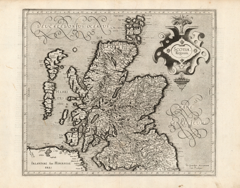
1595 Mercator Map of Scotland (First Edition)
Scotland-mercator-1595$625.00

Title
Scotia, Regnum.
1595 (undated) 13.75 x 16 in (34.925 x 40.64 cm) 1 : 1900000
1595 (undated) 13.75 x 16 in (34.925 x 40.64 cm) 1 : 1900000
Description
This is a superb 1595 first-edition of Gerard Mercator's map of Scotland. It is the second printed map specifically of Scotland to appear in an atlas, the first being the 1573 Ortelius Scotiae Tabula. This present map, however, replaced all earlier representations of Scotland. Rodney Shirley observed that 'this was to remain the standard outline, apart from minor improvements by Speed, until a new map of Scotland by Robert Gordon was published in 1654'.
Sources
Ortelius' Scotiae Tabula was based faithfully on the mapping of Scotland in Mercator's 1564 eight-sheet map of England, Scotland, and Ireland. Mercator's wall map was derived from a manuscript drawn by an unidentified English friend, and his data for Scotland appears to have suffered accordingly. The present work is much revised, with a great many material corrections suggesting a different if unknown source. A cursory glance at the Orkney Islands on Mercator's atlas map reveals differences between this and the 1564 map. Further scrutiny on the Upper Firth of Clyde ('Dumbritan Fyrth') and the vicinity of Loch Lomond, for example, will show more accurate and recognizable place names than appear on the earlier maps. Whomever produced the source for Mercator's revisions to the present map was more familiar with Scottish geography than the person informing his earlier work.Scope of the Map
The southern limit of the map encloses the River Tyne and Hadrian's Wall, here termed Murus Pictius, the Pictish Wall. As such, part of the northeastern coast of Ireland is shown as well, but that island's detail is here restricted to the coastline with the result that the eye is not distracted from the detail of the primary focus of the map. The map is sufficiently broad to include both the Hebrides and the Orkney Islands.In Mercator's Own Hand
Although his atlas was published posthumously by Mercator's heirs, this is among the maps engraved personally by the master. This is a superb example of his work. Scotland's rugged terrain is evocatively, if pictorially represented. Even the smallest lettering engraved here is clear, fine, and legible. Mercator's innovation in the application of Italic letters to differentiate town names from regional ones is evident throughout. Bold shading sets off the coastlines, both for the oceans and the inland bodies of water. The broad expanses of stippled ocean to the northwest and to the east afford Mercator the opportunity for some beautiful calligraphic flourishes. The map's title, and its appended scales in Scottish miles, are contained in an elegant strapwork cartouche also characteristic of Mercator's compositions.Publication History and Census
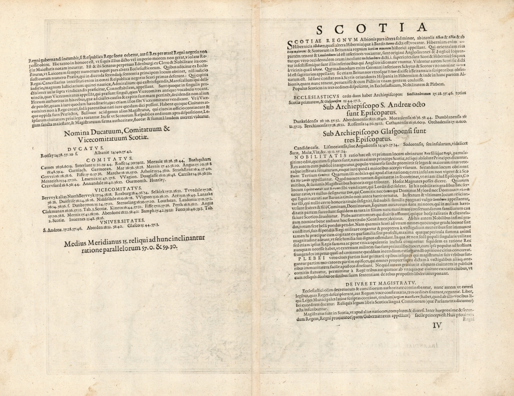
This map was engraved by Gerard Mercator after 1585, but was not published until 1595 by his heirs in the posthumous Atlas sive Cosmographicae. It was included in editions of the Mercator / Hondius atlas without change until 1636, at which point Mercator's imprint was removed. Thereafter Jansson replaced the map in his editions of the atlas with a new plate. The typography of the verso text on our example conforms to the 1595 first edition of the Mercator atlas. The map is well represented in institutional collections in its later editions. Ten examples assigned a 1595 date are listed in OCLC.Cartographer
Gerard Mercator (March 5, 1512 - December 2, 1594) is a seminal figure in the history of cartography. Mercator was born near Antwerp as Gerard de Cremere in Rupelmonde. He studied Latin, mathematics, and religion in Rupelmonde before his Uncle, Gisbert, a priest, arranged for him to be sent to Hertogenbosch to study under the Brothers of the Common Life. There he was taught by the celebrated Dutch humanist Georgius Macropedius (Joris van Lanckvelt; April 1487 - July 1558). It was there that he changed him name, adapting the Latin term for 'Merchant', that is 'Mercator'. He went on to study at the University of Louvain. After some time, he left Louvain to travel extensively, but returned in 1534 to study mathematics under Gemma Frisius (1508 - 1555). He produced his first world map in 1538 - notable as being the first to represent North America stretching from the Arctic to the southern polar regions. This impressive work earned him the patronage of the Emperor Charles V, for whom along with Van der Heyden and Gemma Frisius, he constructed a terrestrial globe. He then produced an important 1541 globe - the first to offer rhumb lines. Despite growing fame and imperial patronage, Mercator was accused of heresy and in 1552. His accusations were partially due to his Protestant faith, and partly due to his travels, which aroused suspicion. After being released from prison with the support of the University of Louvain, he resumed his cartographic work. It was during this period that he became a close fried to English polymath John Dee (1527 - 1609), who arrived in Louvain in 1548, and with whom Mercator maintained a lifelong correspondence. In 1552, Mercator set himself up as a cartographer in Duisburg and began work on his revised edition of Ptolemy's Geographia. He also taught mathematics in Duisburg from 1559 to 1562. In 1564, he became the Court Cosmographer to Duke Wilhelm of Cleve. During this period, he began to perfect the novel projection for which he is best remembered. The 'Mercator Projection' was first used in 1569 for a massive world map on 18 sheets. On May 5, 1590 Mercator had a stroke which left him paralyzed on his left side. He slowly recovered but suffered frustration at his inability to continue making maps. By 1592, he recovered enough that he was able to work again but by that time he was losing his vision. He had a second stroke near the end of 1593, after which he briefly lost speech. He recovered some power of speech before a third stroke marked his end. Following Mercator's death his descendants, particularly his youngest son Rumold (1541 - December 31, 1599) completed many of his maps and in 1595, published his Atlas. Nonetheless, lacking their father's drive and genius, the firm but languished under heavy competition from Abraham Ortelius. It was not until Mercator's plates were purchased and republished (Mercator / Hondius) by Henricus Hondius II (1597 - 1651) and Jan Jansson (1588 - 1664) that his position as the preeminent cartographer of the age was re-established. More by this mapmaker...
Source
Mercator, G., Atlas, sive Cosmographicæ meditationes de fabrica mundi et fabricati figura, (Duisberg: Busius) 1595.
Condition
Excellent. Few stains away from image, else fine with a bold strike and generous margins.
References
OCLC 276672361. Rumsey 10501.085 (1607) Van der Krogt, P. C. J., Koeman's Atlantes Neerlandici, (Vol. 1), 5800:1A.1. Karrow, R. W., Mapmakers of the Sixteenth Century and their Maps 56/145.