This item has been sold, but you can get on the Waitlist to be notified if another example becomes available, or purchase a digital scan.
1844 Steel and Norie Blueback Chart or Map of the Coast of Scotland
Scotland-steelnorie-1844$875.00

Title
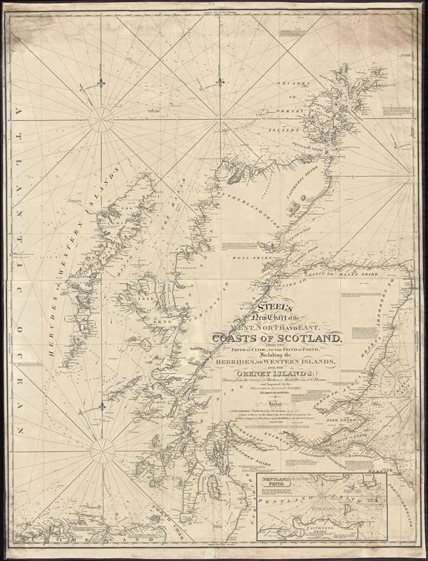
Steel's New Chart of the West, North, and East Coasts of Scotland from the Frith of Clyde to the Frith of Forth, Including the Hebrides, or Western Islands, and the Orkney Islands.
1844 (dated) 50 x 39 in (127 x 99.06 cm) 1 : 425000
1844 (dated) 50 x 39 in (127 x 99.06 cm) 1 : 425000
Description
This is an 1844 David Steel and John William Norie nautical chart or maritime map of the coasts of Scotland. The chart depicts the region from the Atlantic Ocean to Fair Island, Aberdeenshire, and the Murray Bank and from the Orkney Island to Northumberland, Ayreshire, and Ireland. Highly detailed, myriad depth soundings are indicated throughout. Counties within Scotland are labeled, along with several Lochs (including Loch Ness). Numerous firths along the Scottish coast are also illustrated in detail. Cities, towns, villages, and other locations are labeled all along the coast, including Aberdeen, Montrose, Dundee, Perth, Stirling, and Glasgow. Castle Urquhart is also labeled along the coast of Loch Ness. An inset map of Pentland Firth is situated along the bottom border. Lighthouses are labeled throughout the map and indicated by red and yellow manuscript notations. Information concerning each of these lighthouses is present as well, providing details about each lighthouse's functionality.
Blueback Charts
Blueback nautical charts began appearing in London in the late 18th century. Bluebacks, as they came to be called, were privately published large format nautical charts known for their distinctive blue paper backing. The backing, a commonly available blue manila paper traditionally used by publishers to warp unbound pamphlets, was adopted as a practical way to reinforce the low-quality paper used by private chart publishers in an effort to cut costs. The earliest known blueback charts include a 1760 chart issued by Mount and Page, and a 1787 chart issued by Robert Sayer. The tradition took off in the early 19th century, when British publishers like John Hamilton Moore, Robert Blachford, James Imray, William Heather, John William Norie, Charles Wilson, David Steel, R. H. Laurie, and John Hobbs, among others, rose to dominate the chart trade. Bluebacks became so popular that the convention was embraced by chartmakers outside of England, including Americans Edmund March Blunt and George Eldridge, as well as Scandinavian, French, German, Russian, and Spanish chartmakers. Blueback charts remained popular until the late 19th century, when government subsidized organizations like the British Admiralty Hydrographic Office and the United States Coast Survey, began issuing their own superior charts on high quality paper that did not require reinforcement.Publication History and Census
This chart was produced by John William Norie in 1844, updating David Steel's plate. All examples are exceedingly rare.CartographerS
David Steel, Senior (1734 - 1799) was a British chart publisher, engraver, instrument-seller, bookseller, bookbinder, and vendor of patent medicines. The son of a William Steel, a bookbinder, he apprenticed in the firm founded by Mount and Page. He married Ann Beauchamp in 1776. He began publishing nautical charts in 1782. His business was founded on the publication of his own technical nautical works and the list of the Royal Navy. The firm owned a navigation warehouse and opened a navigation school in 1799. Following his father’s death, David Steel, Junior (1763 - 1803) took over the family business until his untimely death at the age of 39. Steel, Junior, first began working at the Navy Office, before leaving that position to study law. He worked a a practicing barrister for several years, until the death of his father. David married Penelope Winde on May 1, 1786. They had five children together. An obituary for David Steel, Junior, in the Steel publication Navy List states that 'of his character it may be said, that his ideas were most enlarged, his mind capacious and richly cultivated; his principles generous and manly; his eloquence nervous and impressive.' After David Steel Junior's untimely death, his wife Penelope took over the family business, and marries William Mason in 1806, with whom she continued the business. She moved the firm to 70 Cornhill in 1809 from Union Row, Tower Hill. By 1810 the supply of new charts had ceased, and John Purdy, who had apprenticed with David Steel, Senior, left the firm to work with Laurie and Whittle, the Steel's competitors. By 1814, Penelope Steel had entered into a business partnership with Stanley Goddard, a younger man, who would become her third husband, and renamed the firm Steel and Goddard. By June 1819, Goddard and the firm were bankrupt, and J. W. Norie and Company acquired the 'case fixtures, stock in trade and copper plates' from the firm. More by this mapmaker...
John William Norie (June 3, 1772 - December 24, 1843) was a British teacher of navigation, hydrographer, chart maker, and publisher of maritime manuals active in London, England in the late 18th and early 19th centuries. Norie was born in Wapping, London, an area long associated with the maritime sciences. Norie's career as a chart maker commenced under the tutelage of William Heather, a prominent purveyor and publisher of nautical charts, pilot books, and navigational tools who took over the firm of Mount and Page in 1765. Heather and Norie were likely acquainted through John Hamilton Moore, another important chart maker with whom both seem to have been associated early in their careers. Heather hired Norie to teach basic navigation at his shop at 157 Leadenhall Street. Under Heather Norie also distinguished himself as a draftsman, completing many of the early charts associated with the Heather firm. When Heather died in 1812 John Norie partnered with George Wilson, a moneyed 'man about town' with little experience in the maritime trades, to acquire the map and chart business at 9500 British Pounds. It proved a good deal for Norie, who retained all copyright privileges and drew 1/4 quarter share of business profits, as well an impressive quarterly salary and, for doing all of the work, 1/3rd of Wilson's share. The firm, referred to as the 'Naval Warehouse' quickly acquired a reputation for quality navigational materials and became a favorite of merchant seamen. It was even referenced in Charles Dickens' classic novel Dombey and Son. In 1819, Norie and Wilson acquired the failing chart business of David Steel, which significantly increased the size, though not quality, of their chart catalogue. With the rise of the British Admiralty and its own maritime chart productions, the business of "Chart Purveyor" in London dramatically changed. Admiralty charts and pilot books, designed for military use, were offered through established intermediaries, like Norie, at bargain prices. Most chart makers of the period found it profitable to use the highly technical Admiralty charts to update their own more decorative vernacular charts. For a brief time this practice proved exceptionally profitable but eventually began to draw criticism. Nonetheless, Norie retired to Edinburgh in 1840 and died a wealthy man in 1843. In 1840 the business passed to a nephew of George Wilson, Charles Wilson, who renamed the firm "Norie & Wilson". William Heather Norie, J. W. Norie's own son, produced few charts, instead pursuing a career in the legal field. Norie & Wilson merged with James Imray's prosperous chart business in 1899, becoming Imray, Laurie, Norie & Wilson, a profitable concern that remains active in the maritime charting industry. Learn More...
Condition
Very good. Full professional restoration. Large tear through the center of the map that has been professionally repaired. Blank on verso.
References
OCLC 13781697.