This item has been sold, but you can get on the Waitlist to be notified if another example becomes available, or purchase a digital scan.
1793 Wilkinson Map of Scotland
Scotland-wilkinson-1792$100.00

Title
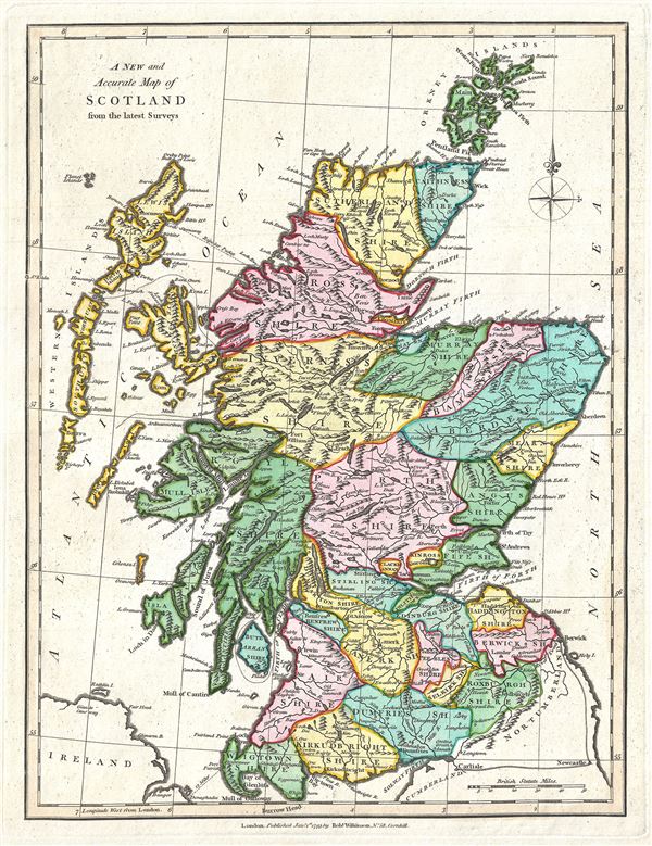
A New and Accurate Map of Scotland from the latest Surveys.
1793 (dated) 12 x 9.5 in (30.48 x 24.13 cm) 1 : 1900000
1793 (dated) 12 x 9.5 in (30.48 x 24.13 cm) 1 : 1900000
Description
This is a finely detailed 1793 map of Scotland by Robert Wilkinson. Wilkinson's map covers Scotland in full from the Cheviot Hills to the Orkney Island and from the Outer Hebrides (Western Islands) to Aberdeenshire. Color coding divides the region into various counties with roads, lochs, cities, and rivers noted. Here all the counties are labeled as Shires, as the word 'county' did not become common usage in Scotland until the nineteenth century.
In the north are Caithness, Sutherland, Ross, Murray, Aberdeen, and Bamff Shires. With the exception of the merger of Ross Shire and Cromarty Shire, these counties are still in existence today. In central Scotland are the Inverness Shire, Mearns Shire, Angus Shire, Argyle Shire, Fife Shire and Perth Shire. Further south are the Shires of Stirling, Linlithgow, Renfew, Dumbarton, Edinburgh, Haddington, Berwick, Lanerk, Air, Kirkudbright, Dumfries, Selkirk, Wigtown and Roxburgh. South of Lewis Island is North and South Uist Island, and Coll Island, which retained baronial fief by the Macleans of Coll until 1848. In the northeast are the Shetland Islands, which did not officially become a part of Scotland until a Scottish Act of Parliament in 1669.
This map was engraved by Thomas Conder and issued as plate no. 11 in the 1792 edition of Robert Wilkinson's General Atlas.
CartographerS
Robert Wilkinson (fl. c. 1758 - 1825) was a London based map and atlas publisher active in the late 18th and early 19th centuries. Most of Wilkinson's maps were derived from the earlier work of John Bowles, one of the preeminent English map publishers of the 18th century. Wilkinson's acquired the Bowles map plate library following that cartographer's death in 1779. Wilkinson updated and retooled the Bowles plates over several years until, in 1794, he issued his first fully original atlas, The General Atlas of the World. This popular atlas was profitably reissued in numerous editions until about 1825 when Wilkinson died. In the course of his nearly 45 years in the map and print trade, Wilkinson issued also published numerous independently issued large format wall, case, and folding maps. Wilkinson's core cartographic corpus includes Bowen and Kitchin's Large English Atlas (1785), Speer's West Indies (1796), Atlas Classica (1797), and the General Atlas of the World (1794, 1802, and 1809), as well as independent issue maps of New Holland (1820), and North America ( 1823). Wilkinson's offices were based at no. 58 Cornhill, London form 1792 to 1816, following which he relocated to 125 Frenchurch Street, also in London, where he remained until 1823. Following his 1825 death, Wilkinson's business and map plates were acquired by William Darton, an innovative map publisher who reissued the General Atlas with his own imprint well into the 19th century. More by this mapmaker...
Thomas Conder (1747 - June 1831) was an English map engraver and bookseller active in London during the late 17th and early 18th centuries. From his shop at 30 Bucklersbury, London, Conder produced a large corpus of maps and charts, usually in conjunction with other publishers of his day, including Wilkinson, Moore, Kitchin, and Walpole. Unfortunately few biographical facts regarding Conder's life have survived. Thomas Conder was succeeded by his son Josiah Conder who, despite being severely blinded by smallpox, followed in his father's footsteps as a bookseller and author of some renown. Learn More...
Source
Wilkinson, R., A General Atlas being A Collection of Maps of the World and Quarters the Principal Empires, Kingdoms, etc. with their several Provinces, and other Subdivisions, Correctly Delineated, (London) 1792.
Condition
Very good. Original platemark visible. Blank on verso.
References
Rumsey 1201.010 (1794 edition).