1856 Kuchel amd Dresel Bird's-Eye View of Scotts Bar and French Bar, California
ScottsBarFrenchBar-kucheldresel-1856$8,000.00

Title
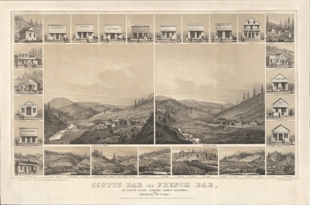
Scotts Bar and French Bar, on Scotts River, Siskiyou County, California.
1856 (dated) 18.5 x 28 in (46.99 x 71.12 cm)
1856 (dated) 18.5 x 28 in (46.99 x 71.12 cm)
Description
A remarkable 1856 two-color chromolithograph bird's-eye view of California gold mining boomtowns Scotts Bar and French Bar, Siskiyou County, California. The view reveals these boomtowns on Scotts River - a 60-mile-long tributary of the Klamath River - at the height of the Northern California Gold Rush. Today, they are both ghost towns.
Scott's Bar was named after John W. Scott, who discovered placer gold there in 1850, marking it as the first gold discovery in the Siskiyou Mountains. It was a particularly rich strike and was actively prospected until the mid-20th century. Even so, the town never grew into a city. Today, there is an eco-lodge there, as well as a post office, but little else, despite its scenic beauty and the occasional panned nugget.
City views were being produced in the United States as early as the 1830s, but the genre exploded after the American Civil War (1861 - 1865). Bridging the gap between maps and pictures, most 19th century American bird's-eye views presented cities to the public from highpoints. Some were imagined, but others were drawn from hot-air balloons or nearby hills. The presentation, combining high elevation, commercial interest, and new printing technology, created a uniquely American art form, as described by historian Donald Karshan,
Scotts Bar
The lefthand view illustrates Scotts Bar, the first gold strike in California's northern mining area. The town sits on high ground above the Scotts River, where numerous wheels channel water into sluices. Above and to the left of the view are illustrations of local businesses, ranging from hotels to livery stables, carpenters, saloons, and even a French restaurant and bakery.Scott's Bar was named after John W. Scott, who discovered placer gold there in 1850, marking it as the first gold discovery in the Siskiyou Mountains. It was a particularly rich strike and was actively prospected until the mid-20th century. Even so, the town never grew into a city. Today, there is an eco-lodge there, as well as a post office, but little else, despite its scenic beauty and the occasional panned nugget.
French Bar / La Grange
This righthand view illustrated French Bar, here in its second iteration after the earlier camp flooded out. This French Bar sits above the floodplain. In the foreground, Scotts River has numerous waterwheels designed to carry water to a sluice for gold extraction. The surrounding hills give ample evidence of lumbering, littered with fallen and stripped trees. When this view was drawn, French Bar had about 100 buildings and a small Chinatown. Above and to the right of the view are illustrations of local businesses, including offices, hotels, express stops, and more.Mining Scenes
At the base of the view are several fascinating mining scenes illustrating the elaborate sluice works. Each view represents a specific claim, with the owners named below.Chromolithography
Chromolithography, sometimes called oleography, is a color lithographic technique developed in the mid-19th century. The process involved using multiple lithographic stones, one for each color, to yield a rich composite effect. Oftentimes, the process would start with a black basecoat upon which subsequent colors were layered. Some chromolithographs used 30 or more separate lithographic stones to achieve the desired product. Chromolithograph color could also be effectively blended for even more dramatic results. The process became extremely popular in the late 19th and early 20th centuries when it emerged as the dominant method of color printing. The vivid color chromolithography produced made it exceptionally effective for advertising and propaganda imagery.American Bird's-Eye City Views
The Bird's-Eye view industry emerged in the United States in the middle part of the 19th century and coincided with the commercial development of lithographic printing. Before the rise of lithography, the ability to own and display artwork in the home was largely limited to the extremely wealthy, but the advent of lithographic printing made it possible for everyone to own visually striking artwork. A robust trade developed in portraits of political leaders, allegorical and religious images, and city views.City views were being produced in the United States as early as the 1830s, but the genre exploded after the American Civil War (1861 - 1865). Bridging the gap between maps and pictures, most 19th century American bird's-eye views presented cities to the public from highpoints. Some were imagined, but others were drawn from hot-air balloons or nearby hills. The presentation, combining high elevation, commercial interest, and new printing technology, created a uniquely American art form, as described by historian Donald Karshan,
Some print connoisseurs believe that it was only with the advent of the full-blown city-view lithograph that American printmaking reached its first plateau of originality, making a historical contribution to the graphic arts. They cite the differences between the European city-view prints and the expansive American version that reflects a new land and a new attitude toward the land.The vogue for bird's-eye city views lasted from about 1845 to 1920, during which period some 2,400 cities were thus portrayed, some multiple times. Although views were produced in many urban centers, the nexus of view production in the United States was Milwaukee, Wisconsin. The major American viewmakers were Stoner, Wellge, Bailey, Fowler, Hill Ruger, Koch, Burleigh, Norris, and Morse, among others.
Publication History and Census
This map was 'drawn from nature' in 1856 by Charles Kuchel and Emil Dresel. It was engraved and printed in San Francisco by Britton and Rey on behalf of John Milton Commodore Jones, then a merchant in Scott's Bar (Scotts River). Rare, with only two examples known, this one and another at the Amon Carter Museum. This example sold at Christies in 2014 but has been in a private collection since that time.CartographerS
Charles Conrad Kuchel (1820 - December 20, 1864) was a German-American viewmaker and lithographer active in Philadelphia and California in the mid-19th century. Kuchel was born in Zweibrucken, Germany. He emigrated to the United States in the 1840s, settling in Philadelphia where he found lithographing work with Peter Stephen Duval (1804 - 1886), one of the most prominent Philadelphia lithographers of the 19th century. He moved to California in 1853, settling in San Francisco. There he partnered with Emil Dresel (1819 - 1869) as 'Kuchel and Dresel' to issue series of bird's-eye views of California and Oregon cities. The partners also created a unique series of views illustrating mining camps. These are some of the only surviving visual records of often short-lived gold rush boomtowns. Kuchel died in San Francisco in 1864. More by this mapmaker...
Georg August Emil Dresel (April 13, 1819 - July 27, 1869) was a lithographer and architect based in San Francisco in the mid-19th century. Dresel was born in Geisenheim, Rheingau-Taunus-Krei, Germany, the son of a well-known champagne producer in Weisenheim, Germany. Dresel trained as an architect in Wiesbaden. In 1849, he followed the lure of the California Gold Rush, sailing from Bremen and landing in Galveston, Texas, before setting out overland for San Francisco. There he befriended Charles Conrad Kuchel (1820 - 1864), with whom he founded a lithographing firm, 'Kuchel and Dressel', in 1853. They specialized in bird's-eye views of California and Oregon cities. The partners also created a unique series of view illustrating mining camps. These are some of the only surviving visual records of often short-lived gold rush boomtowns. Dresel ultimately chose to follow his father into winemaking, and purchased 400 acres of land in Sonoma. His vineyards still operate. Dresel died in San Francisco in 1869. Learn More...
John Milton Commodore Jones (March 1829 - August 12, 1881) was a California prospector and publisher active in the mid-19th century. He was born in Indiana or Ohio. Jones discovered gold on the Klamath River in 1850, near the flats west of Yreka. The discovery led to a stampede of prospectors, but Jones himself served as Under Sheriff and later constable in the town of Yreka, California. Around 1855, he partnered with Lucius Fairchild (1831 - 1896) to become a merchant the gold rush town of Scott River. Fairchild went on to become Governor of Wisconsin. Jones died in Oakland while seeking treatment for an unknown terminal illness. Learn More...
Britton and Rey (1852 - 1906) was a lithographic firm based in San Francisco founded by Joseph Britton (1825 - 1901) and Jacques Joseph Rey (1820 - 1892). The leading firm in the area during the second half of the 19th century, Britton and Rey eventually earned the reputation of being the western Currier and Ives. They published both large-format and postcard views of California, as well as with stock certificates, stationery, and maps. Within the partnership, Rey was the artist and Britton the principal lithographer. Britton was also principally concerned with the business aspects of the firm. The firm also printed lithographs by other artists, including Thomas Almond Ayres (1816 - 1858), George Holbrook Baker (1824 - 1906), Charles Christian Nahl (1818 - 1878), and Frederick August Wenderoth (1819 - 1884). After Rey's death in 1892 and Britton's subsequent retirement, the firm passed to Rey's son, Valentine J. A. Rey, who ran the firm until at least the 1906 San Francisco earthquake and fire. A. Carlisle and Company, another San Francisco printer, acquired the remains of the Britton and Rey firm in 1916. For more information about Joseph Britton and Jacques Joseph Rey, please reference their individual biographies included in our cartographer database. Learn More...
Condition
Very good. Expertly remargined on left, right, and top.
References
Amon Carter Museum of American Art, Accession Number 1972.77. Reps, John, Views and Viewmakers of Urban America (University of Missouri, Columbia, 1984), #406.