This item has been sold, but you can get on the Waitlist to be notified if another example becomes available, or purchase a digital scan.
1942 Davenport Candycrafts Comic Pictorial Map of the United States
ScrewyWarMap-davenport-1942$850.00

Title
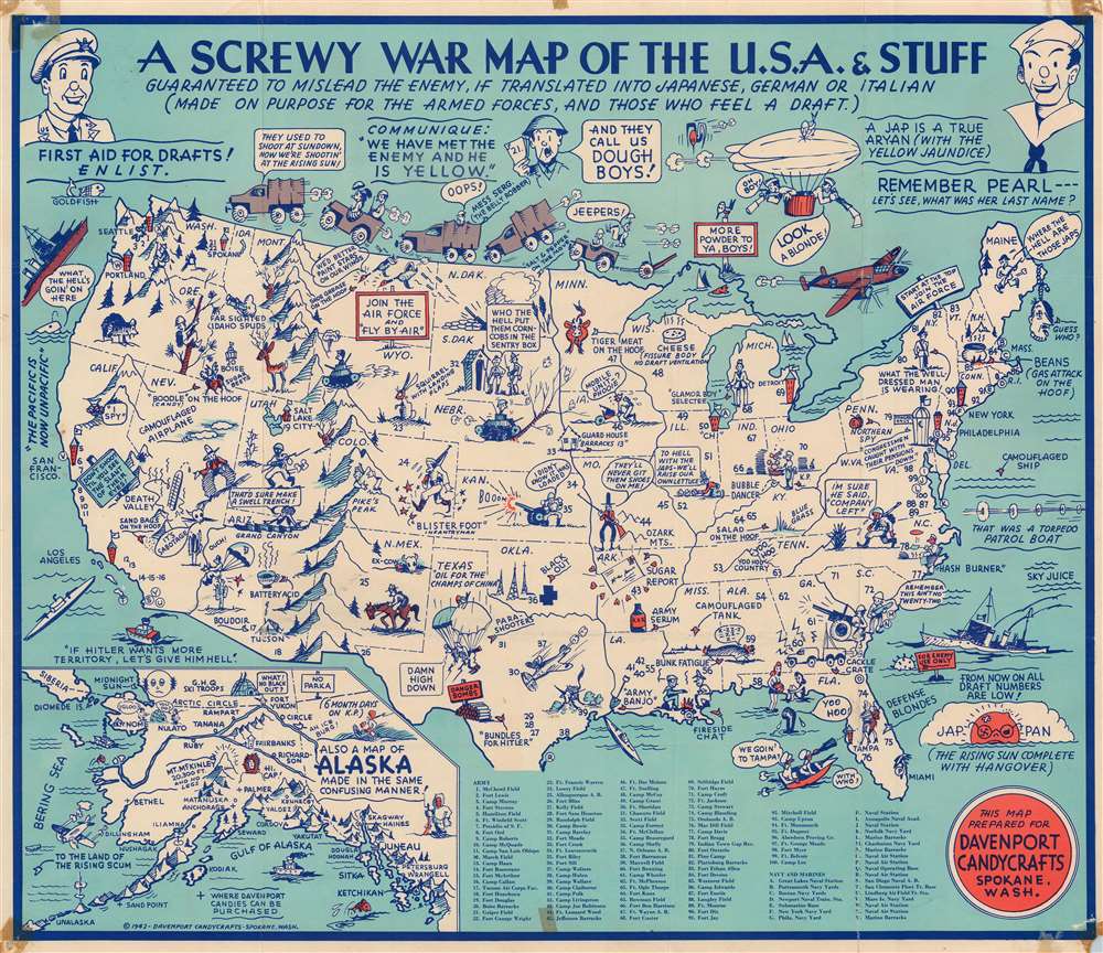
A Screwy War Map of the U.S.A. and Stuff. Guaranteed to Mislead the Enemy, If Translated Into Japanese, German or Italian (Made on Purpose for the Armed Forces, and Those Who Feel a Draft).
1942 (dated) 16.25 x 19 in (41.275 x 48.26 cm)
1942 (dated) 16.25 x 19 in (41.275 x 48.26 cm)
Description
This is a rare 1942 Davenport Candycrafts and (possibly) Jolly Lindgren comical pictorial map of the United States issued shortly after Pearl Harbor (December 7, 1941) and American involvement in World War II (1939 - 1945). The map marks a critical pivot in American attitudes towards the War - from 'We don't want to be involved' to 'let's get em!'
A Comical War Map?
The December 7, 1941 attack at Pearl is referenced at top right, where a sailor declares 'Remember Pearl --- Let's see, What was her name?' This tone carries throughout the whole map, which takes a jocular tone towards deadly serious global events. Other comical asides include a rabbit in Wyoming described as a 'squirrel with landing flaps', two geese in Montana that state 'We'd better paint stars on our wings', and a soldier in Arizona that yells into the Grand Canyon, 'That'd sure make a swell trench!' Other hilarious illustrations appear throughout the country, including a tank driving over a tree in Nebraska, a tank on top of the Rocky Mountains, and a convoy bouncing along the U.S.-Canada border. A periscope (perhaps from a German U-boat) appears off the coast of Florida and hails two beach-going women with a 'Yoo-Hoo!' A 'camouflaged airplane' (an illustration of a cloud) appears in Nevada, while a 'camouflaged ship' (open sea) is illustrated off the coast of Delaware.Anti-German/Japanese Propaganda
Along the 'squirrel with landing flaps' and other similar illustrations one finds derogatory comments directed toward the Japanese and Germans. A sign in California reads 'Don't Shoot 'Til You See the Slant of Their Eyes!' A person carrying a rifle with a bayonet in Maine screams 'Where the hell are those Japs?' He is not far from Adolph Hitler's severed head.Practical Elements
While most of the map is populated by comic vignettes, 100 U.S. Army bases are numerically labeled and correspond with an index along the bottom border. Twenty-five letters (A through Y) identify Navy and Marine bases as well.A Lost Lindgren Map?
Although unsigned, this cartographer's style bears a close resemblance to the work of Jolly Lindgren, the creator of the beloved 'Hysterical Map' series focusing on America's National Parks. Based on proximity and a stylistic similarity, many speculate that Lindgren, who was from Washington, was the creative force behind the several maps of Davenport Candycrafts.20th Century Pictorial Cartography
Pictorial qualities have been common in cartography from at least from the 16th century, when publishers like Braun and Hogenberg incorporated view-like qualities and other pictorial elements into their famous city plans. Braun and Hogenberg, and similar cartographers, issued their town books to express, not necessarily the geography of their subjects, but rather the 'essence' of the town/city. As mathematics and surveying principles became more advanced, travel increased, and the ability to translate 2 dimensional cartographic perspectives into an understanding of the actual world became commonplace, maps themselves transformed. This trend is a recognizable progression that evolved cartographic conventions from the 17th to the 19th centuries. By the late 19th century most maps had become geographical tools that illustrated the region cartographically but failed in the original raison d'être as expressed by Braun and Hogenberg, to illustrate a place's 'essence'. So, where a city map of 19th century Paris might provide a completely navigable presentation of the city, one could glean almost nothing of Paris' character from it. In the late 18th century, the first modern 'pictorial' style maps developed. These maps, like Tomas Lopez's 1788 map of Seville, attempted to provide both cartographic accuracy and pictorial elements that might convey the character of the city. In that case, Lopez incorporated pictorial vignettes to illustrate important buildings and monuments. This style became increasingly common throughout the 19th century and early 20th centuries, particularly for centers of commerce like London, Paris, and Rome, where they are often mass produced and referred to as 'monumental' maps. The style further evolved in the early to mid-20th century, when revolutionary cartographers and illustrators like MacDonald Gill, Jo Mora, Frank Dorn, Ernest Dudley Chase, and many others, combined vignette style illustrations, modern printing techniques, inspiration from Japanese printmaking and manga, and from clever satirical cartographers/artists like Fred Rose, to produce maps that once again focused on revealing the essence a place, usually, but not always, at the sacrifice of cartographic precision.Publication History and Census
This map was created for and published by Davenport Candycrafts of Spokane, Washington. Likely drawn by Jolly Lindgren. This is the only known cataloged surviving example of this map.Cartographer
Davenport Candycrafts, Inc. (fl. c. 1936 - c. 1959) was a Spokane, Washington-based candy maker and confectioner. Davenport Candycrafts copyrighted three 'hysterical maps' between 1936 and 1942, all of which are extremely rare. The maps are very much in the style of the Lindgren Brothers, also of Spokane. It is unclear if they were issued with Lindgren, or against Lindgren. It is telling that the last map in the series, 1942, replaces 'Hysterical' with 'Screwy'. These maps are Hysterical Map of America's Scenic Playground in Washington and Oregon (May 16, 1936), Hysterical Map of Alaska. For Chocolates and Confections (May 31, 1940), and the Screwy War Map of the USA and stuff. For Chocolates and Confections. (March 4, 1942). Davenport Candycrafts moved to Spokane in 1936 and leased the Pine Creek Creamery Building and the company bought the entire building the following year. We have been unable to trace any more of the company's history. More by this mapmaker...
Condition
Good. Wear along original fold lines. Light soiling. Verso repair to a fold separation. Closed margin tears professionally repaired on verso. Old cellophane tape evident in all four corner on recto (front).