
This item below is out of stock, but another example (left) is available. To view the available item, click "Details."
Details
1944 Baker WWII Pictorial Route Map of the Second Armored Division in Europe
$2,000.00
1944 Baker WWII Pictorial Route Map of the Second Armored Division in Europe
SecondArmoredFirstEdition-baker-1944$600.00

Title
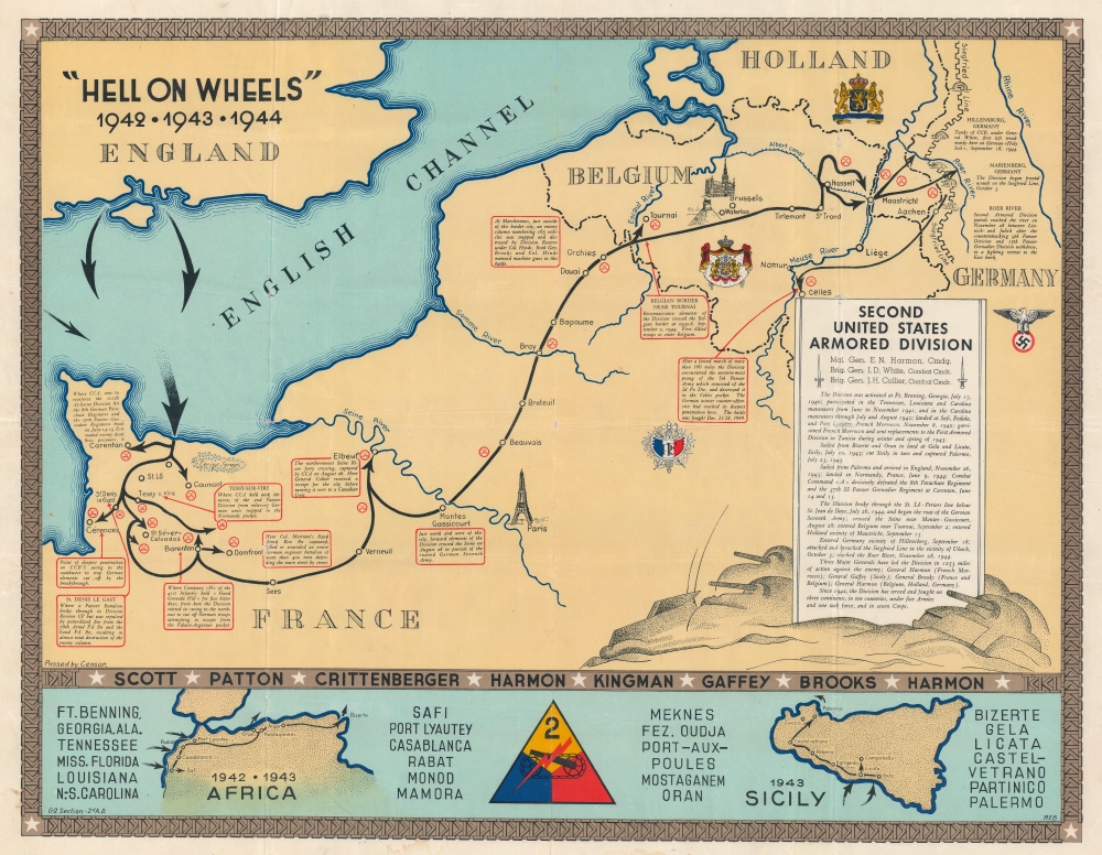
'Hell on Wheels' 1942 - 1943 - 1944. Second United States Armored Division.
1944 (undated) 21.25 x 27.5 in (53.975 x 69.85 cm)
1944 (undated) 21.25 x 27.5 in (53.975 x 69.85 cm)
Description
A rarity in an underappreciated genre, this is the 1944/45 Marion E. Baker World War II Second Armored Division Pictorial Route Map of Europe. Two elements stand out from most World War II (1939 - 1945) route maps. One is the scope of the Second Armored Division campaigning, stretching to including North Africa, Sicily, and western Europe. The second is that, unlike most route maps, the present map was published during the war, making it a part of the war experience, instead of a post-war summary.
A Closer Look
The map follows the Second Armored Division's movements during the Operation Torch landings in North Africa in November 1942 in the lower left. It names major cities and illustrates the division departing from Bizerte and Oran for Sicily. Then, in the lower right, a small map of Sicily highlights thier role in the July 1943 Operation Husky (the Allied invasion of Sicily). U.S. states and cities in Morocco, Algeria, Tunisia, and Sicily appear on either side of these maps, with a 2nd Armored insignia prominently displayed in the middle. The names of the division's commanders separate this section of the map from the large central map of western Europe.The Advance Across Europe
The central map focuses on the division's engagements from their arrival in France through their forced march to Celles, Belgium, during the Battle of the Bulge where they stopped the advance of the 2nd Panzer Division. Textboxes outlined in red provide short summaries of movements and actions, beginning with the German movements outside Carentan, France. Actions near St. Denis le Gast, Cérences, Domfort, Mantes Gassicourt (where the division crossed the Seine River), Tournai, and Marienberg follow. Crossed cavalry swords mark battles, many of which are not annotated. The coats-of-arms of the French Third Republic, Belgium, and the Netherlands mark these three countries, while the insignia of the Nazi Party appears in Germany. A narrative of the division's movements from activation in Georgia to the fighting along the Roer River occupies a cartouche on the right decorated by tanks.World War II Allied Route Maps
Maps tracing unit movements during World War II were created by both American and British forces during and after the war. As a genre, these maps represent a broad range of aesthetics, from the purely functional that label places and provide dates, to the artistic, even comic. Many combine the three and provide a visually striking but historically informative summary of the unit's peregrinations. The brutal reality of the war, however, was never very far away in any of these works.Publication History and Census
This map was drawn by Marion E. Baker, compiled by the Second Armored Division's Intelligence Section, and published in late 1944 or early 1945. We note a single cataloged example, which is part of the collection at the Pritzker Military Museum and Library in Chicago. A second larger and updated map was published by the Second Armored Division after the war.Cartographer
Marion Englebert Baker (February 18, 1922 - October 17, 2000) was an American draftsman and was born in High Springs, Florida. When he registered for the Draft during World War II he was working as a draftsman in the U.S. Engineer's Office in Jacksonville, Florida. He was drafted into the U.S. Army on November 1, 1942, and became a member of the Second Armored Division and worked in the Intelligence section. He eventually rose to the rank of Technician Fourth Grade. More by this mapmaker...
Condition
Average. Significant wear to original fold lines. Verso repairs at fold intersections. Closed margin tears professionally repaired on verso. Light dampstaining to bottom margin. Priced accordingly.
References
OCLC 817970163.