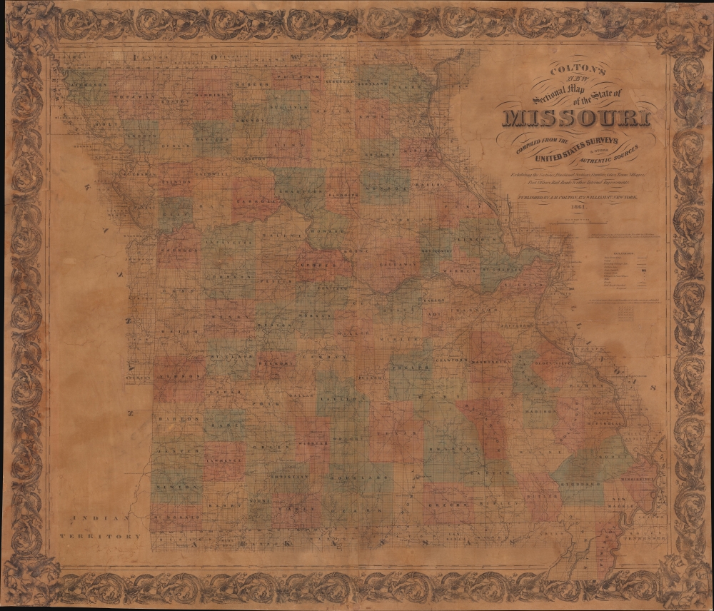
1861 Colton Map of Missouri at the outset of the Civil War
SectionalMissouri-colton-1861$1,200.00


Title
Colton's New Sectional Map of the State of Missouri. Compiled from United States Surveys and other Authentic Sources.
1861 (dated) 36.5 x 42.5 in (92.71 x 107.95 cm) 1 : 633600
1861 (dated) 36.5 x 42.5 in (92.71 x 107.95 cm) 1 : 633600
Description
This is an 1861 J. H. Colton map of Missouri at the beginning of the American Civil War (1861 - 1865). The map captures Missouri during a period when it was a violent microcosm of the greater abolition/pro-slavery divide. Although officially a slave state, Missouri harbored a large population of absolutists on both sides of the debate - and more from each side flooded in from 1850 on - turning it into a hotbed of violence and unrest that did not relent until long after the Civil War.
Tensions in Missouri began in 1820 following the Missouri Compromise when Missouri was allowed to join the Union as a slave state and Maine as a free state. As part of the compromise, Congress declared that slavery would be illegal north of 36° 30' latitude. This brought southern slaveholders to Missouri, but its proximity to free states made Missouri an important part of the Underground Railroad.
A little over thirty years later, as part of the Kansas-Nebraska Act, Congress decreed that the issue of slavery would be decided by a vote in the Kansas and Nebraska territories. This led to a flood of pro-slavery Missourians (known as 'Border Ruffians') into Kansas as well as anti-slavery 'Free-Staters' from northern states. Inevitably, violence erupted between these two factions in what has become known as 'Bleeding Kansas.' The two sides exchanged atrocities, with pro-slavery forces sacking Lawrence and abolitionist John Brown leading the Pottawatomie massacre.
Finally, during the 1860 - 1861 secession crises, Missouri declared that it would remain 'militarily neutral,' not declaring allegiance to either the Union or the Confederacy and fighting any incursion into the state from either side. However, Missouri's newly elected governor, Claiborne Fox Jackson, was an ardent supporter of the Confederacy and worked behind the scenes to advocate for Missouri's secession. A potential flashpoint in Missouri was the St. Louis Arsenal (the greatest Union asset in the state), which held over 39,000 small arms. Unionists believed Jackson wanted to use the Missouri State Guard to capture the Arsenal and send the arms south to the Confederacy. President Lincoln sent reinforcements to guard the Arsenal, which eventually led to Union forces attacking the Missouri State Guard after learning that the Guard had received Confederate artillery, presuming (rightly?) that the artillery would be used to attack the Arsenal.
Both sides attempted to sign a truce, but it did not last. By June 1861, the pro-Confederate elements of the government fled Jefferson City and created a government-in-exile in Neosho, Missouri, where it seceded. (In reality, this action meant almost nothing since the pro-Confederate government did not control any of Missouri.) After the governor's office was officially declared vacant, a pro-Union government took power, aligned with the Union, and tens of thousands of Missourians eventually served in the Union Army.
In Missouri, armed field and guerilla conflict persisted throughout the war. The guerrilla aspects of the war in Missouri lasted well into the 1880s, even if the continued violence was not seen as directly related to the war. The James-Younger Gang, led by Jesse James, was one of the groups that continued fighting long after the war.
A Closer Look
Missouri appears divided into counties, with the Public Land Survey System grid superimposed. Cities and towns are labeled, with St. Joseph, St. Louis, Kansas City, and Palmyra prominent. Roads and railroads (including the Hannibal and St. Joseph Railroad, the North Missouri Railroad, and the Cairo and Fulton Railroad) snake through the state.The American Civil War in Missouri
The American Civil War officially began on April 12, 1861, when Confederate forces fired on Fort Sumter in Charleston, South Carolina. However, the history of conflict in Missouri began decades earlier.Tensions in Missouri began in 1820 following the Missouri Compromise when Missouri was allowed to join the Union as a slave state and Maine as a free state. As part of the compromise, Congress declared that slavery would be illegal north of 36° 30' latitude. This brought southern slaveholders to Missouri, but its proximity to free states made Missouri an important part of the Underground Railroad.
A little over thirty years later, as part of the Kansas-Nebraska Act, Congress decreed that the issue of slavery would be decided by a vote in the Kansas and Nebraska territories. This led to a flood of pro-slavery Missourians (known as 'Border Ruffians') into Kansas as well as anti-slavery 'Free-Staters' from northern states. Inevitably, violence erupted between these two factions in what has become known as 'Bleeding Kansas.' The two sides exchanged atrocities, with pro-slavery forces sacking Lawrence and abolitionist John Brown leading the Pottawatomie massacre.
Finally, during the 1860 - 1861 secession crises, Missouri declared that it would remain 'militarily neutral,' not declaring allegiance to either the Union or the Confederacy and fighting any incursion into the state from either side. However, Missouri's newly elected governor, Claiborne Fox Jackson, was an ardent supporter of the Confederacy and worked behind the scenes to advocate for Missouri's secession. A potential flashpoint in Missouri was the St. Louis Arsenal (the greatest Union asset in the state), which held over 39,000 small arms. Unionists believed Jackson wanted to use the Missouri State Guard to capture the Arsenal and send the arms south to the Confederacy. President Lincoln sent reinforcements to guard the Arsenal, which eventually led to Union forces attacking the Missouri State Guard after learning that the Guard had received Confederate artillery, presuming (rightly?) that the artillery would be used to attack the Arsenal.
Both sides attempted to sign a truce, but it did not last. By June 1861, the pro-Confederate elements of the government fled Jefferson City and created a government-in-exile in Neosho, Missouri, where it seceded. (In reality, this action meant almost nothing since the pro-Confederate government did not control any of Missouri.) After the governor's office was officially declared vacant, a pro-Union government took power, aligned with the Union, and tens of thousands of Missourians eventually served in the Union Army.
In Missouri, armed field and guerilla conflict persisted throughout the war. The guerrilla aspects of the war in Missouri lasted well into the 1880s, even if the continued violence was not seen as directly related to the war. The James-Younger Gang, led by Jesse James, was one of the groups that continued fighting long after the war.
Publication History and Census
This map was created and published by J. H. Colton in 1861. The present 1862 edition is well represented in institutional collections. Colton first published his Sectional Map of Missouri in 1860 and his sons G. W. and C. B. Colton published editions of this map through the late 1870s.Cartographer
Joseph Hutchins Colton (July 5, 1800 - July 29, 1893), often publishing as J. H. Colton, was an important American map and atlas publisher active from 1833 to 1897. Colton's firm arose from humble beginnings when he moved to New York in 1831 and befriended the established engraver, Samuel Stiles. He worked under Stiles as the 'Co.' in Stiles and Co. from 1833 to 1836. Colton quickly recognized an emerging market in railroad maps and immigrant guides. Not a cartographer or engraver himself, Colton's initial business practice mostly involved purchasing the copyrights of other cartographers, most notably David H. Burr, and reissuing them with updated engraving and border work. His first maps, produced in 1833, were based on earlier Burr maps and depicted New York State and New York City. Between 1833 and 1855, Colton proceeded to publish a large corpus of guidebooks and railroad maps, which proved popular. In the early 1850s, Colton brought his two sons, George Woolworth Colton (1827 - 1901) and Charles B. Colton (1832 - 1916), into the map business. G. W. Colton, trained as a cartographer and engraver, was particularly inspired by the idea of creating a large and detailed world atlas to compete with established European firms for the U.S. market. In 1855, G.W. Colton issued volume one of the impressive two-volume Colton's Atlas of the World. Volume two followed a year later. Possibly because of the expense of purchasing a two-volume atlas set, the sales of the Atlas of the World did not meet Colton's expectations, and so, in 1856, the firm also issued the atlas as a single volume. The maps contained in this superb work were all original engravings, and most bear an 1855 copyright. All of the maps were surrounded by an attractive spiral motif border that would become a hallmark of Colton's atlas maps well into the 1880s. In 1857, the slightly smaller Colton's General Atlas replaced the Atlas of the World. Most early editions of the General Atlas published from 1857 to 1859 do not have the trademark Colton spiral border, which was removed to allow the maps to fit into a smaller format volume. Their customers must have missed the border because it was reinstated in 1860 and remained in all subsequent publications of the atlas. There were also darker times ahead; in 1858, Colton was commissioned at a sum of 25,000 USD by the government of Bolivia to produce and deliver 10,000 copies of a large format map of that country. Although Colton completed the contract in good faith, delivering the maps at his own expense, he was never paid by Bolivia, which was at the time in the midst of a series of national revolutions. Colton would spend the remainder of his days fighting with the Bolivian and Peruvian governments over this payment, and in the end, after a congressional intervention, he received as much as 100,000 USD in compensation. Nonetheless, at the time, it was a disastrous blow. J. H. Colton and Company is listed as one of New York's failed companies in the postal record of 1859. This led Colton into the arms of Alvin Jewett Johnson and Ross C. Browning. The 1859 edition of Colton's General Atlas lists Johnson and Browning as the 'Successor's to J. H. Colton' suggesting an outright buyout, but given that both companies continued to publish separately, the reality is likely more complex. Whatever the case may have been, this arrangement gave Johnson and Browning access to many of Colton's map plates and gave birth to Johnson's New Illustrated (Steel Plate) Family Atlas. The Johnson's Atlas was published parallel to Colton's atlases well into the 1880s. The Colton firm itself subsequently published several other atlases including an Atlas of America, the Illustrated Cabinet Atlas, the Octavo Atlas of the Union, and Colton's Quarto Atlas of the World. They also published a large corpus of wall maps, pocket maps, and guides. The last known publications of the Colton firm date to 1897 and include a map and a view, both issued in association with the Merchant's Association of New York. Alice M. Colton married August R. Ohman (May 3, 1859 - April 22, 1934) on January 5, 1897. In 1898, Ohman joined the Colton firm, which continued to publish as Colton, Ohman & Co. until 1901. More by this mapmaker...
Condition
Average. Mounted on fresh linen. Varnished. Dampstaining. Cracking. Wear along original fold lines. Some small areas reinstated or infilled.
References
OCLC 243700613, 33252811.