This item has been sold, but you can get on the Waitlist to be notified if another example becomes available, or purchase a digital scan.
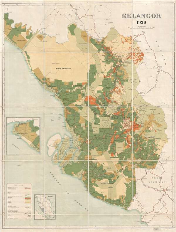
1929 F.M.S. Wall Map of Selangor (Kuala Lumpur)
Selangor-fms-1929$1,100.00

Title
Selangor 1929.
1929 (dated) 52 x 39 in (132.08 x 99.06 cm) 1 : 126730
1929 (dated) 52 x 39 in (132.08 x 99.06 cm) 1 : 126730
Description
An exceptional 1929 wall map of the Malay state of Selangor, including Malaysia's vibrant capital Kuala Lumpur. This map was issued by the Federated Malay States (F. M S.) Survey and printed in London by Edward Stanford. Being of enormous size, this map describes the state in incredible detail. The focus of the map appears to be land development. Forest Reserves, Games Reserves, and commercial estates are identified throughout. It also reveals development along railroads, major roadways, and important navigable rivers.
Today Selangor is a state on the west coast of Peninsular Malaysia, encircling the sprawling capital city of Kuala Lumpur. Selangor is the most developed and densely populated Malaysian state. In addition to its economic prosperity, Selangor is known for the Batu Caves, shown here just north of Kuala Lumpur, one of the most popular Hindu pilgrimage sites outside of India.
This map rarely appears on the market. The OCLC identifies only 3 institutional holdings.
CartographerS
Federated Malay States Survey (1922 - 1945), better known as the F.M.S. Survey Department, was established in the early 20th century to produce detailed surveys of British Malaya and the Straits Settlements. The survey department had offices in most major Malayan ports, including Singapore, Kuala Lumpur, Penang (Georgetown), and Malacca. They were the first official survey organization to publish detailed scientifically produced maps of the region. More by this mapmaker...
Server Error
404
Page Not Found
This page either doesn't exist, or it moved somewhere else.
That's what you can do
Condition
Very good. Folds into original linen binder.
References
OCLC 298352693.