This item has been sold, but you can get on the Waitlist to be notified if another example becomes available, or purchase a digital scan.
1927 Jo Mora Map of Monterey Peninsula - Seventeen Mile Drive!
SeventeenMileDrive-jomora-1927-2$625.00

Title
The Seventeen Mile Drive.
1927 (dated) 32 x 23.25 in (81.28 x 59.055 cm) 1 : 14500
1927 (dated) 32 x 23.25 in (81.28 x 59.055 cm) 1 : 14500
Description
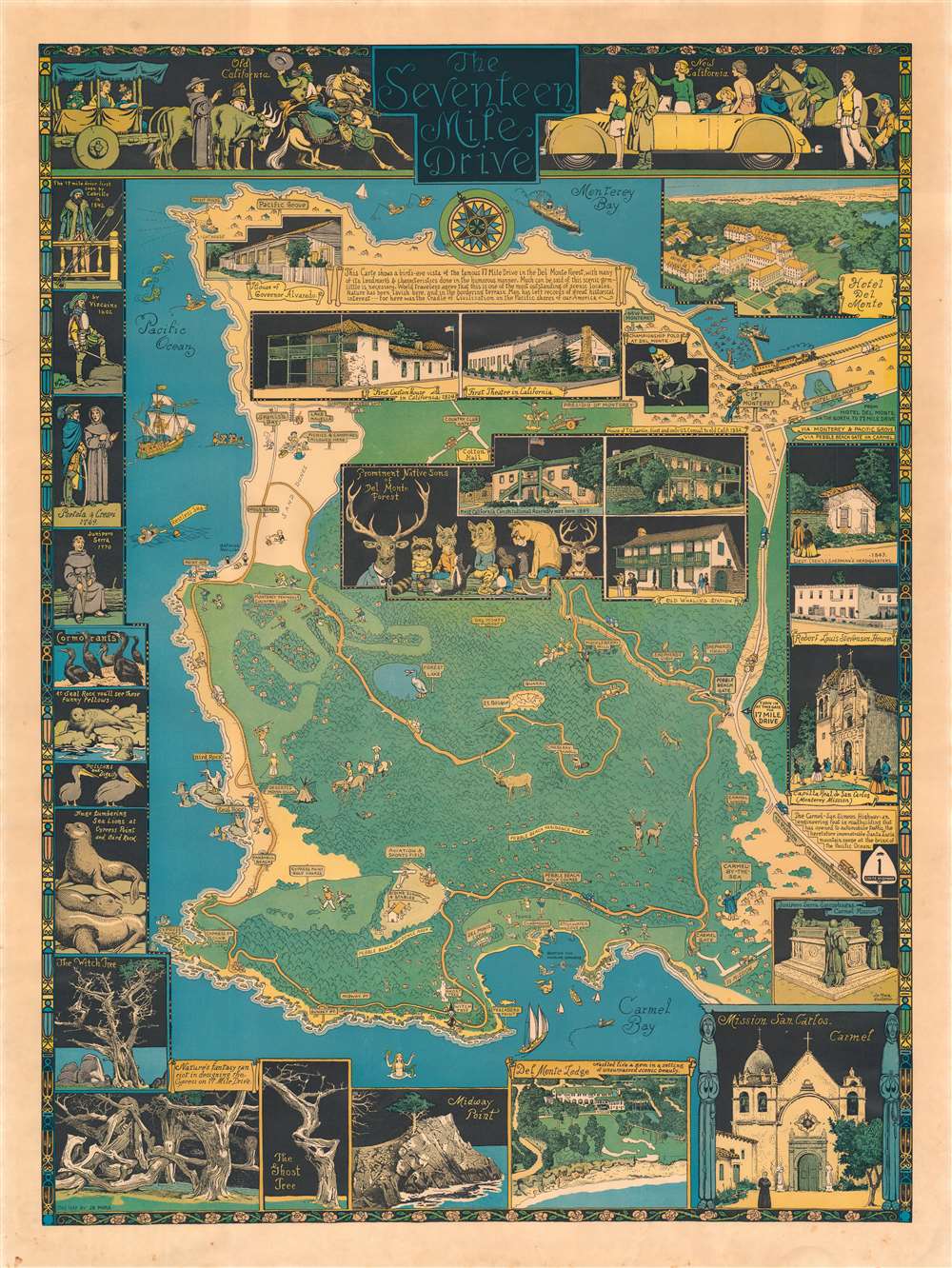
The rare first edition of Jo Mora's 1927 pictorial map of Monterey Peninsula's Seventeen Mile Drive. This is the second of Mora's iconic pictorial maps, which he called his 'cartes.' The map covers Monterey Peninsula in full, detailing the seventeen-mile drive around the peninsula and the various points of interest along the way.
Mora's First Maps
Both this and his first map were commissioned by his friend Samuel Finley Brown Morse, of the Hotel Del Monte. The Hotel Del Monte and the Del Monte Lodge were among the most luxurious resorts in the world - frequented by golden age Hollywood stars and other international celebrities. The main hotel burnt to the ground in 1924 and, after several years of reconstruction, reopened in April of 1926. This map, and Mora's California's Playground (1926), were commissioned by Del Monte Properties to promote the grand reopening. Both the Hotel Del Monte and the Del Monte Lodge are highlighted by large inset views at the top right, and bottom center. The map contains several additional insets illustrating historical buildings. Among them in a group portrait of some very well-dressed wildlife identified as the 'Prominent Native Sons of Del Monte Forest.'20th Century Pictorial Cartography
Pictorial qualities have been common in cartography from at least from the 16th century, when publishers like Braun and Hogenberg incorporated view-like qualities and other pictorial elements into their famous city plans. Braun and Hogenberg, and similar cartographers, issued their town books to express, not necessarily the geography their subjects, but rather the 'essence' of the town/city. As mathematics and surveying principles became more advanced, travel increased, and the ability to translate 2 dimensional cartographic perspectives into an understanding of the actual world became commonplace, maps themselves transformed. This trend is a recognizable progression that evolved from the 17th to the 19th centuries. By the late 19th century most maps had become geographical tools that illustrated the region cartographically, but failed in the original raison d'être as expressed by Braun and Hogenberg, to illustrate a place's 'essence'. So, where a city map of 19th century Paris might provide a completely navigable presentation of the city, one could glean almost nothing of Paris' character from it. In the late 18th century, the first modern 'pictorial' style maps developed. These maps, like Tomas Lopez's 1788 map of Seville, attempted to provide both cartographic accuracy and pictorial elements that might convey the character of the city. In that case, Lopez incorporated pictorial vignettes to illustrate important buildings and monuments. This style became increasingly commonly throughout the 19th century and early 20th centuries, particularly for centers of commerce like London, Paris, and Rome, where they are often mass produced and referred to as 'monumental' maps. The style further evolved in the early to mid-20th century, when revolutionary cartographers and illustrators like MacDonald Gill, Jo Mora, Frank Dorn, Ernest Dudley Chase, and many others, combined vignette style illustrations, modern printing techniques, inspiration from Japanese printmaking and manga, and from clever satirical cartographers/artists like Fred Rose, to produce maps that once again focused on revealing the essence a place, usually, but not always, at the sacrifice of cartographic precision.Publication History and Census
This map was issued in two editions, of which this is the first, identifiable by the inscription 'This Map by Jo Mora' in the lower left corner. A second edition was issued in 1928-1929 and is identifiable by the addition of a 'Del Monte Properties Co.' copyright in the lower right corner.Cartographer
Joseph 'Jo' Jancito Mora (October 22, 1876 – October 10, 1947) was an Uruguayan born artist active in California during the first half of the 20th century. Mora immigrated to California as a young man. He studied art in Boston and, after graduating, worked there briefly before relocating to California. In cartographic circles Mora is known for pioneering the 20th century pictorial map. In a series he referred to as his 'cartes,' published between in 1926 and 1942, Mora developed a pictorial style that combined cartography with colorful cartoonish image of local figures, folklore, history, and natural wonders. His earliest maps were commissioned by the Hotel Del Monte and included California's Playground and The Seventeen Mile Drive. As he matured as a cartographer, his work became increasingly dense, often packed with tiny figures, each expressive of some aspect of regional life. Mora, often called the 'Renaissance man of the West' also worked as an illustrator, muralist, sculptor, photographer, and writer. His masterpiece is considered to be the Father Serra Cenotaph, a bronze and marble sculpture at the Memorial Chapel in El Carmelo Mission, Carmel, California. His map work included Monterey Penninsula (1927), and Seventeen Mile Drive (1927), California (1927), Grand Canyon (1931), Yosemite (1931), Yellowstone (1936), Carmel-By-The-Sea (1942), California (1945) (large and small versions), Map of Los Angeles (1942), among others. More by this mapmaker...
Condition
Very good. Warm even toning. Very minor edge wear.
References
Rumsey 8559.000. OCLC 953572709. Hornsby, S. J., Picturing America: The Golden Age of Pictorial Maps, page 30.