1932 Jichisan Shōkai Bi-Lingual Large-Format Map of Shanghai, China
Shaghai-jichisanshokai-1932$2,500.00


Title
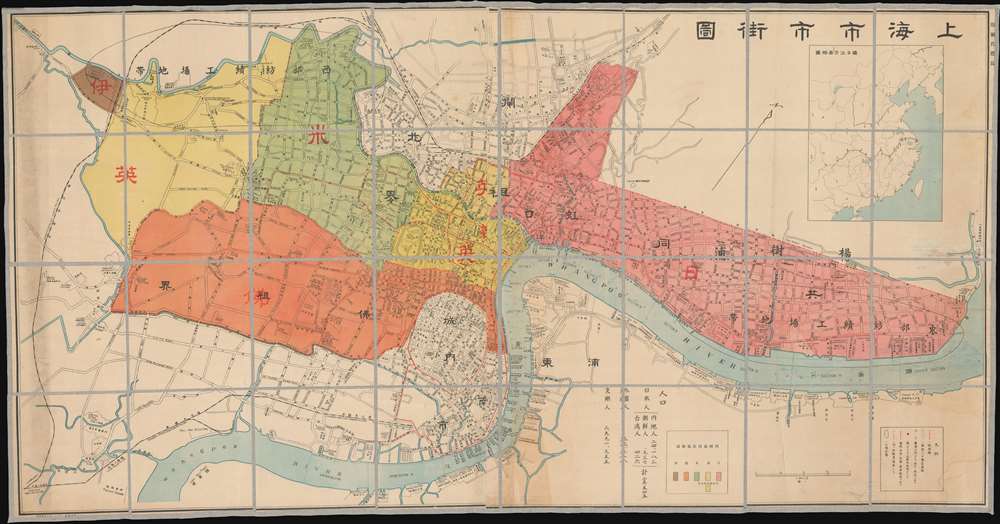
Shanghai City Street Map. / 上海市市街圖
1932 (undated) 32 x 61.5 in (81.28 x 156.21 cm) 1 : 11176
1932 (undated) 32 x 61.5 in (81.28 x 156.21 cm) 1 : 11176
Description
An impressively proportioned bi-lingual map of Shanghai, China, issued by Jichisan Shōkai (ジーチーサン商會) in 1932, during the January 28 Incident (Shanghai War) - a precursor to the Second Sino-Japanese War (1937 - 1945).
A Closer Look
Centered on the Bund, the map covers the Shanghai International Settlement, French Concession, various British Concessions, and the informal Japantown or Japanese Concession. Printed with both English and Chinese text, the map illustrates areas of control, as well as various businesses, roads, and services. It is contemporaneous with the Shanghai Incident of 1932, also known as the January 28 Incident or the Shanghai War (see below). While the Japanese had no official concession in Shanghai, by 1932 Japanese colonists had largely taken over the former American Settlement north of the Huangpu River. Also, according to the Treaty of Shimonoseki, the Japanese had rights to own businesses in China - something they took full advantage of in Shanghai, as evidenced here. At the bottom, there are population notes (Chinese, 2,991,955, Foreigners 33,218, Japanese 25,545), intended to argue for Japanese power and legitimize Japanese claims in the city.Color Coding of Territory
The map employs color coding to define the extra-territorial concessions and zones of administration, particularly the Shanghai International Settlement. The Settlement is divided between the former American Concession (red) largely taken over by the Japanese, the 1846-48 British Concession (yellow), the 1899 expanded International Concession (Green, assigned as American), additional 1901 expansions along the Extra-Settlement Road System (light yellow), and a final 1909 Extra-Settlement Road Expansions to Jessfield Road (Zhongshan) ultimately denied by the increasingly anti-foreign Chinese (brown). Some of these, although not officially part of the International Settlement, were administered and developed by the Settlement, such as the brown area at far left - in this zone specifically, we can see the Toyoda Cotton Spinning Company, precursor of the modern conglomerate Toyota. The French Concession, (orange) appears below the International Settlement and is at its ultimate expression.Shanghai Incident of 1932
The conflict of January 28th, 1932, also known as the Shanghai Incident or Shanghai War, was a precursor to the Second Sino-Japanese War, which would begin a few years later. Following several alleged attacks on Japanese nationals, the Japanese launched a Blitzkrieg-style attack on Chinese Nationalist forces with the supposed intent of protecting Japanese civilians residing in the Hongkou District, an informal Japanese Concession within the International Settlement. Chinese Nationalist troops concentrated in Zhabei in order to protect the strategically important Shanghai Railway Station, through which supplies and reinforcements could be readily delivered. The Chinese resistance proved stubborn, and both sides established perimeters along the Huangpu River. A similar perimeter was established in the south, along the Wusong River, to protect the British and French Concessions. The Japanese nonetheless pursued their attack, using gunboats on the Wusong River and Hunagpu River to harry the Chinese. Ultimately, the two sides fought to a near standstill. In late February, the League of Nations forced a ceasefire, the Shanghai Ceasefire Agreement, which turned Shanghai into a demilitarized zone.Shanghai International Settlement
The Shanghai International Settlement was created in 1863 when the British and American Shanghai enclaves merged. These concessions had been granted to England and the United States as part of the Unequal Treaties that followed the Opium Wars. From about 1854, the settlements were governed by the Shanghai Municipal Council, a British-dominated board of government officials and powerful merchants. The board issued restrictions limiting Chinese habitation on International Settlement territory and oversaw the construction of public services, including trams, a sewage system, highways, and port buildings. The International Settlement expanded several times in the late 19th and early 20th century. In addition, they constructed and administered Extra-Settlement Roads into the surrounding country, which further allowed for informal expansion. It became an enclave of peace and prosperity when the Japanese invaded Shanghai in 1937, but this abruptly came to an end with the Japanese bombing of Pearl Harbor and the subsequent 1941 invasion of the International Settlement. After the War, the International Settlement lands were returned to Chinese sovereignty.Shanghai French Concession - 上海法租界
On April 6, 1849, Lin Kouei (麟桂), the Chinese governor of Shanghai, granted French Consul Charles de Montigny (1805 - 1868) a proclamation ceding extraterritoriality to France in order to establish a trading colony. The Concession initially occupied a narrow collar of land around the northern end of the Chinese City, south of the British Settlement, an area of 66 hectares. It was subsequently expended several times. A further small strip of riverside land to the east of the Chinese City was added in 1861, to allow for the Quai de France, docks servicing shipping between China and France. Between 1899 and 1900, the French Concession further expanded, nearly doubling in size with new territory extending west of the original grant. It expanded again in 1914, reaching as far west as modern Huashan Lu (Avenue Haig). By the 1920s, the western part of the French Concession had become the most desirable residential area of Shanghai, popular both with foreign nationals and wealthy Chinese. The Concession was mistakenly bombed during the chaotic 1937 Battle of Shanghai, fought between the National Revolutionary Army (NRA) of the Republic of China (ROC) and the Imperial Japanese Army (IJA). In 1943, the French Concession was handed over to the Japanese puppet Wang Jingwei Regime by Vichy France. The turnover was officially ratified after the War by the Sino-French Accord of February 1946, signed by the French Ambassador and Chiang Kai-shek. Today, the French Concession, with its tree-lined boulevards and French colonial architecture, remains Shanghai's most desirable neighborhood.Publication History and Census
This map was published by the Japanese printer Jichisan Shōkai in Tokyo to capitalize on general interest in Shanghai following the January 28 Incident. This map is rare. Beyond our own holdings, we have identified only one other surviving example, in the National Diet Library of Japan.Cartographer
Jichisan Shōkai (ジーチーサン商會, 1927 - 1945), also known as the 'Graphic Times Sun,' was a Japanese printing, photography, and news concern active in the Kyobashi district of Tokyo during the pre-war period. The firm was founded by the photographer Yamahata Shogyoku (山端祥玉, 1887 - 1963) in May of 1927, Showa 1. Shogyoku had earlier been living in Singapore before returning to Tokyo in Showa 1, importing modern photo processing machinery, and establishing Jichisan Shōkai. Before the outbreak of World War II, Shogyoku was hired to take a series of groundbreaking photos of the Emperor and his family in an attempt to express their humanity - a revolutionary idea that ran counter to the traditional notion of the emperor's direct lineage from the sun-goddess Amaterasu. In 1945, at the end of the Pacific War, the firm changed its name to Yamahata Institute of Photography. In 1947, it was taken over by Shogyoku's son, Yosuke Yamahata (山端庸介, August 6, 1917 - April 18, 1966), who became famous for his heartbreaking photos of the aftermath of Hiroshima and Nagasaki which transformed our global understanding of war. More by this mapmaker...
Condition
Good. Some discoloration. Linen backing replaced. Comes with custom clamshell bookbox.
References
National Diet Library, YG913-2729. OCLC 676003163.