This item has been sold, but you can get on the Waitlist to be notified if another example becomes available, or purchase a digital scan.
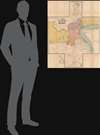
1920 Churin Multilingual Map of Shanghai, China
Shanghai-churin-1920$3,750.00

Title
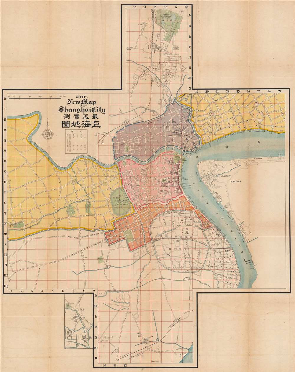
The New Map of Shanghai City / 最新實測上海地圖.
1920 (undated) 35 x 28 in (88.9 x 71.12 cm) 1 : 11500
1920 (undated) 35 x 28 in (88.9 x 71.12 cm) 1 : 11500
Description
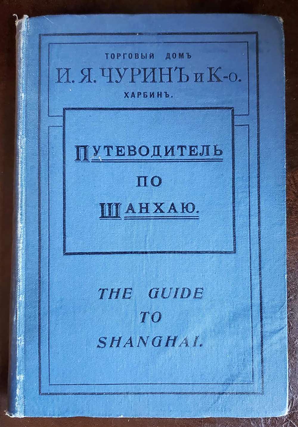
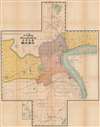
This is a rare and intriguing c. 1920 guide and map of Shanghai published by the Russian firm Churin and Co. (Чурин и Ко) to accompany their Russian-language Guide to Shanghai (Путеводитель по Шанхаю). The map is exceptional in several respects, most obviously in its cross-shaped layout. Moreover, although the travel guide is in Russian, the map itself is a combination of Japanese, Chinese, English, and French, reflecting both the cosmopolitan nature of treaty port and this map's ad hoc production process.
The most immediate distinctive feature is its offset cross shape, seemingly adopted to include the important rail infrastructure of Shanghai (Woosong Railway 淞滬鐵路 at north and the Shanghai-Hangzhou Railway 滬杭鐵路 to the south). Another oddity is the multi-color scheme adapted to denote Shanghai's foreign concessions. Although many maps of Shanghai from this era clearly differentiate between the International Settlement (British, American, and Japanese dominated) and the French Concession (here in orangish-red), and some mark out the Japanese neighborhood of the International Settlement (in purple here), it is less common to see the International Settlement split up into five sections, which here are divided by creeks and canals that once ran through the city, most of which were filled in around the time of this map's publication.
This map was most heavily influenced by a pre-existing Japanese map, as evidenced by the prominence of Japanese businesses and institutions, many of which remain untranslated (such as Toa Dobunshoin University 東亞同文書院 and Nippon Yusen 日本郵船會社), and 'Japanisms' such as the use of 獨乙領事館 for the German Consulate and 支那 for China, standard in Japanese but highly unusual if not taboo in Chinese, to indicate the China Post Office (abbreviated here as 'C.P.O.' in English). Moreover, the characters used in the map's title (最近實測…地圖) were much more common in Japanese than Chinese maps of the era.
Elsewhere, especially in the Chinese administered parts of the city outside the concessions, Chinese text remains untranslated, mostly referring to government and military facilities, railways, and utilities. There also seem to have been some transcription and translation issues, such as 'Bnitish Caol' for 'British Gaol,' 'Purlicschools' for 'Public Schools,' 'Friench Park' for 'French Park,' and 'Kally and Walsh' for 'Kelly and Walsh,' a prominent local publisher, including of maps.
Taking all of this into account, it is likely that Churin and Co. aimed to quickly produce a map for White Russian emigrees moving to Shanghai (see below) and used an amalgam of existing maps of Shanghai to include in this guidebook. The strongest influence looks to be from a Japanese map, with Chinese and English language maps also proving useful for various parts of the city. It is unlikely that French-language maps were consulted extensively, unfortunate for the users of this guidebook as most of the White Russians who migrated to Shanghai ended up residing in the French Concession.
As a strategically located entrepot near the mouth of the Yangtze River, Shanghai quickly became a gateway to the entire Yangtze Delta. The light administration of the foreign concessions led to the city's reputation for economic dynamism, multiculturalism, crime, drugs, prostitution, and urban poverty.
Multiple nationalities also formed a subaltern stratum of police officers, servants, small business owners, and entertainers, including Parsis and Sikhs (a Sikh Temple is noted in the top portion here), Annamese, Koreans, Russians, Portuguese (Macanese), and Filipinos. In the early 20th century, Japanese influence increased considerably, and the number of Japanese residents (including Koreans and Okinawans) eventually grew to over 100,000 during the Second World War.
After stopping in Harbin, many of these Russian emigrees were drawn to the warmer clime and economic opportunities of Shanghai. As many White Russians had been elites under the Tsar and fled with little of their wealth (most of which was tied up in land), their spartan life in Shanghai was a radical departure. They remained stateless and had trouble securing work unless they spoke English or French well, leading many young women into dance halls and prostitution, while men could hope to find work as policemen or gendarmes. While their situation improved somewhat with time and multiple institutions (schools, churches, charities) held the community together, the Russians of Shanghai remained impoverished, an incongruous site for foreigners visiting Shanghai expecting to see the Chinese living in penury. Many of Shanghai's Russians stayed until the Communist takeover in 1949, after which many fled to Hong Kong or further afield, though a handful remained in Shanghai through the Maoist period.
For the historical reasons mentioned above, it is likely that this map and guidebook were published after 1917, when the number of Russians traveling or moving to Shanghai increased dramatically. The appearance of the map is also consistent with maps of Shanghai from the 1920s. However, the borders of the French Concession here do not include a large extension of the concession's territories in 1914. Also in 1914, the International Settlement and French Concession agreed to fill in the Yangjingbang 洋涇浜, present here, a creek running east-west just south of the Public Recreation Ground (now People's Park). Therefore, it is likely that since this map cobbled together elements of existing maps, the maps used were out of date by the time of publication. The present map and book differ from a 1919 Russian-language guide with the same title, published in Shanghai by G.G. Sunnenberg (Г.Г. Сюненберг, OCLC 1031202893), which is also very scarce and was no doubt published with the same customer base in mind. The only other known example of this map is held by the Library of Congress, while the National Diet Library holds the only example of a map dated to 1918 that may be the Japanese 'base map' (OCLC 676002735) on which the present map is based.
A Closer Look
This map shows the treaty port of Shanghai, China's largest and most modern city in the early 20th century. It focuses on the foreign-administered concessions, along with the older walled Chinese city. To a lesser extent, the Chinese-administered parts of the city outside the old walled city that were home to much of the city's industry and population are also depicted. A small inset map shows Xujiahui (Siccawei 徐家匯), a neighborhood to the south and west of the main map that was dominated by a Jesuit mission.The most immediate distinctive feature is its offset cross shape, seemingly adopted to include the important rail infrastructure of Shanghai (Woosong Railway 淞滬鐵路 at north and the Shanghai-Hangzhou Railway 滬杭鐵路 to the south). Another oddity is the multi-color scheme adapted to denote Shanghai's foreign concessions. Although many maps of Shanghai from this era clearly differentiate between the International Settlement (British, American, and Japanese dominated) and the French Concession (here in orangish-red), and some mark out the Japanese neighborhood of the International Settlement (in purple here), it is less common to see the International Settlement split up into five sections, which here are divided by creeks and canals that once ran through the city, most of which were filled in around the time of this map's publication.
A Curious Compilation Process
The closer one examines this map, the stranger it becomes. While the map's title is in Japanese and English, much of the map itself is in Japanese and Chinese, and the grid along the border uses Cyrillic letters. Even within the legend, a note in Japanese explains the merging of the British and American Concessions to form the International Settlement (1863), while the terminology for symbols on the map uses Chinese to denote railways (铁路 tielu instead of 鐵道 tiedao or tetsudō in Japanese), even though the map itself uses Japanese (淞滬鐵道 instead of 淞滬铁路)! Partly this is a result of the cosmopolitan nature of Shanghai, as well as the still-evolving terminology for new technologies and the influence of Japanese on Chinese in this regard (鐵道 and 铁路 were often used interchangeably until the latter became the standard phrase in Chinese), but it also shows the multiple sources that the (Russian) makers drew on.This map was most heavily influenced by a pre-existing Japanese map, as evidenced by the prominence of Japanese businesses and institutions, many of which remain untranslated (such as Toa Dobunshoin University 東亞同文書院 and Nippon Yusen 日本郵船會社), and 'Japanisms' such as the use of 獨乙領事館 for the German Consulate and 支那 for China, standard in Japanese but highly unusual if not taboo in Chinese, to indicate the China Post Office (abbreviated here as 'C.P.O.' in English). Moreover, the characters used in the map's title (最近實測…地圖) were much more common in Japanese than Chinese maps of the era.
Elsewhere, especially in the Chinese administered parts of the city outside the concessions, Chinese text remains untranslated, mostly referring to government and military facilities, railways, and utilities. There also seem to have been some transcription and translation issues, such as 'Bnitish Caol' for 'British Gaol,' 'Purlicschools' for 'Public Schools,' 'Friench Park' for 'French Park,' and 'Kally and Walsh' for 'Kelly and Walsh,' a prominent local publisher, including of maps.
Taking all of this into account, it is likely that Churin and Co. aimed to quickly produce a map for White Russian emigrees moving to Shanghai (see below) and used an amalgam of existing maps of Shanghai to include in this guidebook. The strongest influence looks to be from a Japanese map, with Chinese and English language maps also proving useful for various parts of the city. It is unlikely that French-language maps were consulted extensively, unfortunate for the users of this guidebook as most of the White Russians who migrated to Shanghai ended up residing in the French Concession.
Treaty Port Shanghai
Although it was already a sizable port by 1842, Shanghai expanded at a tremendous pace when it was designated a treaty port after the First Opium War (1839 - 1842). British and French traders and missionaries were leased land outside of the walled 'Chinese City,' particularly along the Bund (riverfront). Due to the extraterritoriality clauses of the Treaty of Nanjing and subsequent 'unequal treaties,' over time the areas where Westerners resided effectively became exempt from Chinese jurisdiction. In 1862, the French split with the Americans and British, creating a distinct French Concession, causing the 'Anglos' to form the International Settlement (divided at Avenue Edward VII 愛多亞路, Yan'an Rd. today).As a strategically located entrepot near the mouth of the Yangtze River, Shanghai quickly became a gateway to the entire Yangtze Delta. The light administration of the foreign concessions led to the city's reputation for economic dynamism, multiculturalism, crime, drugs, prostitution, and urban poverty.
Shanghai Sojourners
The British influence was particularly strong in the International Settlement, but the city's elite was a cosmopolitan mix of Europeans, Americans, Japanese, Chinese, and others. Trading diasporas from across China and the globe set up shop there, including Baghdadi Jews, whose names (Kadoorie, Sassoon) were synonymous with Shanghai's high society. Since the exact sovereign status of the treaty ports was unclear, Shanghai became a refuge for stateless individuals and refugees, including White Russians and, later, Viennese Jews fleeing the Nazis.Multiple nationalities also formed a subaltern stratum of police officers, servants, small business owners, and entertainers, including Parsis and Sikhs (a Sikh Temple is noted in the top portion here), Annamese, Koreans, Russians, Portuguese (Macanese), and Filipinos. In the early 20th century, Japanese influence increased considerably, and the number of Japanese residents (including Koreans and Okinawans) eventually grew to over 100,000 during the Second World War.
Shanghai's Russian Community
Although Shanghai had a community of Russians predating the Russian Revolution (mostly traders), it became a refuge for White Russians fleeing Bolshevik rule in the late 1910s and early 1920s. As the city was under complex and loose jurisdiction resulting from its status as a treaty port, it was an ideal landing spot for stateless people. Since the completion of the Trans-Siberian Railway, Russia had strong economic and geopolitical interest in Manchuria, which coalesced around Harbin and the China Eastern Railway, to the point that more than 40,000 Russians lived in Harbin at the time of the Russian Revolution, a number that nearly tripled as opponents of the Bolsheviks sought to escape Russia in the following years.After stopping in Harbin, many of these Russian emigrees were drawn to the warmer clime and economic opportunities of Shanghai. As many White Russians had been elites under the Tsar and fled with little of their wealth (most of which was tied up in land), their spartan life in Shanghai was a radical departure. They remained stateless and had trouble securing work unless they spoke English or French well, leading many young women into dance halls and prostitution, while men could hope to find work as policemen or gendarmes. While their situation improved somewhat with time and multiple institutions (schools, churches, charities) held the community together, the Russians of Shanghai remained impoverished, an incongruous site for foreigners visiting Shanghai expecting to see the Chinese living in penury. Many of Shanghai's Russians stayed until the Communist takeover in 1949, after which many fled to Hong Kong or further afield, though a handful remained in Shanghai through the Maoist period.
Publication History and Census
This map was included in the book The Guide to Shanghai (Путеводитель по Шанхаю), published in Harbin by the I. Y. Churin and Co. Trading House (И. Я. Чурин и Ко торговый домъ). It is undated and a publication date is difficult to estimate. Individual buildings on the map are not necessarily definitive as placenames could be outdated due to differences between colloquial and official names. For instance, Nanyang University (南洋公學) in the inset map had been founded in 1890 but 'Nanyang' had not been included in its official name since 1905, even though it continued to be popularly known as Nanyang. Many of the buildings present here were built in the first decade of the 20th century or in the 1910s.For the historical reasons mentioned above, it is likely that this map and guidebook were published after 1917, when the number of Russians traveling or moving to Shanghai increased dramatically. The appearance of the map is also consistent with maps of Shanghai from the 1920s. However, the borders of the French Concession here do not include a large extension of the concession's territories in 1914. Also in 1914, the International Settlement and French Concession agreed to fill in the Yangjingbang 洋涇浜, present here, a creek running east-west just south of the Public Recreation Ground (now People's Park). Therefore, it is likely that since this map cobbled together elements of existing maps, the maps used were out of date by the time of publication. The present map and book differ from a 1919 Russian-language guide with the same title, published in Shanghai by G.G. Sunnenberg (Г.Г. Сюненберг, OCLC 1031202893), which is also very scarce and was no doubt published with the same customer base in mind. The only other known example of this map is held by the Library of Congress, while the National Diet Library holds the only example of a map dated to 1918 that may be the Japanese 'base map' (OCLC 676002735) on which the present map is based.
Cartographer
Ivan Yakovlevich Churin (Иван Яковлевич Чурин, 伊万·雅阔列维奇·秋林; October 4, 1833 - April 29, 1895) was a wealthy Russian merchant, businessman, and philanthropist based in Irkutsk. As a young man, he joined an expedition led by Nikolay Muravyov-Amursky (Никола́й Никола́евич Муравьёв-Аму́рский, 1809 - 1881), which led to a lifelong connection with Siberia and the Russian Far East. He began trading in the region, gaining knowledge of its geography and cultures, and then moved on to real estate, gold mines, and a number of other industries. Much of Churin's business was in China, where Churin and Co. (秋林公司 Qiulin gongsi) owned buildings, warehouses, wharves, and department stores in many different cities. They also had interests in tobacco, spirits, perfumes, paint, clothing, and many other products. Churin was also an investor and backer of the China Eastern Railway. Churin's food production branch is credited with inventing Hongchang (红肠) a smoked sausage similar to polish kielbasa and Lithuanian Skilandis (they are alternatively known as Lidaosi 里道斯, a transliteration of the Russian phrase for Lithuanian sausage). Their sausages became and remain very popular in Chinese northeastern cuisine and are especially associated with Harbin. After the Russian Revolution, the company relocated to Harbin and operate, coming under control of the Hong Kong and Shanghai Bank (HSBC) and then Japanese managers. When the Soviets occupied Manchuria in 1945, it became a state-owned company but was handed over to Chinese state ownership in 1953. It continues to operate to this day, with the department stores and food industry portion of the Churin Group (秋林集团 Qiulin jituan), the latter spun off and privatized (秋林里道斯 Qiulin Lidaosi) in 2007, being the company's most recognizable legacy in China. More by this mapmaker...
Source
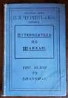
Путеводитель по Шанхаю, (Shanghai: Churin) c. 1920.
Condition
Very good. Fold lines visible. Some offsetting and toning in white spaces.
References
OCLC 761165044.