This item has been sold, but you can get on the Waitlist to be notified if another example becomes available, or purchase a digital scan.
1946 Kelly and Walsh Map of Shanghai, China
Shanghai-kellywalsh-1946$350.00

Title
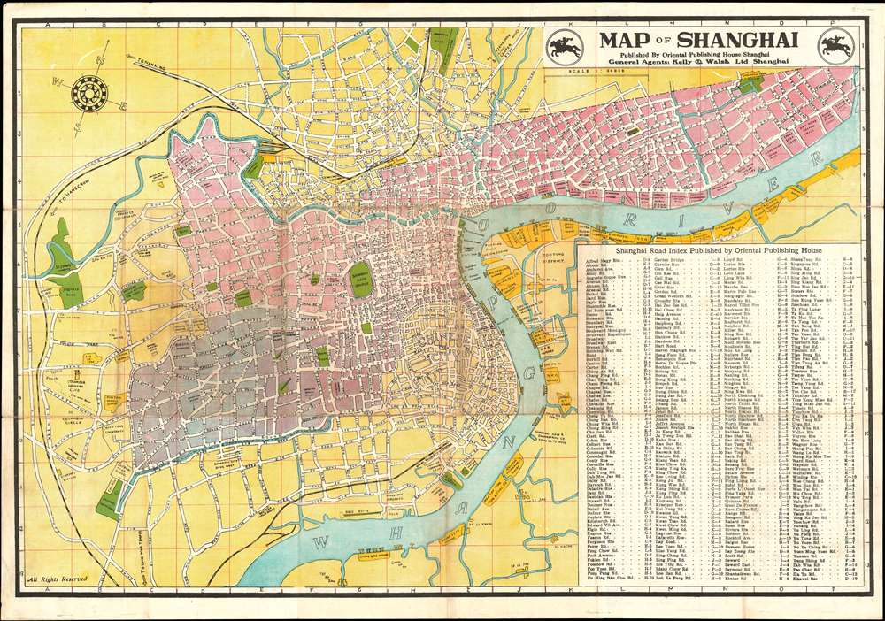
Map of Shanghai.
1946 (dated) 21.5 x 30.5 in (54.61 x 77.47 cm) 1 : 20000
1946 (dated) 21.5 x 30.5 in (54.61 x 77.47 cm) 1 : 20000
Description
An uncommon 1946 English language map of Shanghai, China issued by the Oriental Publishing House for the firm of Kelly and Walsh. The map centers on the old Chinese city, with its former circular walls apparent. The former International Settlement is colored pink, while the French Concession is purple. Along the Bund, various privae clubs, hotels, banks, and other business are noted. ‘Pootung’ (Pudong), across the Huangpu River, is largely undeveloped but warehouses lining shore. All streets are labelled, and an extensive street index occupies the lower right quadrant. The verso features a handy table reconciling old European street names and the ‘new’ Chinese names adopted following the collapse of the concession system.
China itself was in the midst of a Civil War between the Kuomintang (KMT) government of the Republic of China and the Communist revolutionaries. With the end of extraterritoriality in Shanghai, the destruction of the Japanese Occupation, and the destabilizing effects of the Kuomintang-Communist Civil War, foreign residents and businesses fled Shanghai for safer harbors in Hong Kong and elsewhere. When the Chinese Communist Party finally took control of Shanghai in 1949, just four years after this map was issued, foreign influence and investment was systematically terminated.
The OCLC identifies three examples in institutional collections, at Cornell, U.C. Berkeley, and the National Library of Australia. We are aware of at least 2 in private collections.
The End of Extraterritoriality in Shanghai
The map illustrates an ephemeral and often ignored period in the history of Shanghai, and China in general, between the end of World War II (1939 - 1945) and the Communist Revolution of 1949. Shanghai was still reeling from years of brutal Japanese occupation - which ended just one year before this map was published. During the War, the British, American and French concessions suffered under the Japanese occupation and were ultimately ended. The British and American concessions were terminated in 1943, when the International Settlement (pink) was retroceded to China. The French (purple) retained their concession until 1946, one year after the war, when it too was retroceded back to China. The table on the back of the map, which reconciles old European and new Chinese place names, is emblematic of the transition Shanghai was then undergoing.China itself was in the midst of a Civil War between the Kuomintang (KMT) government of the Republic of China and the Communist revolutionaries. With the end of extraterritoriality in Shanghai, the destruction of the Japanese Occupation, and the destabilizing effects of the Kuomintang-Communist Civil War, foreign residents and businesses fled Shanghai for safer harbors in Hong Kong and elsewhere. When the Chinese Communist Party finally took control of Shanghai in 1949, just four years after this map was issued, foreign influence and investment was systematically terminated.
Publication History and Census
This map was printed in Shanghai in 1946 by the Oriental Publishing House, agents of the publishing firm Kelly and Walsh. This map is scarce. The OCLC identifies three examples in institutional collections, at Cornell, U.C. Berkeley, and the National Library of Australia. Most (but not all) examples are dated on the cover, which is attached to the verso, but where the cover is missing, the maps are difficult to date. Versions of the map may have been issued as early as 1925, but we have been able to verify no edition earlier than 1941. The present example is the first edition issued after World War II.The OCLC identifies three examples in institutional collections, at Cornell, U.C. Berkeley, and the National Library of Australia. We are aware of at least 2 in private collections.
Cartographer
Kelly and Walsh (1876 - present) was a Shanghai based and managed publishing concern founded in 1876. The firm was organized around the consolidation of the Yokohama and Shanghai based Kelly and Company, owned by the Irish printer John M. Kelly, and the Scottish booksellers F. and C. Walsh. The firm was formally incorporated in Hong Kong on July 1 of 1885, when it sold some 1350 shares, most to Thomas Brown, a Shanghai resident to acquired 1114 of the outstanding shares. The remainder were acquired by a variety of stationers ad printers a 11 Bund, Shanghai, presumably Kelly and Walsh employees as this was their operating address (later they relocated to 66 Nanking Road in 1918, with offices also at 12 Nanking Road). The firm was most active from the 1870s to the 1940s, when it expanded into a variety of related business: bookseller, stationer, publisher, printer, lithographer, book binder, die engraver, color stamper, India rubber stamp manufacturer, news agent, music seller, commission agent, and tobacconist. There is some evidence that Kelly was active in Providence, Rhode Island, acquiring partial interest in the firm of Bubee and Hall, but it is unclear if in divested of his Asian interests. By the outbreak of World War II they had offices in Hong Kong, Yokohama, Tokyo, Singapore and Hankou (Wuhan). When the Japanese occupied Shanghai, the firm moved its management offices to Hong Kong, where it was acquired by Swindon Book Company in the 1950s. The Singapore branch of Kelly and Walsh, established in the prestigious Raffles Palce, operated an English language bookshop through from about 1881 to about 1956, publishing more than 200 titles and having its own bindery. The firm still operates a small chain of swank bookstores in Hong Kong. More by this mapmaker...
Condition
Good. Wear on original fold lines. A few minor verso repairs. Minor fill repair new Suzhou Creek.
References
OCLC 630656053.