This item has been sold, but you can get on the Waitlist to be notified if another example becomes available, or purchase a digital scan.
1873 Shinagawa Tadamichi Map of Qing Shanghai, China
Shanghai-tadamichi-1873$12,500.00

Title
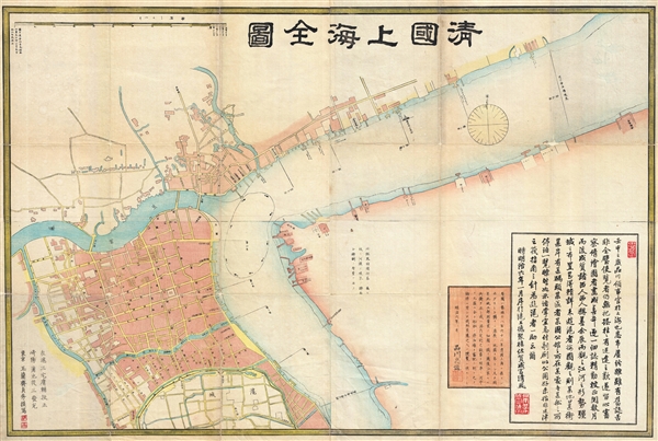
清國上海全圖 / Shinkoku shanhai zenzu. / Qīng guó shànghǎi quán tú. / Qing Shanghai Full Map.
1873 (dated) 26 x 39 in (66.04 x 99.06 cm) 1 : 6500
1873 (dated) 26 x 39 in (66.04 x 99.06 cm) 1 : 6500
Description
An extraordinary discovery, this is the first Japanese map of Shanghai, China, and one of the earliest printed maps of Shanghai. Published in 1873, or Meiji 6, this large format map covers Qing Shanghai's old foreign district. From the conflux of the Huangpu River and the Wusong River, the map extends westward to, roughly, the modern day Xisang Middle Road, south to, roughly, Fangbang Middle Road, and eastward along the Huangpu River to the Dalian Road Tunnel.
This map was commissioned by Shinagawa Tadamichi (1841 - 1891), the first Japanese consul-general of Shanghai, who was appointed by the Meiji government one year earlier in January of 1872. To paraphrase from vice-counsel Seifu Naritomi's (1838 - 1882) introductory text in the lower right-hand corner,
This map was commissioned by Shinagawa Tadamichi (1841 - 1891), the first Japanese consul-general of Shanghai, who was appointed by the Meiji government one year earlier in January of 1872. To paraphrase from vice-counsel Seifu Naritomi's (1838 - 1882) introductory text in the lower right-hand corner,
Mr. Shinagawa suffered greatly from the complexities of Shanghai. Old records, though they did exist, were piecemeal and did not capture the whole. As a result, they left the viewer with little certainty but often the annoyance of getting lost.Tadamichi commissioned the Japanese artist and view maker Sadahide Hashimoto (橋本貞秀) (1807 - 1878) to produce this large map of Shanghai. Hashimoto based the outline of the map on a British port survey composed by J. Minett Hockly, the Shanghai British Settlement's Harbor Master from c. 1866 to his death in 1868. This was then reformatted, expanded, and revised into a city plan by Yosuke Miyake. According to Naritomi,
The end product was of a quality commensurate with Western standards, and praised by Westerners. It displayed, in very elaborate details, the river's situation and the terrain's layout. A person who has never traveled in Shanghai can see at a glance, as if on one's own palm, which areas are called which streets, which river banks have which piers, which district contains which foreign country's mansions, etc. The urgency with which the map was then sent to the engraver was apropos, as it would serve the public interest and help those who travel to Shanghai.This map was engraved and printed by Kamachi Jūzō (1840 - 1891). We are aware of only two known examples of this rare and significant map: the present example and another in Tokyo's National Diel Library. A once in a lifetime opportunity for the serious Shanghai collector.
CartographerS
Shinagawa Tadamichi (品川忠道; December 19, 1841 - 1891) was a Japanese diplomat active in Japan and China during the second half of the 19th century. He was born in Nagasaki and began his career as a Dutch interpreter before entering the Ministry of Public Affairs. From August of 1872, he was Japan's first Consul-General in Shanghai, China. The Sino-Japanese Friendship Treaty (Sino-Japanese Amity Regulations) established formal diplomatic relations between China and Meiji Japan in 1871. One year later, on January 29 of 1872, the Meiji government opened an embassy in Beijing, and a consulate in Shanghai. Shinagawa Tadamichi was appointed to be the first Japanese Consul-General of Shanghai. More by this mapmaker...
Sadahide Hashimoto (橋本貞秀; ハシモト, サダヒデ; 1807 - 1878), also known as Gountei Sadahide (五雲亭貞秀) and Hashimoto Gyokuran (橋本玉蘭), was a Japanese artist active in Yokohama in the second half of the 19th century. He was born in Chiba Prefecture. Hashimoto is best known for his renderings of foreigners, in particular Western peoples and customs, as observed while living in the open port of Yokohama. He is considered to be a disciple of Takako Kunisada, another artist of the Toyokuni Utagawa school, earning him the name Utagawa Sadahide (歌川貞秀). Hashimoto met Kunisada in 1826, when he was 14 years old and most of his early work reflects the work of Kunisada. Even before the Bankumatsu period, Sadahide took an interest in distant and foreign lands, publishing an important and controversial account of the First Opium War between Britain and Qing China (Kaigai Shinwa, 海外新話) with the scholar Mineta Fūkō (嶺田楓江). Following the 'opening of Japan' in 1853, he produced a series of prints of Ainu people in Kita Ezo zusetsu (北蝦夷図説) as well as a world map that was likely based on a Dutch original (https://www.geographicus.com/P/AntiqueMap/world-mineta-1853), also with Mineta. He developed an interest in geography and began issuing maps and bird's-eye views, some quite large over multiple panels, of Japanese cities. At the very end of the Tokugawa period, he moved to Nagasaki and was selected as part of a Japanese delegation to the International Exposition of 1867. Sadahide died about a decade later, living long enough to see the rapid transofrmation of Japan following the Meiji Restoration. He was a mentor to Hideki Utagawa. Learn More...
Condition
Very good. Minor verso restoration and reinforcement. Some wear and foiling on fold lines.
References
OCLC 675613708.