1945 Royal Navy Map of Shanghai Harbor and the Huangpu River, China
ShanghaiHarbour-royalnavy-1945$300.00

Title
Shanghai Harbour.
1945 (undated) 7.5 x 16.75 in (19.05 x 42.545 cm) 1 : 36000
1945 (undated) 7.5 x 16.75 in (19.05 x 42.545 cm) 1 : 36000
Description
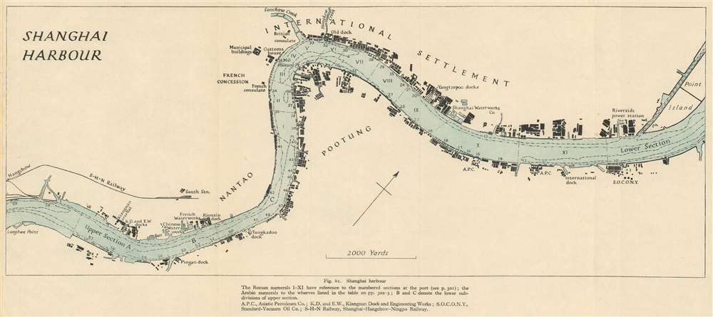
This is a 1945 Royal Naval Intelligence Division map of Shanghai Harbor and the Huangpu (Whangpoo) River in Shanghai, China. The map was issued to as part of a British intelligence report to commissioned assess the future of Chinese-British relations. With the concessions retroceded to China and an violent civil war raging through the countryside, the future of Shanghai as an international hub of commerce was very much in question. Centered on the Bund, International Settlement, and French Concession, the map depicts the Huangpu from Lunghwa Point to Point Island. Numerous buildings appear along both riverbanks, but only a handful of these are identified. The British consulate, French Consulate, and Customs House appear, as do several different docks, the Shanghai Waterworks Company, and the Riverside power station. The numbers along both banks reference specific wharves.
Shanghai After World War II and the End of Extraterritoriality
Published near the end of the war, this map provides a glimpse at an era often overlooked in Chinese history: the years between the end of World War II (1939 - 1945) and the Communist Revolution of 1949. Shanghai was still reeling from years of brutal Japanese occupation - which ended one year before this map was published. During the war, the British, American, and French concessions suffered under the Japanese occupation and were ultimately ended. The British and American concessions were terminated in 1943 when the International Settlement was retroceded to China. The French retained their concession until 1946, one year after the war, when it too was retroceded.The Bigger Picture
China itself was in the midst of a Civil War between the Kuomintang (KMT) government of the Republic of China and the Mao's Communist revolutionaries. With the end of extraterritoriality in Shanghai, the destruction of the Japanese occupation, and the destabilizing effects of the Kuomintang-Communist Civil War, foreign residents and businesses fled Shanghai for safer harbors in Hong Kong and elsewhere. When the Chinese Communist Party finally took control of Shanghai in 1949, just four years after this map was issued, foreign influence and investment was systematically terminated.Publication History and Census
This map was created by the Royal Naval Intelligence Division and published in China Proper - Economic Geography, Ports and Communications in 1945. Although the separate map is uncatalogued in OCLC, the book is well represented in institutional collections.Source
Royal Naval Intelligence Division., China Proper - Economic Geography, Ports and Communications. 1945.
Condition
Very good. Even overall toning. Light wear along original fold lines.