1955 People's Art Publishing Art Deco Map of Shanghai, China
ShanghaiSightSeeing-peoplesart-1955$600.00

Title
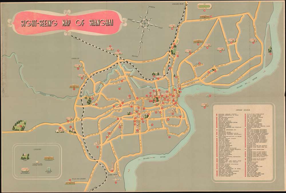
Sight-Seeing Map of Shanghai.
1955 (undated) 20 x 30 in (50.8 x 76.2 cm) 1 : 65000
1955 (undated) 20 x 30 in (50.8 x 76.2 cm) 1 : 65000
Description
A charming c. 1955 art deco map of Shanghai, China, issued for tourists by the Shanghai People's Art Publishing House and the China International Tourist Service. The map centers on the historical business district of Shanghai, including the old concession area, but extends north as far as Chiang Wan, south to encompass Long Hua Airport, and west as far as what is described as 'West Suburban Park', which most likely corresponds to the modern day location of Shanghai Zoo. The map tackles the urban complexity of Shanghai with a minimalist aesthetic that removes unnecessary details (such as minor roads) but highlights important locations with indexed pictorial vignettes. There are some 95 indexed sites, but we are not sure how easy it would be to actually get to one of the locations cited using this map, especially those in Pudong, which are apparently inaccessible by any roadway. The map folds into its original binder which is illustrated with a sapan (Chinese sailboat) in front of the Bund.
The Bund
The Bund is a waterfront area in central Shanghai. The name is derived from the old German term, 'bund,' meaning simply embankment or causeway. Many Asian colonial cities supported a Bund, but none became more famous or iconic than the Shanghai Bund. The area centers on the section of Zhongshan Road within the former Shanghai International Settlement, which runs along the western bank of the Huangpu River, facing Pudong, in the eastern part of Huangpu District. The Bund usually refers to the buildings and wharves on this section of the road, as well as some adjacent area. It is one of the most famous tourist destinations in Shanghai and a designated historic zone.Historic Architecture
Lining the Huangpu River, the Shanghai Bund has dozens of historical buildings that once housed important banks and trading housing from the United Kingdom, France, United States, Italy, Russia, Germany, Japan, Netherlands and Belgium, as well as the consulates of Russia and Britain, a newspaper, the Shanghai Club and the Masonic Club. The Bund lies north of the old walled city of Shanghai and was initially a British settlement. A building boom at the end of the 19th century and the beginning of the 20th century led to the Bund becoming the major financial hub of East Asia. The former French Bund, east of the walled city was formerly more a working harbor.Publication History and Census
This map was published c. 1955 by the Shanghai People's Art Publishing House and the China International Tourist Service. While undated, some of the content helps us narrow the date. The use of the term 'Shanghai Mansions' to describe the Broadway Mansions suggest it must date from 1951 - 1969, during which time the name was in use. Likewise, Longhau airport was used only from 1949 to 1966. As well, the Sino-Soviet Friendship Center was a popular attraction in the 1950s.Cartographer
Shanghai People's Art Publishing House (1952 - Present) is a state-run Shanghai-based Chinese publishing company closely associated with the Chinese Communist Party. The firm was formed in 1952, when privates Shanghai publishers were reorganized into separate organizations, the East China People's Art Press and New Art Press. The name Shanghai People's Art Publishing House in 1954. A year later, in 1955 the New Art Press as absorbed into the Shanghai People's Art Publishing House. The firm remains active today and publishes regime-supported art and literature. In more recent years, it became known as the birthplace of Chinese comics. More by this mapmaker...
Condition
Good. Attached to original binder. Minor wear on original fold lines. Even toning.