This item has been sold, but you can get on the Waitlist to be notified if another example becomes available, or purchase a digital scan.
1940 Fusazō Sugie Map of Shanghai w/International Settlement and Yangpu
ShanghaiYangpu-fusazosugie-1940$625.00

Title
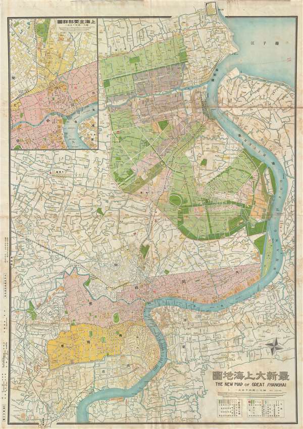
最新大上海地圖 / The New Map of Great Shanghai. / Saishin dai Shanhai chizu.
1940 (dated) 42 x 30 in (106.68 x 76.2 cm) 1 : 24000
1940 (dated) 42 x 30 in (106.68 x 76.2 cm) 1 : 24000
Description
This is a scarce 1940 Shōwa 15 Fusazō Sugie Japanese issue map of Shanghai, China. The map follows the course of the Hunagpu River from Baoshan and its convergence with the Yangtze south to, roughly, Dama Jiazhai. Color coding emphasized the focus of the map. The International Settlement is in pink, the French Concession is in Yellow. An area to the north roughly corresponding to the modern day Yangpu District is in green and pink. The Yangpu District, was, from the early 20th century, an industrial zone primarily controlled by Japanese merchants based in the neighboring Hongkou District. During the Japanese occupation, 1937 to 1945, there was increased interest in developing the region and barracks and housing was constructed there. An earlier version of this map appeared in the 1930s, but was limited to only the bottom half, focusing in the French Concession and the International Settlement. The expansion of the map to include the Yangpu district doubtless reflects expanding Japanese interest in this region.
It is of note that the lower portion of the map is bi-lingual, but the upper portion is exclusively in Chinese. The exception is an inset in upper left quadrant detailing the northern Bund region and the most developed part of the International Settlement centered on the conjunction of the Hunagpu and Wusong Rivers (Suzhou Creek). The inset identifies individual buildings, important factories, hotels, wharves, and more. The sites of various battles associated with the Battle of Shanghai (1937) are also noted.
The map was drawn from a variety of different sources, including new surveys done by the Japanese. The portion of the map focusing on the International Settlement and the French Concession is based upon a 1927 map, also by Sugie Fusazō (杉江房造). There are at least three editions of this map, the present being the second, published in 1940, or Shōwa 15. The first edition appeared in 1939, Shōwa 14. A third edition, published in 1943 Shōwa 18, is known to have been made. There may be others. The map, as here, is rare. The OCLC identifies only 2 other known examples, at the University of Hong Kong and at Harvard.
Cartographer
Fusazō Sugie (杉江房造; fl. c. 1910 – 1950) was a Japanese bookseller, printer, and active in Shanghai during the final years of the Qing. Fusazō was the owner of the Nihon-do Japanese Bookstore (日本堂書店) in Shanghai, located at 155 Hong-Kou-Wen Street and 237 Woosung Road. He issued numerous guidebooks, souvenir photo books, and maps associated with Shanghai and Nanjing, many of which were bilingual and marketed to American and European tourists and servicemen. His bilingual New Map of Shanghai, published in various states and editions from 1931 well into the 1940s, is his most notable cartographic work. More by this mapmaker...
Condition
Very good. Wear on original fold lines.
References
OCLC 80623896. Harvard University, HOLLIS 014560183.