1949 War Office Map of Sham Chun (Shenzhen) - Hong Kong Border
ShaTauHK-waroffice-1949$850.00


Title
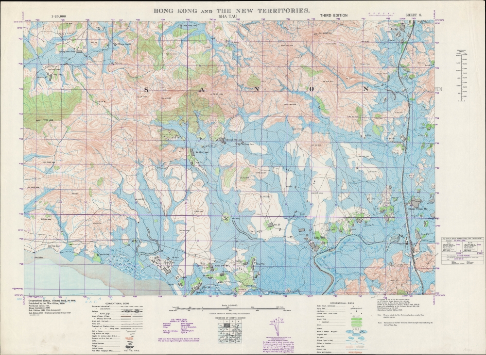
Hong Kong and the New Territories. Sha Tau.
1949 (dated) 25.25 x 34.5 in (64.135 x 87.63 cm) 1 : 20000
1949 (dated) 25.25 x 34.5 in (64.135 x 87.63 cm) 1 : 20000
Description
A 1949 British War Office topographic map of a portion of the border between Hong Kong and Bao'an County, today's Shenzhen Municipality. The bottom portion of the map includes the border between Hong Kong's New Territories and mainland China, which took on new significance with the establishment of the People's Republic of China the same year of this map's production.
Sham Chun Hu (深圳墟) was the historic market town of Shenzhen and the origin of the placename now known throughout the world. At the time of this map's production, it had several tens of thousands of residents and was an important stop on the Canton-Kowloon Railway, which runs north-south at right. With the victory of the Communists in 1949, the railway had to adapt to the new political reality on the mainland, for instance by adding a station at the border along the Sham Chun River, which is referred to here as lying north of the river / border but ultimately sat on the southern side of the border. In subsequent years, a road called 'Border Road' was added along the southern side of the river, an automobile bridge (the first) over the Sham Chun River built, and the Man Kam To Control Point constructed. The Canton-Kowloon Railway Line continued to operate through the Maoist period, albeit with strict and cumbersome border control procedures, and has been incorporated into the Hong Kong MTR (Mass Transit Railway) system, with a new station at Luo Wu on the Hong Kong side of the border opened in 1987.
Even prior to the Communist victory in 1949, the border represented a crossing point between two legal and economic regimes. A customs station can be seen on the northern side of the border near the railway. In the 1930s - 1940s, though distracted by fighting a Communist revolution and a Japanese invasion, the Nanjing Government led by Chiang Kai-Shek invested considerable resources into controlling cross-border smuggling, with the border between Hong Kong and mainland China being one of their main areas of concern (for context, see Philip Thai's 2018 book China’s War on Smuggling: Law, Economic Life, and the Making of the Modern State, 1842 - 1965).
Aside from the border and the aforementioned towns and villages, this area has changed drastically in the past forty years, as Shenzhen was designated a Special Economic Zone open to trade and investment. Being right along the border with Hong Kong, Futian District was given special attention and now houses many government buildings as well as the city's Central Business District. Luohu has developed a reputation as a fashionable shopping and nightlife district.
The United Kingdom was the earliest Western power to recognize the People's Republic of China, in January 1950, in a bid to protect Hong Kong. Still, it was not at all clear that Hong Kong would be safe from a Communist invasion, and Britain was hardly in a position to try to defend the colony at the time. We now know that part of the reason the Communists left Hong Kong alone is because it served a vital function as a window to the capitalist world, allowing, for instance, the evasion of a U.S. blockade to receive critical supplies during the Korean War. Though tens of thousands of refugees fled the mainland for Hong Kong in the late 1940s, the border between Hong Kong and China was quite open in the early-mid 1950s, allowing Hong Kong residents to travel to their home villages and visit relatives. Though this 'travel,' often an excuse for trading, was a thorn in the side of the Communists, who were attempting to institute a strict customs regime and control the flow of precious metals to support the renminbi, it also was an economic boon, especially to Guangdong and Fujian provinces.
A Closer Look
Coverage includes what is today the southern portion of Shenzhen Municipality, corresponding with Futian and Luohu Districts (the village of Luo Fu here is likely the contemporary English transliteration of the Cantonese pronunciation of the placename's characters 罗湖). The Sham Chun (Shenzhen) River runs west-east along the bottom of the map, constituting the border between the New Territories of Hong Kong and mainland China. Although the area has been completely transformed since 1980, some placenames remain in use; for instance, there is still a Shatou (or Sha Tau, 沙头) neighborhood in Futian District at the location of the village seen here.Sham Chun Hu (深圳墟) was the historic market town of Shenzhen and the origin of the placename now known throughout the world. At the time of this map's production, it had several tens of thousands of residents and was an important stop on the Canton-Kowloon Railway, which runs north-south at right. With the victory of the Communists in 1949, the railway had to adapt to the new political reality on the mainland, for instance by adding a station at the border along the Sham Chun River, which is referred to here as lying north of the river / border but ultimately sat on the southern side of the border. In subsequent years, a road called 'Border Road' was added along the southern side of the river, an automobile bridge (the first) over the Sham Chun River built, and the Man Kam To Control Point constructed. The Canton-Kowloon Railway Line continued to operate through the Maoist period, albeit with strict and cumbersome border control procedures, and has been incorporated into the Hong Kong MTR (Mass Transit Railway) system, with a new station at Luo Wu on the Hong Kong side of the border opened in 1987.
Even prior to the Communist victory in 1949, the border represented a crossing point between two legal and economic regimes. A customs station can be seen on the northern side of the border near the railway. In the 1930s - 1940s, though distracted by fighting a Communist revolution and a Japanese invasion, the Nanjing Government led by Chiang Kai-Shek invested considerable resources into controlling cross-border smuggling, with the border between Hong Kong and mainland China being one of their main areas of concern (for context, see Philip Thai's 2018 book China’s War on Smuggling: Law, Economic Life, and the Making of the Modern State, 1842 - 1965).
Aside from the border and the aforementioned towns and villages, this area has changed drastically in the past forty years, as Shenzhen was designated a Special Economic Zone open to trade and investment. Being right along the border with Hong Kong, Futian District was given special attention and now houses many government buildings as well as the city's Central Business District. Luohu has developed a reputation as a fashionable shopping and nightlife district.
The Frontier Closed Area
In 1951, in an effort to control cross-border migration and trade (smuggling), the British administration of Hong Kong established a Frontier Closed Area along the border between Hong Kong and mainland China. Except for travelers between the two territories, who needed a visa, anyone within the closed area required a special permit. Curfews were imposed and the rudimentary fence between Hong Kong and Bao'an was gradually supplemented by a sturdier and more imposing second fence, complete with barbed wire. Controls were relaxed in the 1980s as relations between China and Great Britain improved, leading to the handover of Hong Kong to Chinese sovereignty in 1997, but the Frontier Closed Area continues to exist, and permits are still required for anyone in the area along most parts of the border.Historical Context
This map was one part of a 24-sheet survey map series of Hong Kong, first undertaken in 1928 - 1930 and updated periodically thereafter. This ambitious undertaking was no doubt one of the largest, if not the largest, topographical surveys of Hong Kong at the time. The updates made after the Second World War (2nd and 3rd editions) were no doubt motivated by taking stock after the city's occupation by the Japanese. But the third edition in 1949 also coincides with the Communist revolution in mainland China, which presented a serious threat to the colony.The United Kingdom was the earliest Western power to recognize the People's Republic of China, in January 1950, in a bid to protect Hong Kong. Still, it was not at all clear that Hong Kong would be safe from a Communist invasion, and Britain was hardly in a position to try to defend the colony at the time. We now know that part of the reason the Communists left Hong Kong alone is because it served a vital function as a window to the capitalist world, allowing, for instance, the evasion of a U.S. blockade to receive critical supplies during the Korean War. Though tens of thousands of refugees fled the mainland for Hong Kong in the late 1940s, the border between Hong Kong and China was quite open in the early-mid 1950s, allowing Hong Kong residents to travel to their home villages and visit relatives. Though this 'travel,' often an excuse for trading, was a thorn in the side of the Communists, who were attempting to institute a strict customs regime and control the flow of precious metals to support the renminbi, it also was an economic boon, especially to Guangdong and Fujian provinces.
Publication History and Census
This map was initially produced by the British War Office in 1928, incorporating surveys undertaken by the Royal Air Force and Royal Engineers. Corrections were added in 1934 and 1939, a second edition was issued in 1945, and this third edition appeared in 1949, with assistance from the Ordnance Survey (subsequent editions were produced in 1952, 1957, and 1969). This is the 6th Sheet in a series of 24 (a diagram of the full survey is included at bottom-center). The map is only independently cataloged with the University of Hong Kong, while the National Library of Australia holds the entire series consisting of various editions of the maps which are unclear from the catalog listing.CartographerS
The British War Office (1857 - 1964) was a department of the British Government responsible for the administration of the Royal Army until 1964, when its functions were transferred to the Ministry of Defense. The War Office was to the Royal Army what the Admiralty was to the Royal Navy, and later, the Air Ministry. Within the War Office, the General Staff Topographical Section was responsible for thousands of maps issued for British intelligence and military use. The Topographical Section was renamed Geographical Section in April 1907. Many, once their military use passed, were offered through licensed agents to the general public. The sole London agent for War Office material was Edward Stanford. More by this mapmaker...
The British Ordnance Survey (1791 - present) is the national mapping agency of Great Britain and is one of the largest producers of maps in the world. This non-ministerial department of the government of the United Kingdom is responsible for producing maps of Great Britain and many of its overseas possessions. The history of the Ordnance Survey goes back as far as 1747, following the Jacobite rising, when King George II commissioned a comprehensive military survey of Scotland to assist further campaigns. The result, produced by Paul Sandby, John Mason and William Roy, was the Duke of Cumberland's Map, the first military quality map of the British Isles. This grew into the Principal Triangulation of Great Britain (1783-1853) under William Roy, and eventually lead to the creation of the Ordnance Survey in 1791. Today the Ordnance Survey produces a large variety of paper maps and digital mapping products. Its large scale maps, issued to the scale of 1:10000, available in sheet map form until the 1980s, are now only available digitally. All maps produced by the Ordnance Survey are in copyright for 50 years after publication. Learn More...
Condition
Very good. Minor creasing in the margins.
References
OCLC 49387021.