1949 War Office Map of Sha Tau Kok / Shatoujiao, Shenzhen - Hong Kong Border
ShaTauKokHK-waroffice-1949$750.00


Title
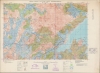
Hong Kong and the New Territories. Sha Tau Kok.
1949 (dated) 25.25 x 34.5 in (64.135 x 87.63 cm) 1 : 20000
1949 (dated) 25.25 x 34.5 in (64.135 x 87.63 cm) 1 : 20000
Description
A detailed large-format map of the easternmost portion of the land border between Hong Kong and Shenzhen (then Bao'an County), produced in 1949 by the British War Office. Though a long distance from Hong Kong Island, the border crossing at Sha Tau Kok (or Shatoujiao) has emerged as one of the main crossing points between Hong Kong and the mainland in the past forty years.
The Kowloon Customs Station seen at Shatoujiao, along with two Chinese Customs Stations, the Ling Ma Hang Police Station, and the Ta Ku Ling Police Station further west, reflect the (often futile) efforts of both the Chinese Nationalist Government and the Hong Kong authorities to control smuggling. In the 1930s - 1940s, though distracted by fighting a Communist revolution and a Japanese invasion, the Nanjing Government led by Chiang Kai-Shek invested considerable resources into controlling cross-border smuggling, with the border between Hong Kong and mainland China being one of their main areas of concern (for context, see Philip Thai's 2018 book China’s War on Smuggling: Law, Economic Life, and the Making of the Modern State, 1842 - 1965). Since Shenzhen's designation as a special economic zone, a border control point was established in 1985 to manage the increased trade and migration crossing over at Shatoujiao.
Aside from the border and related features, villages, irrigated fields, roads, footpaths, topography, and more are indicated in remarkable detail. Though not a nautical chart, the map does include fathoms, hazards, and other maritime features. To the east of the road leading to Shatoujiao / Sha Tau Kok, on the shore of Starling Inlet, a Tin Hau Temple is noted. Tin Hau (known in Mandarin as Mazu), is a sea goddess known as the protector of mariners who was traditionally worshipped all along the south Chinese coast.
The United Kingdom was the earliest Western power to recognize the People's Republic of China, in January 1950, in a bid to protect Hong Kong. Still, it was not at all clear that Hong Kong would be safe from a Communist invasion, and Britain was hardly in a position to try to defend the colony at the time. We now know that part of the reason the Communists left Hong Kong alone is because it served a vital function as a window to the capitalist world, allowing, for instance, the evasion of a U.S. blockade to receive critical supplies during the Korean War. Though tens of thousands of refugees fled the mainland for Hong Kong in the late 1940s, the border between Hong Kong and China was quite open in the early-mid 1950s, allowing Hong Kong residents to travel to their home villages and visit relatives. Though this 'travel,' often an excuse for trading, was a thorn in the side of the Communists, who were attempting to institute a strict customs regime and control the flow of precious metals to support the renminbi, it also was an economic boon, especially to Guangdong and Fujian provinces.
A Closer Look
Coverage includes what is today the southeastern portion of Shenzhen Municipality, corresponding with Luohu and Yantian Districts, and the North District of Hong Kong. The Sham Chun (Shenzhen) River runs west-east along the center of the map, constituting the border between the New Territories of Hong Kong and mainland China. The map's title comes from Sha Tau Kok (or Shatoujiao, 沙頭角), a name used for both sides of the easternmost land portion of the border, which has been significantly elaborated in recent years, stretching on the mainland Chinese side to the edge of the area seen here, especially since the Shenzhen Shatoujiao Free Trade Zone was established in 1987. Aside from the border crossing and adjacent towns, much of the land seen here remains undeveloped and is protected as parkland, crisscrossed with hiking trails. To the west of Ng Tung Shan (Mt. Wutong), a reservoir was built in 1965 and remains the largest manmade lake in Shenzhen Municipality.The Kowloon Customs Station seen at Shatoujiao, along with two Chinese Customs Stations, the Ling Ma Hang Police Station, and the Ta Ku Ling Police Station further west, reflect the (often futile) efforts of both the Chinese Nationalist Government and the Hong Kong authorities to control smuggling. In the 1930s - 1940s, though distracted by fighting a Communist revolution and a Japanese invasion, the Nanjing Government led by Chiang Kai-Shek invested considerable resources into controlling cross-border smuggling, with the border between Hong Kong and mainland China being one of their main areas of concern (for context, see Philip Thai's 2018 book China’s War on Smuggling: Law, Economic Life, and the Making of the Modern State, 1842 - 1965). Since Shenzhen's designation as a special economic zone, a border control point was established in 1985 to manage the increased trade and migration crossing over at Shatoujiao.
Aside from the border and related features, villages, irrigated fields, roads, footpaths, topography, and more are indicated in remarkable detail. Though not a nautical chart, the map does include fathoms, hazards, and other maritime features. To the east of the road leading to Shatoujiao / Sha Tau Kok, on the shore of Starling Inlet, a Tin Hau Temple is noted. Tin Hau (known in Mandarin as Mazu), is a sea goddess known as the protector of mariners who was traditionally worshipped all along the south Chinese coast.
The Frontier Closed Area
In 1951, in an effort to control cross-border migration and trade (smuggling), the British administration of Hong Kong established a Frontier Closed Area along the border between Hong Kong and mainland China. Except for travelers between the two territories, who needed a visa, anyone within the closed area required a special permit. Curfews were imposed and the rudimentary fence between Hong Kong and Bao'an was gradually supplemented by a sturdier and more imposing second fence, complete with barbed wire. Controls were relaxed in the 1980s as relations between China and Great Britain improved, leading to the handover of Hong Kong to Chinese sovereignty in 1997, but the Frontier Closed Area continues to exist, and permits are still required for anyone in the area along most parts of the border.Historical Context
This map was one part of a 24-sheet survey map series of Hong Kong, first undertaken in 1928 - 1930 and updated periodically thereafter. This ambitious undertaking was no doubt one of the largest, if not the largest, topographical surveys of Hong Kong at the time. The updates made after the Second World War (2nd and 3rd editions) were no doubt motivated by taking stock after the city's occupation by the Japanese. But the third edition in 1949 also coincides with the Communist revolution in mainland China, which presented a serious threat to the colony.The United Kingdom was the earliest Western power to recognize the People's Republic of China, in January 1950, in a bid to protect Hong Kong. Still, it was not at all clear that Hong Kong would be safe from a Communist invasion, and Britain was hardly in a position to try to defend the colony at the time. We now know that part of the reason the Communists left Hong Kong alone is because it served a vital function as a window to the capitalist world, allowing, for instance, the evasion of a U.S. blockade to receive critical supplies during the Korean War. Though tens of thousands of refugees fled the mainland for Hong Kong in the late 1940s, the border between Hong Kong and China was quite open in the early-mid 1950s, allowing Hong Kong residents to travel to their home villages and visit relatives. Though this 'travel,' often an excuse for trading, was a thorn in the side of the Communists, who were attempting to institute a strict customs regime and control the flow of precious metals to support the renminbi, it also was an economic boon, especially to Guangdong and Fujian provinces.
Publication History and Census
Though not stated here, this map was initially produced by the British War Office in 1928 or 1929, incorporating surveys undertaken by the Royal Air Force and Royal Engineers. Corrections were added in 1934 and 1939, a second edition was issued in 1945, and this third edition appeared in 1949 (so labelled at top, at bottom-left it is said to be the fourth edition), with assistance from the Ordnance Survey (subsequent editions were produced in 1952, 1957, and 1969). This is the 7th Sheet in a series of 24 (a diagram of the full survey is included at bottom-center). This edition of the map is not independently cataloged with any institution, while the National Library of Australia holds the entire series consisting of various editions of the maps which are unclear from the catalog listing.CartographerS
The British War Office (1857 - 1964) was a department of the British Government responsible for the administration of the Royal Army until 1964, when its functions were transferred to the Ministry of Defense. The War Office was to the Royal Army what the Admiralty was to the Royal Navy, and later, the Air Ministry. Within the War Office, the General Staff Topographical Section was responsible for thousands of maps issued for British intelligence and military use. The Topographical Section was renamed Geographical Section in April 1907. Many, once their military use passed, were offered through licensed agents to the general public. The sole London agent for War Office material was Edward Stanford. More by this mapmaker...
The British Ordnance Survey (1791 - present) is the national mapping agency of Great Britain and is one of the largest producers of maps in the world. This non-ministerial department of the government of the United Kingdom is responsible for producing maps of Great Britain and many of its overseas possessions. The history of the Ordnance Survey goes back as far as 1747, following the Jacobite rising, when King George II commissioned a comprehensive military survey of Scotland to assist further campaigns. The result, produced by Paul Sandby, John Mason and William Roy, was the Duke of Cumberland's Map, the first military quality map of the British Isles. This grew into the Principal Triangulation of Great Britain (1783-1853) under William Roy, and eventually lead to the creation of the Ordnance Survey in 1791. Today the Ordnance Survey produces a large variety of paper maps and digital mapping products. Its large scale maps, issued to the scale of 1:10000, available in sheet map form until the 1980s, are now only available digitally. All maps produced by the Ordnance Survey are in copyright for 50 years after publication. Learn More...
Condition
Very good. Minor creasing in the margins.