This item has been sold, but you can get on the Waitlist to be notified if another example becomes available, or purchase a digital scan.
1720 Van Keulen Flag Chart w/Pirate Flags
SheepsValggen-vankeulen-1720$2,125.00

Title
Schouw-park aller Scheeps-Vlaggen des geheelen Water-Waerelds… / Tableau des Pavillons de Meer, qui se trouvent dans tous les lieux du Monde Aquatique- Augmenté… / A New Table of all the Ships, collors or Ensigns in the Wholl Water World.
1720 (undated) 20 x 30 in (50.8 x 76.2 cm)
1720 (undated) 20 x 30 in (50.8 x 76.2 cm)
Description
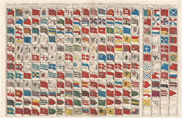
This is an extraordinary and exceedingly rare separate issue c. 1720 flag chart by Gerard van Keulen featuring the pirate flag of Christopher Moody, the Berber's Head Barbary pirate ensign, and the ephemeral New England Globe Flag, among other interesting pavillons. In addition, the chart includes flags for various trading companies, including the Dutch East India Company (VOC, Verenigde Oostindische Compagnie) and the Dutch West India Company (WIC, Geoctroyeerde Westindische Compagnie). The chart moreover also accommodates the addition of new ensigns by leaving seven blank flags in the lower right.
Van Keulen's chart is actually two charts printed on a single sheet from separate plates. The left chart, occupying four-fifths of the sheet, is derived from the Petrus Schenk flag chart of 1811. The right chart, curiously titled in English, and printed from a separate plate, is new and was probably added by Van Keulen to supplement the 1711 plate.
This chart's most historically significant element is its illustration of the ephemeral New England Globe Flag, one of the earliest New England flags and in fact one of the earliest examples of a fully American flag. This flag is located in the upper right corner of the primary plate. This flag and its appearance on this chart is described in the Rhode Island Historical Society Collections (January 1930, Volume XXIII, page 97):
The chart also contains two pirate flags. The most interesting, located in the lower left corner, is the flag of the Christopher Moody (1694–1722). Moody was an early 18th-century pirate active nearly the coast of the Carolinas. He had a bloody reputation and was known for sparing no lives. Moody is often reported as a member of Bartholomew Roberts' crew but this is unverifiable. After he was captured in 1722 he was hung at Cape Coast Castle in Cabo Corso, Ghana. The distinctive pirate flag, here labeled 'Rovers,' features a winged hourglass, an arm and dagger, and a skull and crossbones on a blood red field. While this flag is commonly attributed to Moody, he may have borrowed it from another unknown earlier pirate.
The second pirate flag appears in the English language addendum to the right of the primary chart. This is the legendary Barbary Pirate Berber's Skull Head Ensign. The flag is uncommon, but has been attributed in several 18h century works, including the present chart, attribute to the Barbary Pirates of Beylerbeyi, Algiers. In some references, the flag of Algiers is represented with a Berber's head, while the flag of the pirates is nearly identical save with a skull, as here.
At bottom center the flag of Empire of China (Sina) stands out. It appears as a great whirlpool surrounded by eight decorations. This is most likely based upon an image of the Chinese flag appearing in Carel Allard's, 1705 Dutch flag book, Niewe Hollandse Scheeps Bouw. In fact, it is a misinterpretation of the Qing flag, a dragon on a yellow field with eight banners. However, Schenk and later Van Keulen, likely having never seen a Chinese flag, interpreted the dragon to the best of his ability.
This chart is extremely rare and undated, but most scholarship places it around 1720. We have been able to identify only 2 other examples in institutional collections, at Yale. The chart may have been republished in Amsterdam around 1725 by Jochem Hasebroek.
Van Keulen's chart is actually two charts printed on a single sheet from separate plates. The left chart, occupying four-fifths of the sheet, is derived from the Petrus Schenk flag chart of 1811. The right chart, curiously titled in English, and printed from a separate plate, is new and was probably added by Van Keulen to supplement the 1711 plate.
This chart's most historically significant element is its illustration of the ephemeral New England Globe Flag, one of the earliest New England flags and in fact one of the earliest examples of a fully American flag. This flag is located in the upper right corner of the primary plate. This flag and its appearance on this chart is described in the Rhode Island Historical Society Collections (January 1930, Volume XXIII, page 97):
The first dated reference to the globe flag seems to be in the 'Schouw-Park aller Scheeps-Vlaggen' or 'Tableau des Pavilions de Mer,' which was published by Pieter Schenk at Amsterdam in 1711. The New England flag is shown hand colored and with the colors also shown by tincture lines, as a blue flag, having a white canton with a red cross and with a globe on a standard in the first quarter of the canton. The globe is outlined in black, but no color is specified. No reference to this globe flag has been found in any contemporary English or American writings…New England had several early flags. The earliest, was the flag of the Massachusetts Bay Colony, a white canton on a red field, of which there are no surviving illustrations. The flag changed c. 1686 to include St. George's Cross and a pine or oak tree in the upper left quadrant. The oak tree was reinterpreted as a globe and the field changed to blue around 1711, when this chart was issued, making one of the earliest, if not the first, printed illustration of the Globe Flag of New England.
The chart also contains two pirate flags. The most interesting, located in the lower left corner, is the flag of the Christopher Moody (1694–1722). Moody was an early 18th-century pirate active nearly the coast of the Carolinas. He had a bloody reputation and was known for sparing no lives. Moody is often reported as a member of Bartholomew Roberts' crew but this is unverifiable. After he was captured in 1722 he was hung at Cape Coast Castle in Cabo Corso, Ghana. The distinctive pirate flag, here labeled 'Rovers,' features a winged hourglass, an arm and dagger, and a skull and crossbones on a blood red field. While this flag is commonly attributed to Moody, he may have borrowed it from another unknown earlier pirate.
The second pirate flag appears in the English language addendum to the right of the primary chart. This is the legendary Barbary Pirate Berber's Skull Head Ensign. The flag is uncommon, but has been attributed in several 18h century works, including the present chart, attribute to the Barbary Pirates of Beylerbeyi, Algiers. In some references, the flag of Algiers is represented with a Berber's head, while the flag of the pirates is nearly identical save with a skull, as here.
At bottom center the flag of Empire of China (Sina) stands out. It appears as a great whirlpool surrounded by eight decorations. This is most likely based upon an image of the Chinese flag appearing in Carel Allard's, 1705 Dutch flag book, Niewe Hollandse Scheeps Bouw. In fact, it is a misinterpretation of the Qing flag, a dragon on a yellow field with eight banners. However, Schenk and later Van Keulen, likely having never seen a Chinese flag, interpreted the dragon to the best of his ability.
This chart is extremely rare and undated, but most scholarship places it around 1720. We have been able to identify only 2 other examples in institutional collections, at Yale. The chart may have been republished in Amsterdam around 1725 by Jochem Hasebroek.
Cartographer
Gerard van Keulen (1678 - 1726) was a Dutch map publisher and engraver active in Amsterdam during the late 17th and early 18th centuries. Gerard was the son of the more famous Johannes Van Keulen (1654 – 1715) and eventually took over his father's business. He also negotiated to take over the Privilege of Willem Blaeu, thus becoming the official cartographer of the Dutch East India Company (VOC). He was married to Ludowina Konst (16??? - 1740). Gerard is credited with nearly 500 charts and maps published between 1706 and his death in 1726. He also continued to update and republish his family's legendary Zee-Fakkel, often described as the 'Secret Atlas' as it was restricted to VOC pilots. After his death, the firm was passed on to Gerard's son, Johannes II Van Keulen (1704 - 1755), who significantly updated the atlas. The final true Van Keulen editions of the atlas were published by Gerard Hulst Van Keulen (1733 - 1801), Johannes II's son. The final edition of the Zee-Fakkel was published posthumously in 1803. Afterward, the firm fell into the hands of the Swart family, who managed it for several generations until it finally closed its doors in 1885. It is noteworthy that though ostensibly controlled by the Van Keulen men, it was their widows who maintained and managed the firm in the periods following their husbands' deaths. More by this mapmaker...
Condition
Very good. Original platemark. Blank on verso.
References
OCLC 66663315.