This item has been sold, but you can get on the Waitlist to be notified if another example becomes available, or purchase a digital scan.
1966 Edith Shepherd Pictorial Map of Shelter Island, Long Island
ShelterIsland-edithshepherd-1966$325.00

Title
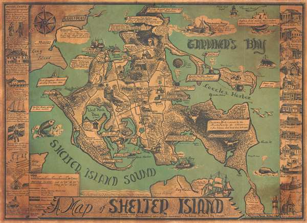
A Map of Shelter Island.
1966 (dated) 19.75 x 27.5 in (50.165 x 69.85 cm) 1 : 18000
1966 (dated) 19.75 x 27.5 in (50.165 x 69.85 cm) 1 : 18000
Description
This is Edith Hawkins Shepherd's rare 1966 pictorial map of Shelter Island, Long Island. Shelter Island is 'sheltered' between the north and south forks of Long Island and retains much of its traditional charm amidst the glam and glitz of Hamptons. Shepherd identifies the basic geography of the island as well as local folklore (the place where Sachem Pogatticut watched the sunset), historical sites (such as the Westmoreland Clock Tower and the site of Lords' Shipyards), and more. The region's agricultural and maritime heritage are emphasized. Even Captain Kidd, the notorious pirate, is noted in the upper right. Historical buildings form sidebars to the left and right of the main map. This map was drawn by the Long Island native Edith Hawkins Shepherd, who lived on Shelter Island, working as secretary for the town planning board, until her death in 2007.
This map appeared in two editions, 1950, and as here 1966. It is rare by any measure. We have seen only two examples and have been able to identify only one example in an institutional collection. A real Long Island rarity.
This map appeared in two editions, 1950, and as here 1966. It is rare by any measure. We have seen only two examples and have been able to identify only one example in an institutional collection. A real Long Island rarity.
Condition
Good. Paper artifically browned by publisher.
References
OCLC 988372213.