1780 Bellin/ Müller Map of Siberia and Kamchatka
Siberia-bellin-1780$450.00
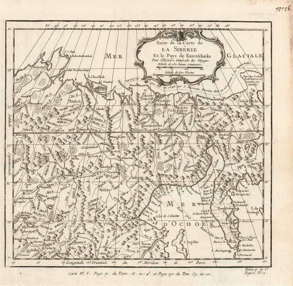

Title
Suite de la Carte de La Siberie Et le Pays de Kamtschatka Pour l'Histoire Générale des Voyages.
1780 (undated) 9.75 x 10.25 in (24.765 x 26.035 cm) 1 : 14500000
1780 (undated) 9.75 x 10.25 in (24.765 x 26.035 cm) 1 : 14500000
Description
This is a beautifully engraved 1780 map of northeastern Asia, including Siberia and the Kamchatka Peninsula. Executed by Bellin, the map's details are drawn from the Asian portions of Gerhard Friedrich Müller's landmark 1754 Nouvelle Carte Des Decouvertes. Although Müller is lionized for its revelations of the voyages of Vitus Bering (1681 - 1741) and Aleksei Chirikov (1703 -1748), it also provided remarkably state-of-the-art details for the northeastern extremes of Siberia and Kamchatka. Müller's map was intended to counter the fraudulent maps produced of the same regions by fellow Academians Joseph-Nicolas De l’Isle (1688 - 1768) and Phillippe Buache (1700 - 1773), and the adoption of his geography by no lesser a figure than Bellin is a sign of his success. While mountains are shown pictorially, the delineation of the Sea of Ochosk, Sakhalin Island and the Kamchatka Peninsula is remarkably accurate. The Tschukschi Peninsula is shown in vague hachure, with a note explaining that its size is not understood.
Semen Ivanovich Dezhnev
Along the top of the map, tracks indicate the route of an unnamed Russian expedition. This is in fact the little-known 1648 voyage of Cossack Semen Ivanovich Dezhnev (1605 - 1673). Dezhnev put together a rough and ready expedition to explore the waterways around northeastern Siberia. His company consisted of Fedot Alekseyev, traveling with the merchants Andreev and Afstaf'iev (representing the Guselnikov merchant house), who provided their own ship, and Gerasim Ankudinov, an experienced sea captain with his own ship and some 30 men. Dezhnev, along with Mikhail Stadukhin, recruited some 19 men of their own and procured a traditional kocha ship. Including escort vessels, a total seven ships sailed from the mouth the Kolyma River, along the Siberian Arctic, to the Anadyr River north of Kamchatka, and in doing so became the first Europeans to sail through the Bering Strait some 80 years before Vitus Bering. Dezhnev described rounding a large mountainous promontory identified as Chukchi, Tschuktschi, or Chukotka Peninsula. Of the seven vessels the multiple leaders, only three ships, including Dezhnev’s, survived the passage. Dezhnev's voyage ultimately proved that there was indeed a nautical route from Russia to East Asia, but at the same time confirmed that it was exceedingly impractical.Publication History and Census
The separate map appears on the market from time to time but is neglected in institutional collections: OCLC lists only four examples of this map. La Harpe's Abrégé de l'histoire générale des voyages is well represented in institutions.CartographerS
Jacques-Nicolas Bellin (1703 - March 21, 1772) was one of the most important cartographers of the 18th century. With a career spanning some 50 years, Bellin is best understood as geographe de cabinet and transitional mapmaker spanning the gap between 18th and early-19th century cartographic styles. His long career as Hydrographer and Ingénieur Hydrographe at the French Dépôt des cartes et plans de la Marine resulted in hundreds of high quality nautical charts of practically everywhere in the world. A true child of the Enlightenment Era, Bellin's work focuses on function and accuracy tending in the process to be less decorative than the earlier 17th and 18th century cartographic work. Unlike many of his contemporaries, Bellin was always careful to cite his references and his scholarly corpus consists of over 1400 articles on geography prepared for Diderot's Encyclopedie. Bellin, despite his extraordinary success, may not have enjoyed his work, which is described as "long, unpleasant, and hard." In addition to numerous maps and charts published during his lifetime, many of Bellin's maps were updated (or not) and published posthumously. He was succeeded as Ingénieur Hydrographe by his student, also a prolific and influential cartographer, Rigobert Bonne. More by this mapmaker...
Gerhard Friedrich Müller (Фёдор Ива́нович Ми́ллер; October 29, 1705 - October 22, 1783), also known as Fyodor Ivanovich Miller, was a Russian-German historian, ethnologist and cartographer. He was born in Herford and educated at Leipzig. In 1725, he was among the European scholars invited to St. Petersburg to co-found the Imperial Academy of Sciences. Müller took part in the Academy's Great Northern Expedition (Second Kamchatka Expedition; 1733 - 1743), he and eighteen scientists and artists traveled the area to perform ethnological and botanical studies, as well as collecting data for the creation of maps. Müller's descriptions and categorizations of clothing, religions and rituals of the Siberian ethnic groups earned him the title 'father of ethnography.' He produced an essential map of the arctic and sub-arctic regions of the Pacific in 1754, motivated to counter the geographic frauds perpetrated by Joseph Nicholas De l’Isle (1688 - 1768) and Phillippe Buache (1700 - 1773). He knew both Vitus Bering (1733 - 1743) and Aleksei Chirikov (1703 - 1748), and was as close to his subject matter as any cartographer of his age. Learn More...
Source
De la Harpe, Abrégé de l'histoire générale des voyages. (Paris) 1780.
Condition
Very good condition. Left margin close but complete. Some soiling at right margin away from printed image. Else excellent with a bold sharp strike.
References
OCLC 635289625.