1744 Harris / Bowen Map of Siberia, Bering's Expeditions
Siberia-harris-1744$350.00

Title
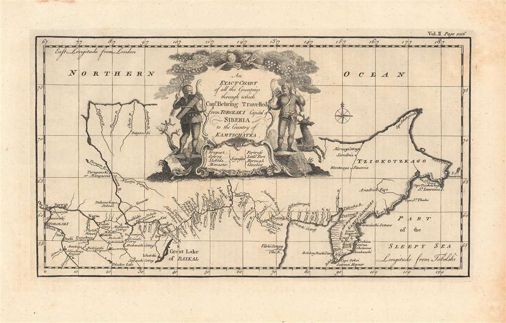
An exact chart of all the countries through which Capt. Behring travelled...
1744 (undated) 7 x 12.75 in (17.78 x 32.385 cm) 1 : 21400000
1744 (undated) 7 x 12.75 in (17.78 x 32.385 cm) 1 : 21400000
Description
This is a 1744 John Harris / Emanuel Bowen map of Siberia, highlighting discoveries made by Vitus Bering's expeditions. This was among the first maps of Siberia produced in the wake of Bering's 'Great Northern Expedition,' (1733 - 1742), demonstrating improved geographical information about the Kamchatka Peninsula and the region as a whole.
The legend denotes fortresses, 'boroughs,' and 'convents,' including the string of important fortress-settlements (Irkutsk, Yakutsk, Okhotsk) that Bering relied on to progress eastwards. Unconventionally but usefully, at bottom longitude is measured using Tobolsk as a Prime Meridian (with London at top), which also helps to demonstrate the vastness of Siberia, spanning over 120 degrees of longitude. An elaborate cartouche at top includes hunters (perhaps Cossacks) and a reindeer.
Lasting from 1733 - 1742, the Great Northern Expedition was intended to map the eastern reaches of Siberia and the northwest coast of America. Despite enduring years of arduous travel, logistical difficulties resulting in long pauses, and infighting over the role and authority of Bering, the expedition did finally reach Kamchatka in late 1740 and sailed to American shores near Mount Saint Elias the following July. With much of his crew suffering from scurvy, Bering made his way back to Kamchatka, but was driven by storms to seek refuge on the island now bearing his name, where he died on December 19, 1741.
The Great Northern Expedition was a costly and difficult undertaking, but it did result in Russians first setting foot on American soil (the first Kamchatka Expedition had only spotted Mount Saint Elias from the sea) along with the discovery of many of the Aleutian and Commander Islands, the founding of Petropavlovsk, and detailed mapping of the northern and north-eastern coast of Russia and the Kuril Islands.
Although Bering's expedition was a closely guarded secret in Russia, some of the information it gained was quickly disseminated throughout Europe. The present map appeared too soon after the expedition to fully incorporate its findings, but eventually the full range of the expedition's findings resulted in a set of new and much more accurate maps, such as Nicholas de l'Isle's 1752 and Frederik Müller's 1754 maps. De l'Isle, younger brother of the famed French cartographer Guillaume de l'Isle (often as Delisle), spent a well-timed tenure at Peter the Great's Academy of Sciences and, upon returning to France, published compiled information from several Russian expeditions, including those of Bering, providing the rest of Europe the first accurate maps of Kamchatka.
A Closer Look
Coverage stretches from Tobolsk in the west to Chukotka and Kamchatka in the east. Particular attention is paid to rivers, the primary means for traveling through Siberia until the construction of the Trans-Siberian Railway in the late 19th century. The Yenisei and Lena Rivers are prominent, along with Lake Baikal at bottom.The legend denotes fortresses, 'boroughs,' and 'convents,' including the string of important fortress-settlements (Irkutsk, Yakutsk, Okhotsk) that Bering relied on to progress eastwards. Unconventionally but usefully, at bottom longitude is measured using Tobolsk as a Prime Meridian (with London at top), which also helps to demonstrate the vastness of Siberia, spanning over 120 degrees of longitude. An elaborate cartouche at top includes hunters (perhaps Cossacks) and a reindeer.
The Great Northern Expedition
The Great Northern Expedition was one of the largest and best organized voyages of exploration, the results of which completely remapped most of the Arctic coast of Siberia and some parts of the northwest coast of America, filling in vast amounts of previously unknown coastal detail. Originally conceived by Russian Emperor Peter I the Great, the exploration was undertaken under the auspices of Russian Empresses Anna and Elizabeth. The expedition was led by Vitus Bering, who had headed a successful expedition to Kamchatka in 1725 - 1728, which definitively established that Eurasia and America were separated by a sea that now bears his name.Lasting from 1733 - 1742, the Great Northern Expedition was intended to map the eastern reaches of Siberia and the northwest coast of America. Despite enduring years of arduous travel, logistical difficulties resulting in long pauses, and infighting over the role and authority of Bering, the expedition did finally reach Kamchatka in late 1740 and sailed to American shores near Mount Saint Elias the following July. With much of his crew suffering from scurvy, Bering made his way back to Kamchatka, but was driven by storms to seek refuge on the island now bearing his name, where he died on December 19, 1741.
The Great Northern Expedition was a costly and difficult undertaking, but it did result in Russians first setting foot on American soil (the first Kamchatka Expedition had only spotted Mount Saint Elias from the sea) along with the discovery of many of the Aleutian and Commander Islands, the founding of Petropavlovsk, and detailed mapping of the northern and north-eastern coast of Russia and the Kuril Islands.
Although Bering's expedition was a closely guarded secret in Russia, some of the information it gained was quickly disseminated throughout Europe. The present map appeared too soon after the expedition to fully incorporate its findings, but eventually the full range of the expedition's findings resulted in a set of new and much more accurate maps, such as Nicholas de l'Isle's 1752 and Frederik Müller's 1754 maps. De l'Isle, younger brother of the famed French cartographer Guillaume de l'Isle (often as Delisle), spent a well-timed tenure at Peter the Great's Academy of Sciences and, upon returning to France, published compiled information from several Russian expeditions, including those of Bering, providing the rest of Europe the first accurate maps of Kamchatka.
Publication History and Census
This map appeared as page 1016 in Vol. II of John Harris' Navigantium atque itinerantium bibliotheca, or, A Complete Collection of Voyages and Travels…, published posthumously by John Campbell. It most likely was engraved by Emmanuel Bowen, who produced most of the maps of Harris' work. The map is only cataloged independently at three institutions, while the entire Complete Collection of Voyages and Travels is well-represented.CartographerS
John Harris (c. 1666 – 7 September 1719) was an English writer, scientist, and Anglican priest. He is best known as the editor of the Lexicon Technicum: Or, A Universal English Dictionary of Arts and Sciences (1704), the earliest of English encyclopedias; as the compiler of the Collection of Voyages and Travels, published posthumously under his name by John Campbell; and as the author of an unfinished county history of Kent. Harris was born in Shropshire England and studied at Trinity College, Oxford. In 1696 he was elected a Fellow of the Royal Society, of which he briefly served as vice-president. He unfortunately died in poverty due to fiscal mismanagement. More by this mapmaker...
Emanuel Bowen (1694 - May 8, 1767) had the high distinction to be named Royal Mapmaker to both to King George II of England and Louis XV of France. Bowen was born in Talley, Carmarthen, Wales, to a distinguished but not noble family. He apprenticed to Charles Price, Merchant Taylor, from 1709. He was admitted to the Merchant Taylors Livery Company on October 3, 1716, but had been active in London from about 1714. A early as 1726 he was noted as one of the leading London engravers. Bowen is highly regarded for producing some of the largest, most detailed, most accurate and most attractive maps of his era. He is known to have worked with most British cartographic figures of the period including Herman Moll and John Owen. Among his multiple apprentices, the most notable were Thomas Kitchin, Thomas Jeffreys, and John Lodge. Another apprentice, John Oakman (1748 - 1793) who had an affair with and eventually married, Bowen's daughter. Other Bowen apprentices include Thomas Buss, John Pryer, Samuel Lyne, his son Thomas Bowen, and William Fowler. Despite achieving peer respect, renown, and royal patronage, Bowen, like many cartographers, died in poverty. Upon Emanuel Bowen's death, his cartographic work was taken over by his son, Thomas Bowen (1733 - 1790) who also died in poverty. Learn More...
Source
Harris, J., Navigantium atque Itinerantium Bibliotheca, or Complete Collection of Voyages and Travels, (London) 1744.
Condition
Very good. Some areas of discoloration in the margins.
References
OCLC 309404362, 1110220487.