This item has been sold, but you can get on the Waitlist to be notified if another example becomes available, or purchase a digital scan.
1578 Gerard Mercator Map of Ptolemy's Silk Road
SilkRoad-mercator-1578$250.00

Title
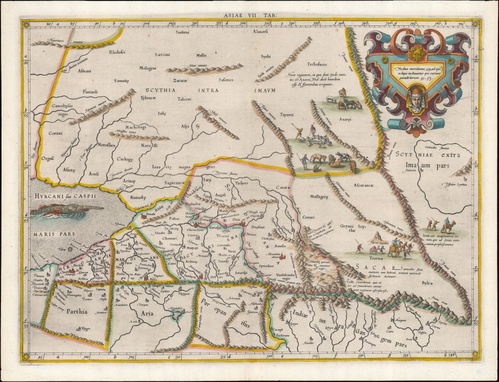
Asiae VII Tab.
1578 (undated) 13.75 x 18.25 in (34.925 x 46.355 cm) 1 : 10600000
1578 (undated) 13.75 x 18.25 in (34.925 x 46.355 cm) 1 : 10600000
Description
This is an edition of Gerard Mercator's superb Ptolemaic map of central Asia and the Silk Road. The seventh Asian map from Ptolemy's Geography, it depicts the lands in Central Asia, east of the Caspian Sea. These were occupied in the 1st and 2nd centuries CE by the Sogdiana, an ancient Iranian civilization that at different times included territory located in present-day Kazakhstan, Tajikistan, and Uzbekistan. To the north are shown the lands of the nomadic Scythians.
The Caspian Leg of the Silk Road
Centrally, the lands of the Sogdiana sit astride what we know now to be the Silk Road. At the eastern extent of the map is shown Turris Lapidea, the 'Stone Tower' (λίθινος πύργος in Greek) which marked the midpoint on the ancient Silk Road - the network of overland trade routes taken by caravans between Europe and Asia. The tower was the most important landmark on this route, where caravans stopped on their difficult and dangerous journeys to allow travelers to take on provisions, rest, and trade goods before continuing on.The Finest 16th Century Ptolemy
Printed editions of Ptolemy's Geography were issued as early as 1477. Ptolemy's methodology and data provided the foundation for all 16th century mapmaking. Mercator's 1578 edition was intended to be definitive. Mercator engraved the plates himself, correcting the maps to conform more closely to Ptolemy's original calculations than previous editions, which were based on Nicolas Germanus. Also, Mercator's impeccable engraving included the first uniform use of Italic text in an atlas (pioneered in his 1540 Literarum Latinarum). This gave his Ptolemaic maps unmatched legibility, allowing him to include more detail than previous editions. In addition, Mercator's engraving includes an elegant strapwork cartouche, depictions of cattle herders and Silk Road caravans, and a superb sea monster prowling the Caspian - which strongly resembles a colossal beluga sturgeon, a fish native to that body of water.Publication History and Census
This map was engraved by Gerard Mercator for inclusion in his 1578 edition of Ptolemy's Geography, Tabulae Geographicae Cl. Ptolemaei. The typography of this example identifies it as belonging to third, 1605 edition of the work. Seven examples of the separate map are cataloged in institutional collections.CartographerS
Gerard Mercator (March 5, 1512 - December 2, 1594) is a seminal figure in the history of cartography. Mercator was born near Antwerp as Gerard de Cremere in Rupelmonde. He studied Latin, mathematics, and religion in Rupelmonde before his Uncle, Gisbert, a priest, arranged for him to be sent to Hertogenbosch to study under the Brothers of the Common Life. There he was taught by the celebrated Dutch humanist Georgius Macropedius (Joris van Lanckvelt; April 1487 - July 1558). It was there that he changed him name, adapting the Latin term for 'Merchant', that is 'Mercator'. He went on to study at the University of Louvain. After some time, he left Louvain to travel extensively, but returned in 1534 to study mathematics under Gemma Frisius (1508 - 1555). He produced his first world map in 1538 - notable as being the first to represent North America stretching from the Arctic to the southern polar regions. This impressive work earned him the patronage of the Emperor Charles V, for whom along with Van der Heyden and Gemma Frisius, he constructed a terrestrial globe. He then produced an important 1541 globe - the first to offer rhumb lines. Despite growing fame and imperial patronage, Mercator was accused of heresy and in 1552. His accusations were partially due to his Protestant faith, and partly due to his travels, which aroused suspicion. After being released from prison with the support of the University of Louvain, he resumed his cartographic work. It was during this period that he became a close fried to English polymath John Dee (1527 - 1609), who arrived in Louvain in 1548, and with whom Mercator maintained a lifelong correspondence. In 1552, Mercator set himself up as a cartographer in Duisburg and began work on his revised edition of Ptolemy's Geographia. He also taught mathematics in Duisburg from 1559 to 1562. In 1564, he became the Court Cosmographer to Duke Wilhelm of Cleve. During this period, he began to perfect the novel projection for which he is best remembered. The 'Mercator Projection' was first used in 1569 for a massive world map on 18 sheets. On May 5, 1590 Mercator had a stroke which left him paralyzed on his left side. He slowly recovered but suffered frustration at his inability to continue making maps. By 1592, he recovered enough that he was able to work again but by that time he was losing his vision. He had a second stroke near the end of 1593, after which he briefly lost speech. He recovered some power of speech before a third stroke marked his end. Following Mercator's death his descendants, particularly his youngest son Rumold (1541 - December 31, 1599) completed many of his maps and in 1595, published his Atlas. Nonetheless, lacking their father's drive and genius, the firm but languished under heavy competition from Abraham Ortelius. It was not until Mercator's plates were purchased and republished (Mercator / Hondius) by Henricus Hondius II (1597 - 1651) and Jan Jansson (1588 - 1664) that his position as the preeminent cartographer of the age was re-established. More by this mapmaker...
Claudius Ptolemy (83 - 161 AD) is considered to be the father of cartography. A native of Alexandria living at the height of the Roman Empire, Ptolemy was renowned as a student of Astronomy and Geography. His work as an astronomer, as published in his Almagest, held considerable influence over western thought until Isaac Newton. His cartographic influence remains to this day. Ptolemy was the first to introduce projection techniques and to publish an atlas, the Geographiae. Ptolemy based his geographical and historical information on the "Geographiae" of Strabo, the cartographic materials assembled by Marinus of Tyre, and contemporary accounts provided by the many traders and navigators passing through Alexandria. Ptolemy's Geographiae was a groundbreaking achievement far in advance of any known pre-existent cartography, not for any accuracy in its data, but in his method. His projection of a conic portion of the globe on a grid, and his meticulous tabulation of the known cities and geographical features of his world, allowed scholars for the first time to produce a mathematical model of the world's surface. In this, Ptolemy's work provided the foundation for all mapmaking to follow. His errors in the estimation of the size of the globe (more than twenty percent too small) resulted in Columbus's fateful expedition to India in 1492.
Ptolemy's text was lost to Western Europe in the middle ages, but survived in the Arab world and was passed along to the Greek world. Although the original text almost certainly did not include maps, the instructions contained in the text of Ptolemy's Geographiae allowed the execution of such maps. When vellum and paper books became available, manuscript examples of Ptolemy began to include maps. The earliest known manuscript Geographias survive from the fourteenth century; of Ptolemies that have come down to us today are based upon the manuscript editions produced in the mid 15th century by Donnus Nicolaus Germanus, who provided the basis for all but one of the printed fifteenth century editions of the work. Learn More...
Source
Mercator, G. / Ptolemy, C., Geographiae Libri Octo Graeco-Latini, (Amsterdam: Hondius) 1605.
Condition
Excellent. Fine hand color.
References
OCLC 500591339. Rumsey 10991.203 (1584). Van der Krogt, P., Koeman's Atlantes Neerlandici, 0927:1.1