This item has been sold, but you can get on the Waitlist to be notified if another example becomes available, or purchase a digital scan.
1936 F. M. S. Survey Map of Singapore
Singapore-fms-1936$600.00

Title
Singapore.
1936 (dated) 20 x 28 in (50.8 x 71.12 cm) 1 : 63360
1936 (dated) 20 x 28 in (50.8 x 71.12 cm) 1 : 63360
Description
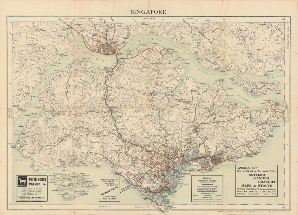
A delightful 1936 map of Singapore produced by the Survey Department of the Federated States of Malaya (FMS) that appeared in Willis's Singapore Guide. It depicts the colony in the years just prior to the World War II (1939 - 1945), while the advertisements at bottom give a sense of the preoccupations of the colony's population.
Singapore emerged as the premier trade entrepot in the Malacca Straits in the 19th century and in subsequent decades its trade-based economy boomed. The British expatriate population composed of government officials, soldiers, sailors, and businessmen, with their families, lived comfortably, as the advertisements at bottom indicate. Sites noted on the map include swim clubs, a zoo, and an amusement park. Curiously, the advertisement for the California Sandwich Shoppe stresses that it is 'under European management,' most likely reflecting condescension towards non-European (i.e. Chinese, Indian, or Malay) managed businesses.
Although not displayed here, in 1936 the British were in the course of building a massive naval base at Sembawang at the northernmost point of the island, the linchpin of the empire's Far Eastern defense plan in the event of a war with Japan. Equally impressive naval batteries protected the approaches to the base at points along the coast. Winston Churchill memorably dubbed Singapore the 'Gibraltar of the East.' British defensive plans envisaged a Japanese attack coming from the sea, but in December 1941 - January 1942, Japanese forces instead made a rapid advance down the Malay Peninsula and prepared an attack on Singapore from across the Johor Strait. Using scorched earth tactics to slow the Japanese, the British blew up the causeway to Johor, but this only temporarily halted the Japanese advance.
The British defense of Singapore was disastrous and led to the island being surrendered after only a week of fighting in February 1942. It was one of the most shocking and embarrassing defeats in the history of the British Empire. Ironically, the British commander Arthur Percival had written a report in 1937 predicting that Singapore would be particularly susceptible to an invasion coming from Malaya.
A Closer Look
The dense urban core is immediately clear, with surrounding areas dedicated to 'estates' (public housing), settlements, villages, plantations, cemeteries, water supply, and other uses. Major roads are clearly indicated with dark orange lines and the island's sole railway line, connecting it to Johor across the causeway, is shown here with an alternating black and white line. Numbers written in black throughout refer to elevation.Singapore emerged as the premier trade entrepot in the Malacca Straits in the 19th century and in subsequent decades its trade-based economy boomed. The British expatriate population composed of government officials, soldiers, sailors, and businessmen, with their families, lived comfortably, as the advertisements at bottom indicate. Sites noted on the map include swim clubs, a zoo, and an amusement park. Curiously, the advertisement for the California Sandwich Shoppe stresses that it is 'under European management,' most likely reflecting condescension towards non-European (i.e. Chinese, Indian, or Malay) managed businesses.
Although not displayed here, in 1936 the British were in the course of building a massive naval base at Sembawang at the northernmost point of the island, the linchpin of the empire's Far Eastern defense plan in the event of a war with Japan. Equally impressive naval batteries protected the approaches to the base at points along the coast. Winston Churchill memorably dubbed Singapore the 'Gibraltar of the East.' British defensive plans envisaged a Japanese attack coming from the sea, but in December 1941 - January 1942, Japanese forces instead made a rapid advance down the Malay Peninsula and prepared an attack on Singapore from across the Johor Strait. Using scorched earth tactics to slow the Japanese, the British blew up the causeway to Johor, but this only temporarily halted the Japanese advance.
The British defense of Singapore was disastrous and led to the island being surrendered after only a week of fighting in February 1942. It was one of the most shocking and embarrassing defeats in the history of the British Empire. Ironically, the British commander Arthur Percival had written a report in 1937 predicting that Singapore would be particularly susceptible to an invasion coming from Malaya.
Publication History and Census
This map appeared in Willis's Singapore Guide in 1936 and is based on an official map by the Survey Department of the Federated States of Malaya. It is independently cataloged in the holdings of eleven institutions worldwide, including the Library of Congress and the University of Illinois at Urbana Champaign. Willis's Singapore Guide (OCLC 652166097, 11612342, 42825087) is held by as many as eighteen institutions, though ambiguity around the date and title suggest multiple editions.Cartographer
Federated Malay States Survey (1922 - 1945), better known as the F.M.S. Survey Department, was established in the early 20th century to produce detailed surveys of British Malaya and the Straits Settlements. The survey department had offices in most major Malayan ports, including Singapore, Kuala Lumpur, Penang (Georgetown), and Malacca. They were the first official survey organization to publish detailed scientifically produced maps of the region. More by this mapmaker...
Condition
Good. Wear along fold original lines, leading to marginal tears and areas of loss at fold intersections (repaired on verso).
References
OCLC 904322186.