This item has been sold, but you can get on the Waitlist to be notified if another example becomes available, or purchase a digital scan.
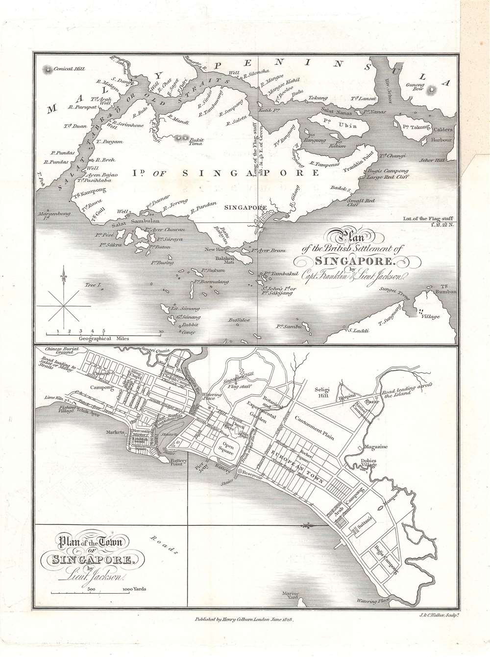
1828 Jackson / Crawfurd Map of Singapore - first map of Singapore!
Singapore-jackson-1828-3$1,750.00

Title
Plan of the Town of Singapore by Lieut. Jackson. / Plan of the British Settlement of Singapore by Capt. Franklin and Lieut. Jackson.
1828 (dated) 9 x 6.75 in (22.86 x 17.145 cm) 1 : 20500
1828 (dated) 9 x 6.75 in (22.86 x 17.145 cm) 1 : 20500
Description
Known as the Jackson Plan or Raffles Plan, this is the first published map of Singapore. Published in 1828, the map was drawn by Lieutenant Philip Jackson at the request of the founder of modern Singapore, Sir Stamford Raffles (1781 - 1826). It is divided into two sections, a map of the island of Singapore at top, and a close-up plan of the town of Singapore at bottom, oriented towards the west. The city plan presents an idealized version of Singapore following the Raffles vision and, while not fully implemented, was influential in the early development of the colony.
Historical Context
Stamford Raffles founded Singapore as a British colony in 1819, looking for a site to challenge the Dutch, who had a colony at Melaka from which they threatened to dominate the Straits of Malacca. Finding a sparsely populated but strategically located island at the end of the Malay Peninsula with a natural deep harbor and ready supply of fresh water, Raffles intervened in a factional struggle in the Sultanate of Johor, which nominally controlled the island, supporting one faction in exchange for being granted the island. Having engineered the handover of the island to British sovereignty, Raffles set it up as a free port and then promptly returned to Bencoolen, leaving William Farquhar (1774 - 1839) to manage the colony. From the beginning, Singapore witnessed rapid growth and high volume as a port. With limited funds, Farquhar could not fully control the urban development of Singapore town and allowed for haphazard organic growth. When Raffles returned in October of 1822, he was displeased by the chaotic development and commissioned Lieutenant Philip Jackson, who himself had just arrived in Singapore, to create a new development plan outlining his ambitious urban vision.The Raffles Vision
Raffles' plan for Singapore called for structured, centrally planned development with racial and social segregation. He created a Town Committee to lay out Singapore along six points:- The area between the Old Lines (a ruined city wall roughly where Stamford Road now lies) and the Singapore River including a space up to 200 yards east of the Old Lines (i.e. up to where Bras Basah Road is now located) would be reserved as a cantonment for government use. A famous colonial-style hotel nearby that was built in the 1880s now bears Raffles name, due to its having been used by the Raffles Institution, the oldest educational institution in Singapore, for many years.
- The European area would be located to the east of the cantonment (the government area) as far as the ground that belonged to the Sultan. The area of the cantonment facing the sea and area southwest of the river between Circular Road and Telok Ayer Bay would be used for commerce.
- Raffles (correctly) expected that the Chinese would eventually constitute the largest community, and so reserved a large area for them southwest of the Singapore River. Indians would be settled further up the river.
- The Bugis (who had already settled in Kampong Glam) and Arabs were to be allocated areas next to the Sultan's ground. Raffles (mistakenly) did not believe that there would be significant Malay settlers, but thought they may settle the upper banks of the river.
- The sea front and port was to be reserved for public use.
- In addition to allocating land, Raffles also determined a location for the Telok Ayer Market, stipulated that burial grounds be placed far from the town, and required urban uniformity.
Publication History and Census
The map was drawn in late 1822 or early 1823, but was not printed until John Crawfurd included it in the 1828 publication of his Journal of an Embassy from the Governor-General of India to the courts of Siam and Cochin-China: exhibiting a view of the actual state of those kingdoms. The plan was engraved in London by the firm of J. and C. Walker and was published by Henry Colburn. The map was included in all editions of Crawfurd's work but is rarely found separately and is scarce to the market. The OCLC cites three separate examples at the British Library, the National Library Board of Singapore, and the Bibliothèque nationale de France.CartographerS
Philip Jackson (September 24, 1802 - 1879) was a British naval officer, surveyor, and engineer active in the early settlement and planning of Singapore. Jackson was born in Durham and joined the East India Company army at 16. He traveled to India with the Bengal Artillery Regiment and was subsequently posted to Singapore in January of 1822. Leveraging Jacksons experience as a surveyor and engineer, Singapore founder Stamford Raffles appointed him Assistant Engineer on October 29 of 1922. Jackson was tasked with realizing Raffles vision for the design and layout of Singapore and is credited with the first map of Singapore, published in 1828. Jackson was appointed surveyor of Singapore's public lands in February of 1826. More by this mapmaker...
John Walker (1787 - April 19, 1873) was a British map seller, engraver, lithographer, hydrographer, geographer, draughtsman, and publisher active in London during the 19th century. Walker published both nautical charts and geographical maps. His nautical work is particularly distinguished as he was an official hydrographer for the British East India Company, a position, incidentally, also held by his father of the same name. Walker's maps, mostly published after 1827, were primarily produced with his brothers Charles Walker and Alexander Walker under the imprint J. and C. Walker. Among their joint projects are more than 200 maps for the influential Society for the Diffusion of Useful Knowledge Atlas (SDUK). In addition they published numerous charts for James Horsburgh and the British Admiralty Hydrographic Office, including Belcher's important map of Hong Kong and Carless' exploratory map of Karachi. The J. and C. Walker firm continued to publish after both Walkers died in the 1870s. Learn More...
Henry Colburn (1784 - August 16, 1855) was a British publisher. Colburn started off in the publishing profession in the Albemarle Street shop of William Earle, a bookseller in London. His next move was to become an assistant at a circulating library on Conduit Street called Morgan's Library, which he took over in 1816. Eventually he signed this business over to Messrs. Saunders and Otley and opened his own publishing firm. He gained initial success with the roman à clef novel Glenavron by Lady Caroline Lamb and which was published in 1816. It went through four editions and sold well. Colburn later expanded on the success of Glenavron and published a series of so-called 'Silver Fork Novels', a series of books that afforded readers the thrill of peering into the lives of rich and aristocratic families. Colburn also started several periodicals, including the New Monthly Magazine, the Literary Gazette, the earliest weekly newspaper dedicated to literature, science, and the arts. Colburn married twice. His second marriage was to Eliza Anne, who survived him. Learn More...
Source
Crawfurd, J., Journal of an Embassy from the Governor-General of India to the courts of Siam and Cochin-China: exhibiting a view of the actual state of those kingdoms, (London: H. Colburn), 1828.
Condition
Very good. Sporadic toning and offsetting, with area of discoloration at top-right margin.
References
OCLC 557484724, 495091336. Bonny Tan, 'Raffles Town Plan (Jackson Plan)', Singapore Infopedia. H. F. Pearson (July 1969). 'Lt. Jackson's Plan of Singapore', Journal of the Malaysian Branch of the Royal Asiatic Society, 42 (1 (215) Singapore 150th Anniversary Commemorative Issue): 161 - 165.