This item has been sold, but you can get on the Waitlist to be notified if another example becomes available, or purchase a digital scan.
1942 Japanese Pictorial Map of Singapore Island
Singapore-tokyodaily-1942$325.00

Title
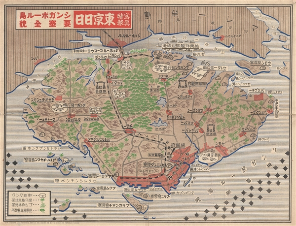
写真特報, 東京日日, シンガポール島, 要塞全貌 / Tokyo Daily Photo Dispatch - Singapore Island Fortress, Full Picture / Shashin tokuhō, Tōkyō nichinichi, shingapōru shima, yōsai zenbō.
1942 (dated) 20 x 26 in (50.8 x 66.04 cm) 1 : 82000
1942 (dated) 20 x 26 in (50.8 x 66.04 cm) 1 : 82000
Description
A remarkable 1942 World War II (WWII) era map of Singapore Island issued by the Japanese newspaper Tokyo Nichi Nichi Shimbun. The map details the island of Singapore with a focus on resources and fortifications. Airfields, naval bases, artillery batteries, above and underground oil supplies, and electrical substations are identified and rendered pictorially. In additional the map identifies various types of plant life from Banana plantations to tropical jungle. In the surrounding waters minefields are shown. All text is in Japanese. A rare discovery.
Cartographer
The Tokyo Nichi Nichi Shimbun (東京日日新聞; Tōkyō Nichi Nichi Shinbun), whose names translates literally as the Tokyo Daily News was a newspaper printed in Tokyo, Japan from 1872 to 1943. It began daily distribution to individual addresses in 1875, making it the world's first daily newspaper delivery service. In 1911, the paper merged with Osaka Mainichi Shimbun (大阪毎日新聞, Osaka Daily News) to form the Mainichi Shimbun (毎日新聞, Daily News) company. The two newspapers continued to print independently until 1943. More by this mapmaker...
Condition
Very good. Original fold lines exhibit some wear. Professionally backed with archival kozo tissue for stabilitiy.