1927 Admiralty Nautical Chart / Map of Singapore Strait East
SingaporeStraitEast-admiralty-1927$950.00


Title
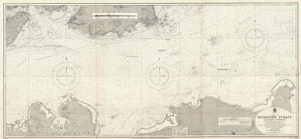
China Sea Singapore Strait Eastern Portion.
1927 (dated) 27.25 x 58.5 in (69.215 x 148.59 cm) 1 : 50000
1927 (dated) 27.25 x 58.5 in (69.215 x 148.59 cm) 1 : 50000
Description
This is a first edition 1927 British Admiralty nautical chart or maritime map of the eastern portion of the Singapore Strait. The map was issued during the Interwar Period when British naval hegemony was waning and the 'Singapore Strategy' attempted to turn the island colony into a 'Gibraltar of the East.'
The British determined to establish a 'Gibraltar of the East,' zoning in on Singapore for its exceptional strategic position. Starting work in 1919, the British began a series of extensive improvements to the port at an expense of some 500,000 GBP. Completed over the subsequent twenty years, Singapore was outfitted with the largest dry dock in the world, the third largest wet dock, and enough fuel tanks to support the entire Royal Navy for six months. The island's defenses also included an enormous Royal Air Force base and mounted 15-inch stationary guns. Despite what appeared to be a highly defensible position, in 1942, when hostilities finally broke out between the British Empire and Imperial Japan, Singapore fell to Japanese invaders after just fifteen days of fighting, an event described by British Prime Minister Winston Churchill as the 'worst disaster and largest capitulation in British history.'
A Closer Look
Coverage embraces from Singapore Island to Pulo Bintan (Pulau Bintan) and from Johore and the Johore Strait to Pulo Batam (Pulau Batam). Depth soundings, measured in fathoms, populate the map. Various reefs, shoals, and other nautical hazards appear as well, along with some coastal landmarks. Yellow dots mark the few lights present in the region. A profile view of the coastline between Carter Shoal and South Ledge appears along the upper border in Johore. A table of tidal information is situated in the lower right corner.The Singapore Strategy
As this map was being printed, Singapore became central to the Singapore Strategy, a naval defense policy instituted by the British Empire between 1919 and 1941. Following World War I (1914 - 1918), the Royal Navy faced challenges to its long-established supremacy by the rising naval forces of the United States and Imperial Japan. While the growing U.S. Navy, a strong ally, was not a serious cause of concern, it quickly became apparent that the Imperial Japanese naval buildup would clash with British interests in the Far East.The British determined to establish a 'Gibraltar of the East,' zoning in on Singapore for its exceptional strategic position. Starting work in 1919, the British began a series of extensive improvements to the port at an expense of some 500,000 GBP. Completed over the subsequent twenty years, Singapore was outfitted with the largest dry dock in the world, the third largest wet dock, and enough fuel tanks to support the entire Royal Navy for six months. The island's defenses also included an enormous Royal Air Force base and mounted 15-inch stationary guns. Despite what appeared to be a highly defensible position, in 1942, when hostilities finally broke out between the British Empire and Imperial Japan, Singapore fell to Japanese invaders after just fifteen days of fighting, an event described by British Prime Minister Winston Churchill as the 'worst disaster and largest capitulation in British history.'
Publication History and Census
This chart was published by the Admiralty in 1927 as Admiralty Chart 3834. We note a single cataloged example, which is part of the collection at the British Library.Cartographer
The British Admiralty Office (1795 - Present) or the United Kingdom Hydrographic Office refers to the Branch of the English government that is responsible for the command of the British Navy. In 1795 King George III created the United Kingdom Hydrographic Office, known in short as the U.K.H.O., to provide top notch nautical charts to the vast Royal Navy. Prior the founding of the Admiralty the surveying and creation of nautical charts was primarily a commercial venture wherein the cartographer himself, more of than not, actually financed the printing of his own material. The great navigator Cook himself is known to have scrambled for funds to publish his own seminal charts - the most important and advanced of the period. The system of privately funded nautical mapping and publishing left vast portions of the world uncharted and many excellent charts unpublished. King George III, responding significant loss in trade revenue related to shipwrecks and delay due to poor charts, recognized the need for an institutionalized government sponsored cartographic agency - the Admiralty. The first head of the Admiralty, a position known as Hydrographer, was the important cartographer Alexander Dalrymple. Dalrymple started by organizing and cataloging obtainable charts before initiating the laborious process of updating them and filling in the blanks. The first official Admiralty Chart appeared in 1800 and detailed Quiberon Bay in Brittany. By 1808 the position of Hydrographer fell to Captain Thomas Hurd. Hurd advocated the sale of Admiralty charts to the general public and, by the time he retired in 1829, had issued and published some 736 charts. Stewardship of the organization then passed to Rear Admiral Sir Francis Beaufort. It was under Beaufort's administration that the Admiralty truly developed as a "chart making" as opposed to a "chart cataloging" institution. Beaufort held his post from 1829 to 1854. In his 25 years at the Admiralty Beaufort created nearly 1500 new charts and sponsored countless surveying and scientific expeditions - including the 1831 to 1836 voyage of the H.M.S. Beagle. By 1855 the Admiralty's chart catalog listed some 1,981 charts. More by this mapmaker...
Condition
Very good. Even overall toning. Light wear along original fold lines.
References
OCLC 557485932.