This item has been sold, but you can get on the Waitlist to be notified if another example becomes available, or purchase a digital scan.
1859 U.S. Coast Survey Chart or Map of Coastal Georgia and South Carolina
SketchESectionV-uscs-1857$112.50

Title
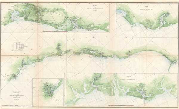
Sketch E Showing the Progress of the Survey in Section No. V from 1847 to 1857.
1857 (dated) 22.25 x 36 in (56.515 x 91.44 cm) 1 : 600000
1857 (dated) 22.25 x 36 in (56.515 x 91.44 cm) 1 : 600000
Description
This is an appealing 1860 U.S. Coast Survey chart or map of the Georgia and South Carolina coastline with four sub sketches. The large central map depicts from Cumberland Island in Florida to Cape Fear in North Carolina. Focusing on the bays and mouths of rivers, triangulation surveys are provided for several locations along the coast. St. Mary's and Fernandina, Georgia and Charleston, South Carolina are depicted. The first sub sketch, on the upper left, provides a detailed survey from St. Helena Sound to Bull's Island, South Carolina. The second sub sketch, on the upper right, details the South Carolina coast from Bull's Bay to Winyah Bay. The third sub sketch presents a detailed look at the coast from Ossabaw Island to Cumberland Island. A fourth sub sketch, on the lower left, details the St. Mary's River from St. Mary's to its mouth near Cumberland Island.
This map was compiled under the direction of A. D. Bache, Superintendent of the Survey of the Coast of the United States and one of the most influential American cartographers of the 19th century, and issued in the 1860 edition of the Superintendent's Report.
This map was compiled under the direction of A. D. Bache, Superintendent of the Survey of the Coast of the United States and one of the most influential American cartographers of the 19th century, and issued in the 1860 edition of the Superintendent's Report.
Cartographer
The Office of the Coast Survey (later the U.S. Geodetic Survey) (1807 - present), founded in 1807 by President Thomas Jefferson and Secretary of Commerce Albert Gallatin, is the oldest scientific organization in the U.S. Federal Government. Jefferson created the "Survey of the Coast," as it was then called, in response to a need for accurate navigational charts of the new nation's coasts and harbors. The first superintendent of the Coast Survey was Swiss immigrant and West Point mathematics professor Ferdinand Hassler. Under the direction of Hassler, from 1816 to 1843, the ideological and scientific foundations for the Coast Survey were established. Hassler, and the Coast Survey under him developed a reputation for uncompromising dedication to the principles of accuracy and excellence. Hassler lead the Coast Survey until his death in 1843, at which time Alexander Dallas Bache, a great-grandson of Benjamin Franklin, took the helm. Under the leadership A. D. Bache, the Coast Survey did most of its most important work. During his Superintendence, from 1843 to 1865, Bache was steadfast advocate of American science and navigation and in fact founded the American Academy of Sciences. Bache was succeeded by Benjamin Pierce who ran the Survey from 1867 to 1874. Pierce was in turn succeeded by Carlile Pollock Patterson who was Superintendent from 1874 to 1881. In 1878, under Patterson's superintendence, the U.S. Coast Survey was reorganized as the U.S. Coast and Geodetic Survey (C & GS or USGS) to accommodate topographic as well as nautical surveys. Today the Coast Survey is part of the National Oceanic and Atmospheric Administration or NOAA. More by this mapmaker...
Source
Bache, A. D., Report of the Superintendent of the United States Coast Survey, (Washington) 1857.
Condition
Very good. Backed on archival tissue for stability.