This item has been sold, but you can get on the Waitlist to be notified if another example becomes available, or purchase a digital scan.
1902 Ferguson Map of Suzhou (Soochow), China and Environs
Soochow-ferguson-1902$750.00

Title
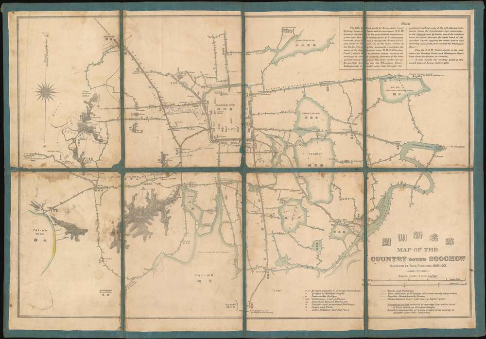
蘇境新測圖. Map of the Country round Soochow.
1902 (undated) 17.5 x 25.25 in (44.45 x 64.135 cm) 1 : 63360
1902 (undated) 17.5 x 25.25 in (44.45 x 64.135 cm) 1 : 63360
Description
This is a 1901 Thomas Ferguson map of the garden city of Suzhou (Soochow), China and environs. Focusing on Suzhou's broad network of canals, the map encompasses the region from Lake Tai (Tai-Hu) to 'Soochow Creek' and from Yangcheng Lake (Yang-Sêng-Si-Wu) to the Grand Canal and 'Ng-Kong. The map serves the dual purpose of expanding military intelligence in the Yangtze Valley, and highlighting the usefulness of Ferguson's invention, the 'hodograph.' Ferguson used the hodograph to 'automatically' survey the canals, creeks, rivers, and other waterways in the region and then converted that data into his map. Arrows indicate the direction of some of the canals, which likely means that others supported two-way traffic. Suzhou's canals have always played a critical role in the local economy and even today are a major attraction for tourism. The Suzhou section of The Grand Canal passes through ten city gates and is traversed by more than twenty stone bridges.
The Map's Details
Suzhou, labeled here as Soochow City, is situated just above center and is surrounded by canals. Pagodas and Western Christian missions are labeled within Suzhou, and the Japanese concession and foreign settlements are labeled outside the city proper. The city's railway station, which was completed in 1906, is marked here in manuscript just above the Parade Ground on the opposite side of the canal. A key, situated along the bottom border in the lower right quadrant, explains the various notations used. Four different symbols are used to differentiate between three categories of bridges, which are: 'bridges passable to average Houseboat' (how many tourists traveled in the region and likely one of Ferguson's main audiences), 'bridges of doubtful height', and 'impossible bridges'. The small squares dotting the banks of the waterways mark houses, farms, and other manmade structures, while temples and prominent buildings merit their own symbol. Likin stations, where taxes were collected on imports and items being shipped from one place to another, are also identified. Other buildings are labeled in both Romanized Chinese and Chinese characters. Some comments, such as 'flower nurseries', old imperial roads, and ferries are only labeled in English.The Hodograph
Europeans traveling in Asia were often dumfounded by the wide-scale use and management of complex canal systems for commercial traffic. The canals presented a natural surveying problem. Ferguson writes in his book Automatic surveying instruments and their practical uses on land and water that he devised the hodograph 'with the object of obtaining…detailed route surveys' of the myriad canals, rivers, creeks, and streams of the Kiangsu Province. Before he created this device, surveys of this kind would have been done in pairs, at least, and taken exponentially more time than the forty excursions undertaken by Ferguson on weekends and holidays to create the present map and Map of the Waterways near Shanghai. Ferguson does admit that the accuracy of his device isn't perfect, which he states is due to the many steps that must be undertaken to convert the results of a hodograph survey into a paper map. However, he goes on to say that, in an effort to reduce likely errors, every section of one of his maps is traversed twice, in opposite directions, and the results of the surveys are then compared and adjusted where necessary.The Grand Canal
The Grand Canal, prominently illustrated here and highlighted by red manuscript notation, bears the distinction of being both the longest and the oldest canal in the world and is a UNESCO World Heritage Site. It links the Yellow River with the Yangtze River and the oldest parts of the canal date back to the 5th century BC, but were not connected until the Sui dynasty, which lasted from 581 until 618 AD.Taiping Rebellion
Just to the left of 'Soochow City' is an area set off by dashed lines and labeled simply as 'Rubble Country'. A caption, however, informs the viewer that this area was the 'site of [an] old suburb devastated by Taipings'. The Taiping Rebellion, which lasted from 1850 until 1864, was a civil war waged between the Manchu-led Qing dynasty and the Hakka-led Taiping Heavenly Kingdom. The Taipings, led by the self-proclaimed brother of Jesus Christ Hong Xiuquan, sought the overthrow of the Manchus and the religious conversion of the Chinese people to their syncretic version of Christianity, as well as other reforms that would completely remake Chinese society. The Taipings founded the Taiping Heavenly Kingdom in Nanjing (then Tianjing) and eventually gained control of a population base that numbered close to 30 million. The rebellion reached all but one of China's provinces and was fought primarily across the mid and lower Yangtze Valley. It ranks as history's bloodiest civil war, and the longest war of the 19th century, with those killed estimated anywhere between 10 and 30 million.Publication History and Census
This map was created by Thomas Ferguson and published in 1902 in Shanghai by Kelly and Walsh Ltd. Five examples are catalogued in the OCLC and are part of the institutional collections at Trinity College, Cornell University, the Library University of Amsterdam, the Bibliothèque nationale de France, and the University Library of Marburg, Germany. It is rare on the private market.Cartographer
Thomas Tapley Helenus Ferguson (January 18, 1871 - June 20, 1946) was a Dutch surveyor and inventor. Born in Aruba, Ferguson arrived in China in the late 1800s and lived in Shanghai. He created two known maps, one entitled Map of the Waterways Near Shanghai and the other Map of the Country Round Soochow, for which he used a device of his own invention, which he called a Hodograph. Ferguson published a book in 1904 entitled Automatic Surveying Instruments and their Practical Uses on Land and Water in which he introduced his Hodograph (a device used for 'self-registering of courses and distances on water'), Cyclograph ('an automatic route-tracer for vehicles'), and Pedograph (an automatic route-tracer for pedestrians'). Ferguson applied for a patent in the United States in 1902, but it is unclear if he ever tried to patent his other two inventions. Records show that Ferguson was married four times and fathered four children. Ferguson died on June 20, 1946 at Exmouth in the United Kingdom. More by this mapmaker...
Condition
Average. This is a historical artifact exhibiting wear associated with use. Laid down on unusual blue linen. Old linen brittle and reinforced in places. Replacement of linene at some fold intersections.
References
OCLC 928177018.