This item has been sold, but you can get on the Waitlist to be notified if another example becomes available.
1940 Denoyer-Geppert Wall Map of Demographics and Immigration in the U.S.
SourcesImmigrants-hart-1940$150.00

Title
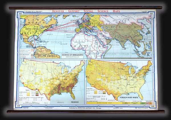
Sources of Immigrants. Negroes. Foreign Born White.
1940 (undated) 30.5 x 43.5 in (77.47 x 110.49 cm) 1 : 25344000
1940 (undated) 30.5 x 43.5 in (77.47 x 110.49 cm) 1 : 25344000
Description
This is a c. 1940s Albert Bushnell Hart and Denoyer-Geppert Company wall map of the world. The map depicts from North America to the Pacific Ocean, Japan, and Indonesia (labeled the Netherlands, Indies) and from the Arctic Circle to just past the Equator. Occupying the top half of the wall map, the world map illustrates the quota status of the nations of the world. The quota system was established by the Emergency Quota Act of 1921 and made even more restrictive by the Immigration Act of 1924. This Act stated that only 2% of the number of people from a given country who were in the United States as of the 1890 census could immigrate to the United States. It also effectively banned immigration from Japan, and immigration from China had already been ended by law in 1882.There were two non-quota areas, which were North and South America. Numerous countries and several cities are labeled the world over.
Two inset maps make up the bottom half of this wall map. The first, on the left, depicts the percentage of African-Americans in any given region, from less than 1% to over 50%. Populations percentages are also depicted for certain cities across the country. A decidedly offensive term is used for the title of this inset map. The other inset map, on the left, illustrates the percentage of foreign born whites throughout the country, from less than 1% to 50-55%. A bar graphic is included along the bottom border of this inset map, illustrating what percentage each demographic represents in the total population of the United States. Again, decidedly offensive terms are employed as labels here.
This map was created by Albert Bushnell Hart with L. Philip Denoyer serving as geographer. The map was compiled and drawn by R. Baxter Blair and published by the Denoyer-Geppert Company of Chicago. It is number A41 in the Denoyer-Geppert Social Science map series. We have dated this map as c. 1940s due to the paper it is printed on. Several different editions of this map were printed, which allows for the possibility that this particular example could date from an earlier or later year.
CartographerS
The Denoyer-Geppert Company (1916 - 1984) was a Chicago-based publishing firm that dealt in maps, atlases, and spherical cartography (globes). For 68 years, the company played a critical role in the education of the world’s students. Founded in 1916 by Otto E. Geppert (the salesman) and L. Philip Denoyer (the cartographer/editor). Denier was born in Milwaukee in 1875 and was a high school principal by the age of 32. He was also completing graduate work at the University of Chicago at the same time. He was appointed the first Professor of Geology and Geography at the State Teacher’s College - La Crosse (University of Wisconsin) in 1909. Legend has it that Denoyer met Geppert while teaching one of his classes, when the latter came up from Chicago to sit in on one. Geppert was working as a salesman for A.J. Nystrom and Company, which today self-identifies as ‘the United States’ older publisher of wall maps and globes for classroom use.’ Geppert was there to sell Denoyer on joining the team at Nostrum, believing that his expertise could benefit the company. Three years later they founded the Denoyer-Geppert Company, and within six years had moved from a 500 square foot space into the 50,000 square foot Swedish-American Telephone Building. By 1922, their catalogue consisted of ‘1,200 maps, charts, globes, and associate aids in teaching geography and history and 800 brilliantly illuminated biological charts and anatomical models.’ In 1967, Denoyer-Geppert was contracted by NASA to build the first official and accurate ‘lunar globe’, based on information gathered by Apollo 10 astronauts. The company made 200 of these globes, the first of which was presented by the astronauts of Apollo 10 to President Nixon. Rand McNally, one of their major competitors, bought out their inventory of maps and globes in 1984. Denoyer-Geppert left the Swedish-American Telephone Building and reinvented the company as the Denoyer-Geppert Science Company, which specializes in anatomical models for classrooms. The Swedish-American Telephone Company has been named a historic landmark and was remodeled into loft apartments. More by this mapmaker...
Albert Bushnell Hart (July 1, 1854 - July 16, 1943), a member of the Harvard University faculty for 43 years, was an American historian, writer, and editor. Hart was one of the first generation of professionally trained historians in the United States and a prolific author. He graduated from Harvard in 1880 and went on to study in Paris, Berlin, and Freiburg. He received his doctorate at Freiburg in 1883. He returned to Harvard that year as the instructor of the American history course offered at the time and retired in 1926. Learn More...
Condition
Very good. Backed on linen. Attached to original rollers. Measurment is for the map itself. Since the map is attached to rods, they add an another 2 inches in height and 3.5 inches in width.