This item has been sold, but you can get on the Waitlist to be notified if another example becomes available, or purchase a digital scan.
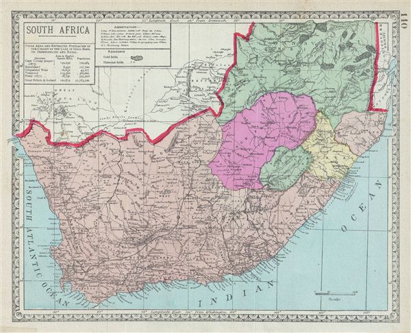
1887 Tunison Map of South Africa
SouthAfrica-tunison-1887$50.00

Title
South Africa.
1887 (undated) 10.5 x 13 in (26.67 x 33.02 cm)
1887 (undated) 10.5 x 13 in (26.67 x 33.02 cm)
Description
This is a beautiful example of the 1882 Tunison map of South Africa. It covers South Africa including Basutoland (Kingdom of Lesotho). Various Gold and Diamond Fields are identified. After the discovery of diamonds in 1867 and gold in 1884, colonial powers and the indigenous population struggled to control these resources. This led to the First Boer War in 1880 in which the British were defeated. The British were however victorious in the Second Boer War. Map is highly detailed and color coded according to political and regional boundaries. Various towns, cities, rivers, deserts, mountains and other topographical details are noted. Published as plate no. 140 in Tunison's Peerless Universal Atlas.
Cartographer
Henry Tunison (fl. c. 1886 – 1909) was a late 19th century American map publisher and businessman based in Illinois. Tunison published the Peerless Universal Atlas in various editions from 1886 to 1909. Unlike his competitors, the Rand McNally Company and George F. Cram, who printed low quality atlases using printed color, Tunison utilized old world publishing techniques and distinctively vivid hand color to drive the sales of his popular atlas. Because of this, Tunison’s maps, though late of period, remain desirable among collectors. Little is certain regarding Tunison’s early life; however, it may be one Henry Tunison whose family immigrated to Illinois from New Jersey in 1838. More by this mapmaker...
Source
Tunison, H., Tunison's Peerless Universal Atlas (Jacksonville, Illinois) 1887.
Condition
Very good. Portion of map on verso.