
This item below is out of stock, but another example (left) is available. To view the available item, click "Details."
Details
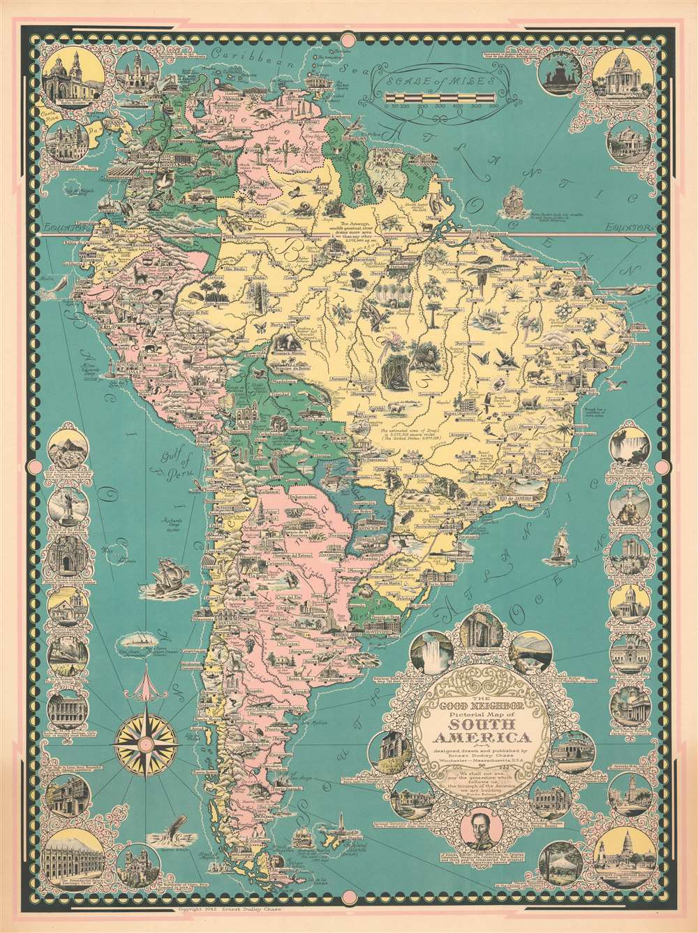
1942 Ernest Dudley Chase Pictorial Map of South America
$400.00
1942 Ernest Dudley Chase Pictorial Map of South America
SouthAmerica-ernestdudleychase-1942$125.00

Title
The Good Neighbor Pictorial Map of South America.
1942 (dated) 28 x 21.25 in (71.12 x 53.975 cm) 1 : 11500000
1942 (dated) 28 x 21.25 in (71.12 x 53.975 cm) 1 : 11500000
Description
This is a 1942 Ernest Dudley Chase pictorial map of South America. The map depicts the continent from the Pacific Ocean to the Atlantic Ocean and from Costa Rica to Cape Horn. Incredibly detailed and beautifully illustrated, Chase highlights the wide array of flora and fauna that call South America home alongside its most spectacular natural and man-made sites. Illustrations of South American animals, including the condor, anteater, sloth, macaw, toucan, iguana, and chinchilla, fill the continent. The continent's other natural riches, such as Brazil's diamonds and emeralds, the rubber found in the Amazon, oil, cacao, and tea are also promoted. Cities and towns are labeled throughout, including Sao Paulo, Caracas, Bogota, Quito, La Paz, Lima, Montevideo, Buenos Aires, and Santiago. Each of these cities, along with many others, are also identified by illustrations of famous buildings, or, in the case of Rio de Janeiro, Copacabana Beach. Circular vignettes appear along all four borders and highlight famous buildings from across the continent, the majority of which are churches. Others illustrate world famous sites, such as Machu Picchu, Iguazu Falls, and the Christ the Redeemer statue in Rio de Janeiro. A portrait of Simón Bolívar is included below the title cartouche with a caption celebrating the liberation movement that he instigated from Colombia to Chile.
Publication History and Census
This map was created by Ernest Dudley Chase and published in 1942. The OCLC catalogues examples as being part of the collection at the State Library of Massachusetts, the Library of Congress, the University of Wisconsin - Milwaukee, Western Illinois University, and the University of Alabama. An example is also part of the David Rumsey Map Collection.Cartographer
Ernest Dudley Chase (July 26, 1878 - August 25, 1966) was an American illustrator of greeting cards and pictorial maps active in the first half of the 20th century. From his studio in Winchester, Massachusetts, Chase became famous for his elaborately illustrated pictorial maps. He was born in Lowell, Massachusetts, and attended the Lowell Textile School and the Vesper George Art School. He took work with Butterfield Printing Company in 1900. In 1906, he moved to the W. T. Sheehan Printing Firm. He began producing postcards and greeting cards on his own account in 1908. This initial imprint was Des Arts Publishers, but later, he changed it to Ernest Dudley Chase Publishers. Chase is best known today for his distinctive pictorial maps, most of which he published privately, characterized by dense vignette images of important locations. The biographical pamphlet A Meticulous Maker of Maps describes Chase's attention to detail wherein, pursuing a 'passion for perfection' by stippling his images 'dot-by-dot, with tiny pens' under a magnifying glass. His impressive corpus includes nearly 50 maps focusing on various parts of the United States and Europe, as well as other international locations and novelty pieces. Most are thematic, focusing on topics such as wonders of the world, stamps, aviation, and war. Others, such as his map of The United States as viewed by California and Loveland are satirical. All, in their original editions, are coveted by a dedicated following of modern collectors. More by this mapmaker...
Condition
Very good. Even overall toning. Closed margin tears professionally repaired on verso. Blank on verso.
References
Rumsey 8596.000. OCLC 1110127334.