This item has been sold, but you can get on the Waitlist to be notified if another example becomes available, or purchase a digital scan.
1562 Paolo Forlani Map of South America - the only Lafreri Map of the region
SouthAmerica-forlani-1562$37,500.00

Title
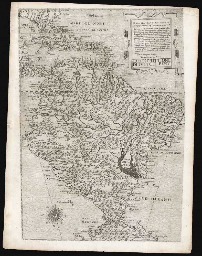
La descrittione di tutto il Peru.
1562 (undated) 20.5 x 14 in (52.07 x 35.56 cm) 1 : 2000000
1562 (undated) 20.5 x 14 in (52.07 x 35.56 cm) 1 : 2000000
Description
A superb, untrimmed, first-state example of Paolo Forlani's rare 1562 map of South America. It is the first large-scale, accurate printed map of the southern part of the Americas and is the only map of South America to be produced in the 'Lafreri School' of mapmaking. It is among Forlani's greatest works, and is a prize map not only for collectors of South America in particular, but also the Caribbean, Florida and Bermuda. Through its connection to the 1562 map of Diego Gutiérrez, it offers the most direct available link to contemporaneous Spanish mapping of her American colonies obtainable.
The map's waterways represent an advance on earlier attempts at the region: it is the earliest map of South America to give the Amazon River an east-west orientation (earlier maps have it flowing from roughly due south, extending beyond La Plata.) As for the Rio de la Plata, this map's portrayal of its massive, island-filled mouth is among the first to include and name the Uruguay River. The rivers of southern Brazil and the Uruguayan coast are also more completely represented. Forlani's engraving is superb: the dedication to Forlani's patron Contarini appears in an elegant strapwork cartouche, and an compass rose embellishes the southwest corner.
Not only this map's size and beauty, but its abundant detail of central and western South America sets it apart from earlier maps of the region. It reflects the knowledge gathered by Spain during its long efforts to subjugate the Inca of Peru, Bolivia, and Chile. Lake Titicaca appears, flowing into a Lake 'Tichicasa.' While this toponym is incorrect (it is derived from the same source as Titicaca), the portrayal of the one lake flowing into another, with no further outflow, is accurate: Titicaca flows into Lake Uru Uru and Lake Poopó in an endorheic system. Both lakes, along with the cities of Cusco, Quito, and Potosi, are placed far inland from their actual positions nearer the Pacific. The rich toponymy indicates that despite vagaries in placement, the names themselves derive from an informed source, certainly Spanish.
A Closer Look
Forlani depicts South America in a novel diamond form, and presents it as a uniformly mountainous place: pictorial mountains in profile fill the map. The scope includes the Caribbean, part of Central America, Florida, the West Indies, and Bermuda to the north. The southern limit embraces the Straits of Magellan, and the northern part of a massive Tierra del Fuego: Forlani's contemporaries typically extended the island to become part of a massive Terra Australis Incognita, and Forlani's own world reflects this assumption.The map's waterways represent an advance on earlier attempts at the region: it is the earliest map of South America to give the Amazon River an east-west orientation (earlier maps have it flowing from roughly due south, extending beyond La Plata.) As for the Rio de la Plata, this map's portrayal of its massive, island-filled mouth is among the first to include and name the Uruguay River. The rivers of southern Brazil and the Uruguayan coast are also more completely represented. Forlani's engraving is superb: the dedication to Forlani's patron Contarini appears in an elegant strapwork cartouche, and an compass rose embellishes the southwest corner.
Not only this map's size and beauty, but its abundant detail of central and western South America sets it apart from earlier maps of the region. It reflects the knowledge gathered by Spain during its long efforts to subjugate the Inca of Peru, Bolivia, and Chile. Lake Titicaca appears, flowing into a Lake 'Tichicasa.' While this toponym is incorrect (it is derived from the same source as Titicaca), the portrayal of the one lake flowing into another, with no further outflow, is accurate: Titicaca flows into Lake Uru Uru and Lake Poopó in an endorheic system. Both lakes, along with the cities of Cusco, Quito, and Potosi, are placed far inland from their actual positions nearer the Pacific. The rich toponymy indicates that despite vagaries in placement, the names themselves derive from an informed source, certainly Spanish.
Mountains of Silver
Among the details near Titicaca and its endorheic basin is Potosi, the source of more than half of the silver mined in the world in the second half of the 16th century. Founded in 1545, this is its earliest appearance on a specific map of South America. Potosi's early inclusion here represents an astonishing leak of information, as its silver mines and refineries had become an essential strategic resource for the Spanish Empire. Its placement so far inland from the Pacific may even have been deliberate misinformation on the part of a Spanish source - an effort to make the treasure city seem even less accessible.Forlani's Sources
Forlani's delineation of South America here is very distinct from the appearance of South America on his world maps, which copied Giacomo Gastaldi's 1546 world map. The present map conforms closely to the delineation of South America appearing instead on Gastaldi's 'lost' world map, conjecturally dated by Rodney Shirley to 1561. This is a puzzling date, because despite obvious differences in topology Gastaldi's toponymy shows a clear connection to Diego Gutiérrez's map of America engraved by Hieronymus Cock in 1562. This is an exciting link as Gutiérrez was cosmographer for the Casa de la Contratación in Seville, with access to the padron reál: the master-chart for all of Spain's colonial possessions. The details appearing on the present map therefore represent one of the only glimpses of official Spanish cartography of South America. The treatment on the present work of Lakes Titicaca and Tichicasa, and the arrangement of cities around and west of them, so closely resembles their appearance on the 1562 Gutiérrez that it is unreasonable to deny a connection. Gastaldi either based his map on Cock's engraving, or derived it from a more direct transmission of the cartography from Gutiérrez himself. This does complicate the record, for Cock's engraving for Gutiérrez was dated 1562, so if Gastaldi was working from a printed example, it pushes the conjectural dates of both his work and the Forlani later by a year or more. David Woodward, in his overview of Forlani's work, classifies Forlani's Peru map as belonging to his 1561 - 1563 oeuvre; so even if Forlani's source map is as late as 1562 it falls within the appropriate stylistic window.Maps of the 'Lafreri' School
Between 1544 and the 1580s, Rome and Venice saw the production of a genre of elegant, historically significant maps, now considered collectively as 'Lafreri-School.' The term is based on the survival of a 1572 catalog from the stock of publisher Antonio Lafreri. The close resemblance of this list to the contents of various bound collections of Roman and Venetian maps of the period led to these proto-atlases being attributed to Lafreri, despite the maps having been actually produced by over a dozen mapmakers, including Gastaldi, Lafreri himself, his heir Duchetti, the Bertellis, Camochio, Zenoni, Salamanca, Forlani, Ligorio, Tramezini, Zaltieri, and others. These cartographers, mapmakers, engravers, and publishers, some of whom shared formalized partnerships, left a legacy of some six or seven hundred maps, all of which are marked by scarcity due to small print runs and their not having been included in a standard atlas. Though these were generally sold in assembled-to-order, composite 'atlases,' the contents of these works varied wildly and those that survive are often poorly cataloged, and difficult to date.Publication History and Census
Woodward estimates that this map was engraved by Paolo Forlani in Venice around 1562, and dates subsequent printings based on his assessment of watermarks. The watermark of the present example is, unfortunately, indistinct. However, Woodward's description does not note the existence of two states of the map identified by Bifolco and Ronca, based on the condition of the plate's upper left corner. Early printings show an incipient crack at the mouth of the R. de Nieve west of Florida; in later printings, this crack has expanded to cause the loss of that entire corner following the engraved line of that river. The Bibliothèque National de France dates examples of that second state to c. 1566; the JCB dates their second state example to c. 1564. Our example does not exhibit the broken corner, and so we are following Woodward in assigning it an early date of 1562. Examples of the later state do appear on the market from time to time. We see neither auction records nor dealers' catalogs which accurately differentiate between the states of this map, but a review of the images of those available suggests strongly that this first state appears to be extremely rare on the market.CartographerS
Paolo Forlani (fl. 1560-1571) was an Italian cartographer and engraver of maps and views, working in Venice between 1560 and 1571. His early life is obscure: he is thought to have hailed from Verona. There is not even a date available for his death, although it is probable that he was claimed by the 1574-75 plague that killed 30% of Venice's population, and which seems to have impacted the printing community of that city disproportionately. Even within the narrow period of 1560 to 1571, there are about a hundred maps and prints that can be attributed to him, so it is probable that he was even more prolific. A good census of his work is complicated by the fact that most of his work was printed by other publishers under their imprints: Forlani engraved maps and views for Camocio, Bertelli and Zaltieri. Matters are complicated by the reprinting of plates by two or more publishers, as plates were handed down from one to another. More by this mapmaker...
Giacomo Gastaldi (c. 1500 - October, 1566) was an Italian astronomer, cartographer, and engineer active in the second half of the 16th century. Gastaldi (sometimes referred to as Jacopo or Iacobo) began his career as an engineer, serving the Venetian Republic in that capacity until the fourth decade of the sixteenth century. During this time he traveled extensively, building a large library relating to voyages and exploration. From about 1544 he turned his attention to mapmaking, working extensively with Gextantiovanni Battista Ramusio, Nicolo Bascarini, and Giovanbattista Pedrezano, as well as taking private commissions for, among others, Venice's Council of Ten. He is credited with the fresco maps of Asia and Africa still extant in the map room of the Doge's Palace. Gastaldi was also one of the first cartographers to embrace copper plate over woodblock engraving, marking an important development in the history of cartography. His 1548 edition of Ptolemy's Geographia was the first to be printed in a vernacular; it was the first to be printed in copperplate. As with his Swiss/German contemporary Münster, Gastaldi's work contained many maps depicting newly discovered regions for the first time, including the first map to focus on the East Coast of North America, and the first modern map of the Indian Peninsula. His works provided the source for the vast majority of the Venetian and Roman map publishers of the 1560s and 70s, and would continue to provide an outsize influence on the early maps of Ortelius, De Jode, and Mercator. Learn More...
Condition
Excellent. Few printers' creases, some marginal soiling, reinforced centerfold in margins away from printed image, else a fine, untrimmed example.
References
OCLC 494439704. Bifolco, S. / Ronca, F., Cartografia e Topografia Italiana del XVI Secolo, vol. 1 p. 358. Buisseret (2007) ‘Spanish Colonial Cartography, 1450-1700’, in The History of Cartography, vol. 3, pt. 1, pp. 1143-71. cf. Burden, P., The Mapping of North America, nos. 33 (mention in North America) 32 (Gutiérrez/ Cock). Further references: Shirley, R., The Mapping of the World, nos. 98 (Calapoda) 107 (Gastaldi 1561). Woodward, D.,Maps and Prints of Paolo Forlani no. 11. Woodward, D., ‘Paolo Forlani, Compiler, Engraver, Printer or Publisher’, in Imago Mundi 44, pp. 45-64. Woodward, D, ‘The Forlani Map of North America’, in Imago Mundi 46, pp. 29-40.